Author
and Trip Leader:
Bill Priedhorsky - Bio
Photo
Galleries: by
Momo Vuyisich, and
Ross Lemons
Second half of the week, second
wave - continued
from
page 1
The first eight
half-week participants arrived on Wednesday Nov. 11, and stayed
until Sunday the 15th. This wave included Walter Dunn,
Carolyn Bell, Momo Vuyisich, Jeff Click, Melanee and Dave Hand, and
Larry and Laura Cox.
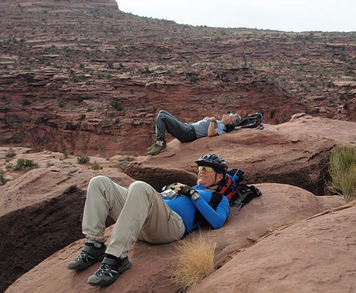
On Wednesday we
said goodbye to the first wave of half-week adventurers, and six of
us were left alone for the day. We decided to take a bike ride, and
rented Rosemary a bike at Poison Spider. Because we couldn’t shuttle
six bikes with our remaining two cars, we picked a route that
started in town, and rode out towards Hurrah Pass. We had lunch
about 4 miles short of the pass in the open valley of Kane Creek and
decided that we had found a perfectly adequate turnaround, since
none of us were excited about the final 600-foot climb to the pass.
We found a fine rest stop and the birthing petroglyph rock, both at
a summit a mile or two past the end of the blacktop.
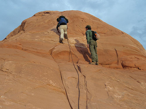
Strenuous exertion by
bikers Ross (foreground) and Jan, along the Hurrah Pass road.
On Thursday we
were back to full force. Momo was with us, and brought his extensive
experience with adventuring in the Moab area. His plan involved a
hike to Jeep Arch, reached via Gold Bar Canyon along the Potash
Road. Because our Tuesday experience told us that a party of 14 was
ungainly, we split. I took a party up the drainage east of Gold Bar
to the rim top, where we huddled inside a rockpile for lunch, hiding
from the wind. The climb out of the drainage involved an interesting
friction slope out of the upper drainage. Jan spotted a possible
route to the plateau, and I suggested that he follow it up. Although
he made it to the top via a chimney and ledge, we decided that the
route was unsuitable for the full party. Once out of the drainage,
we continued to the top by moving quickly up the bare slabs. Momo’s
party joined us at our lunchtime rock garden, and we split again for
the trip down. From the rim, we looked down directly into Arches. We
then hiked down to Jeep Arch and continued down into Gold Bar
canyon, successfully bypassing three or four pour-offs. Momo took
the other party along a counter-circulating route, high on the
northwest side of the drainage east of Gold Bar, to Jeep Arch and
the rim, then back to the cars via the bottom of the same canyon. We
reached the cars by about 3:30, and most of the group called it a
day. Bill, Jeff, Tom, and Dave decided to explore a potential route
at a high point of the road to Hurrah Pass, a couple miles from the
end of the blacktop. We had seen cars parked there the day before
and suspected that this was a way into the fin country. This day, we
indeed found a route that went up a chimney to find a terrific arch
on a plateau that looked like a dead end. But more careful
investigation showed a surprise – the gentlest fin was still plenty
scary, with exposure on both sides, but a 3/4” steel cable dangled
from the top, offering protection for the way up. Most of the party
took the cable to the top, which opened the path into the fin
country of Behind the Rocks.
Exploring the cable
route from above the Hurrah Pass road,
into the Behind The Rocks country south of Pritchett Canyon.
On Friday Jeff
and Walter took a shuttle to the top of Porcupine Rim, and rode
rented downhill mountain bikes – with 7” travel in the front shocks
– down to town. The guidebook said that this was not a ride to take
one’s girlfriend, and Carolyn, when she heard Walter’s stories of
exposure and 2-foot drops, agreed. Momo, Dave, and Melanee drove 90
minutes south to the Needles District, where they hiked to Druid
Arch and Chesler Park, then drove back to Moab in the snow. Bill,
Jan, Rosemary, Tom, and Mary took the cable route that had been
pioneered the day before and explored into the fin country. The
weather was blustery with a few drops of rain, cutting short our
breaks atop the fins. When the sun did come out, the lighting was
spectacular. Our high point was the mass of rocks just west of
Pritchett Natural Bridge. We tried to find a route down to the
Hunters Canyon Rim Trail by moving east from the Natural Bridge, but
there was none to be found. Instead, we hiked along the rim until we
found a route down to the road and trail, coming out at Spring
Canyon and hiking the road back to the cars.
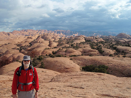
Fearless leader in the
Behind the Fins country, accessible via the cable route.
Our last day for
adventuring came too quickly. Larry and Laura went to Murphy Point
in the Island of the Sky district of Canyonlands National Park, and
Momo led five small hikes in the same district, including the point,
Granaries Pueblo, and False Kiva, taking Rosemary, Mary, Tom, Dave,
Melanee, and Ross. I led Carolyn, Walter, and Jeff down the Murphy
Trail to the White Rim, with wonderful views in the changing
weather, including snow pellets at lunchtime. The hogback is a
linear mesa a couple hundred feet above the White Rim, with views
all the way to the Maze country – another destination on my to-do
list. We hiked back up the Murphy Wash branch, then climbed the
1000+ feet to the Island. The path down the cliff face looks like an
impossible amphitheatre, but the well-developed trail actually
follows a talus slope on the south side of the slickrock. Nice
stairsteps make it a secure, if steep, trail. We then followed the
slickrock at the canyon rim to Murphy Point, where we had a last
look at the Canyonlands in the face of the gathering storm. Our
return drive was through snow and fog.
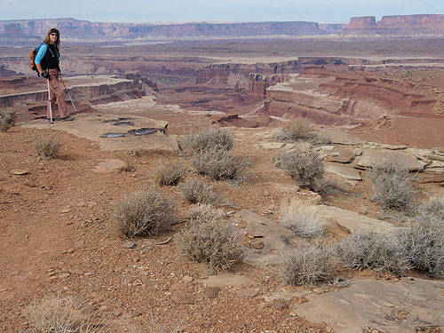
Carolyn on Murphy’s
Hogback, just above the White Rim.
Sunday was the
day to drive home, with everyone on the road by 8:30 AM. It was a
special week of strenuous adventures, fine dinners, and early
bedtimes. Even in 7 days of outings, we barely scratched the surface
of what Moab offers, and look forward to a return in 2010.
back to
page 1
