Author
and Trip Leader:
Bill Priedhorsky - Bio
Photo
Galleries: by
Momo Vuyisich, and
Ross Lemons
After an exciting long weekend in Moab in November 2008, we decided
that a full week exploring the canyons and slickrock around Moab
would be well spent. We based our trip at the
Moab Retreat
House, which was an economical way to house a large party. In
the short days of mid-November, we much preferred day outings from a
warm base to camping in the cold and dark.
We rented the
house for 8 nights. Six of us stayed for the whole trip, but most of
the participants changed out on Wednesday, the Veteran�s Day
holiday, when 8 folks left and 8 new folks arrived. The week-long
crew included Bill Priedhorsky (trip leader), Jan Studebaker,
Rosemary Irvin of Seattle, Ross Lemons, Mary Thompson, and Tom
Claus. We went out for dinner one night, to the Moab Brewery, but
otherwise divided dinner responsibilities with a 3- or 4- person
crew cooking each night.
The action came
in one or more outings each day, leaving the house between 8:00 and
8:30, and returning any time from mid-afternoon to 6:30 in the dark.
First half of
the week, first wave of participants
Besides the six
members of the week-long crew, 8 participants joined us for the
first half of the week, November 7-11. This first wave included
Kathleen Gruetzmacher and daughter Elena, Dennis Brandt, Marilyn
Yeamans, Dick Opsahl, Jackie Little, Dave Chamberlain, and Jeri
Sullivan.
Setting out on
Saturday the 7th, we broke up the drive to Moab (about 7
hours driving time from Los Alamos via Pagosa Springs and Durango)
with a scramble around Looking Glass Rock, which lies about 30
minutes south of Moab. There is no non-technical route to the
summit, so we contented ourselves with a scramble into the arch.
With an hour remaining before sunset, we drove to Hatch Rock, the
next landmark on the map, with a view towards another scramble. But
when we arrived, we found that the west valley of the rock was
filled with odd houses built half in and half out of the sandstone,
with solar panels on the ridges above. We guessed that the several
dozen buildings were a polygamist colony, this being Utah, and
viewed it from our distance. We confirmed our surmise when we
searched the Web that evening.
On Sunday, our
first full day for adventure, a small hiking group (leader Dick,
Marilyn, Rosemary, and myself) hiked the Devil�s Garden primitive
route in Arches National Park, with a close up view of long
Landscape Arch and terrific views of fin country � long, narrow
ridges of sandstone laid out in parallel rows � as you hike along
the highest tops. The primitive part of the trail is not exactly
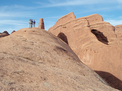
rugged, given that signs mark the trial. On the way back we took a
quick hike to Delicate Arch overlook, which takes one to a crest
about a half mile from the Arch, with views of the arch in the
context of its ridgetop location that are in some ways even better
than being right there. The rest of the gang loaded up their
bicycles and warmed up with an easy bike loop near Dead Horse Point,
led by Jeri, followed by a slickrock route in the same neighborhood.
Dick, Marilyn, and
Rosemary atop a fin in the Devil�s Garden.
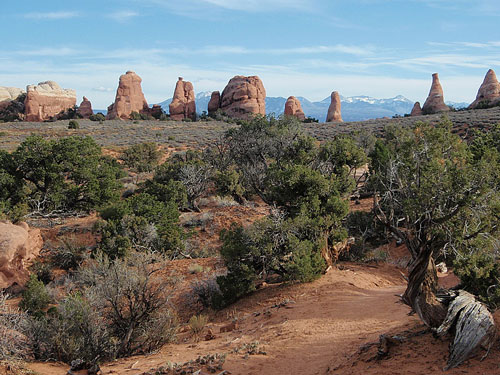
An avenue of fins
along the �primitive� trail in Devil�s Garden,
with the La Sal Mountains in the background.
On Monday, I led
Sunday hikers, plus Tom and Mary, into the Behind the Rocks fin
country, just over the ridge from Moab town. We parked at the mouth
of Pritchett Canyon, paid our $2 per head entrance fee, and hiked a
short distance up the canyon road until we saw tracks and a drainage
on the left (east) side of the road. We followed this drainage up
through a narrow chimney, and emerged onto an open shelf into a
wilderness of fins. We worked our way to the east, along the grain
of the fins. At one point we stopped for an exploration and break.
Tom proved that a seemingly unclimbable fin was a walk up; from the
top, we had views across the river into Poison Spider Mesa and
farther east into the fin country. At lunchtime, beyond a small
vegetated mesa and atop another fin, we considered options. Although
it looked difficult, we decided to follow a faint trail to the
north, with hopes of connection to the Moab Rim jeep trail. After a
few turns, we indeed broke through into more open country that we
crossed to reach the jeep trail. We followed it down, missing a turn
and backtracking about a half mile, then hiked down the incredibly
steep and tire-streaked jeep route to the blacktop. We tried to
climb a mass of slickrock on the rim above Moab town, but were
stopped by a line of low cliffs. The loop to the blacktop totaled
8.5 miles and deposited us 1.9 miles from the cars, which Tom
hitchhiked and Bill jogged. The rest of the party organized a bike
ride on the White Rim trail that they found fabulous, driving in
almost two hours along the Potash Road. The drive out along the
semi-technical Schafer Road, to Island in the Sky.
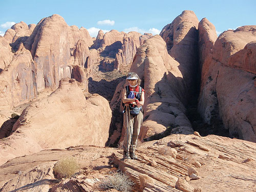
Marilyn in Behind the
Rocks, a wild maze just over the ridge from Moab town.
Tuesday was the
only time that all fourteen hiked together. We obtained a permit for
Fiery Furnace, and hiked that sandstone maze in the backwards,
clockwise direction. The Furnace was as beautiful as ever, but the
adventure was not quite the same as last year. We remembered the
route too well, and found our way through without a false turn. The
traverse took only about two hours, with lunch atop the last rocks
on the way out. The group split for an afternoon adventure. Several
took the classic route to Delicate Arch, and I led the rest into the
wild fin country just north of Fiery Furnace. We found a route to
the top that involved fin walking, a tight squeeze, and a mantle
that Tom led. At the very top we broke out of the fins, and saw an
easy way down just to the south. The same set of trails give access
to the top of the fins of the Fiery Furnace. We tried to find a way
directly down to the road by moving to the north. This gave us a
wonderful adventure in another maze, but eventually time ran out and
we gave up. From the top, it was just 30 minutes back to the cars.
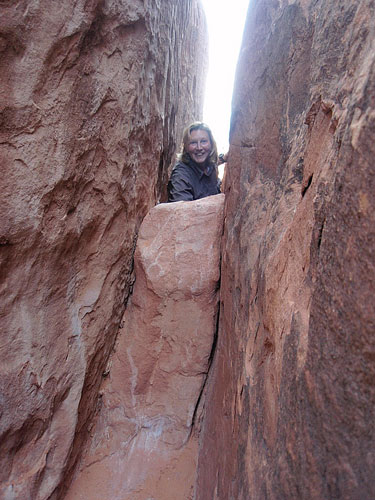
Kathleen ascending a
squeeze on the way to the mesa top north of the Fiery Furnace.
continued on
page 2
