Author
and Trip Leader:
Bill Priedhorsky - Bio.
Photo
Gallery: by Jan Studebaker - click
here.
Participants:
Karl and Virginia Buckendahl, Kathleen Gruetzmacher, Jackie Little,
Ron Morgan, Terry Morgan (no relation), Martin Staley, Jan
Studebaker, Marilyn Yeamans, and Bill Priedhorsky.
Continued
from page 1: On Tuesday we
headed for the local high points – two isolated mesas that stood
about a thousand feet above the canyon bottoms. We started up the
canyon immediately opposite camp, but were stopped in its damp upper
reaches by poison ivy. By working our way under the cliff line on
the south edge of the canyon, we found a path onto the slick rock,
and reached the first mesa at the end of the longest slickrock climb
in my memory. The mesa was a rounded white dome topped by a red
numb, an isolated fragment of an overlying red layer. The top felt
like the center of the Universe, isolated above a sea of slickrock
wilderness in every direction. The USGS marker nearly at the summit
stood about 30 feet below the summit of a multi-acre red mesa about
a quarter-mile (?) away. To cross from one peak to the next, we
found a path across a deep intervening gully, up the broken rim of
the red rock, and some distance across the red soil to a gentle
peak. From the top and edges we could look down into the upper
reaches of the South Fork of Ticaboo, and saw the water tank that
marks the trail into that tributary.
Our biggest adventure of the trip came
on our return from the summit. With a view towards a straightforward
route back to camp, we dropped down the gully crossed on the way to
the mesa summit. This required some rope work down the fragile rope
of a steep gully, and took us into a deep canyon that promises a
clean shot to the rim just above camp. Things did not work out that
simply, however. Our canyon ended up ten feet above a cross canyon,
whose far side was our path to home. Karl went uphill and found a
friction path up and over the domes, but one too steep to take the
whole party. Instead, we lowered most of our team by rope to the
cross-canyon bottom, while Martin and Ron were brave enough to drop
that last 7 feet unroped. A deep wade took us to an easy step out of
the cross canyon, and onto the rim rock and way home. It was nearly
7 PM by the time we reached camp, but things worked out much better
than I thought when I first encountered the obstacle, scouting solo
ahead of our main party.

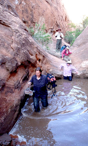
The last obstacle
on our way home – a chest deep pool
below the drop into the cross canyon.
Wednesday was the middle day of our
trip, and we relaxed our ambition after two hard days of hiking. We
crossed just south of the mouth of the Middle Fork. We found
some nice semi-narrows, with pools suitable for a quick dip, and
reached a mesa top for another view of the slickrock sea. A
highlight of the Ticaboo country is the Henry Mountains, which loom
in the background so often, as one looks up a canyon or across a
sandstone monument. The contrast between the dark rock of the Henrys
and the sandstone is always a surprise. Our Wednesday mesa was
covered with boulders, and an isolated piece of the pre-erosional
surface that reached to the pass between the two peaks of the Little
Rockies.
On Thursday, we went up the ridge
between the North Fork and East Fork, looking up the North Fork to
the flat slickrock expanse that was the end point of our February
2009 exploration. (At that time, Kathleen, Momo Vuyisich, and I
established that we could reach Ticaboo oasis from between the
Little Rockies, but at considerable distance. From our viewpoint, we
crossed the East Fork, another sandstone drainage, then up a set of
waterpockets to a view up one of the deep canyons in the fingers of
the East Fork. Jan, Marilyn, Ron, and I explored up the easternmost
of the fingers and the rest up one of the western ones. Both fingers
were deep sandstone canyons, but if there were any slots at the
upper end, they were blocked by thickets and poison ivy.

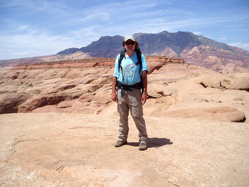
Your fearless
leader and author, with the Henry Mountains behind.
Our last hike, on Friday the 8th, was
the most spectacular of all, though our distance was modest. Our
destination was the drainage south of the Middle Fork, which drains
the northwest side of Tuesday’s red mesa. We explored a region of
wildly vertical topograph, cut by multiple drainages and structural
cracks. The heart of this country was almost frightening in its
complexity. There was not only a complex network of drainages, but
cross-cutting structural features almost as deep. The day started up
a side drainage, urged on by Martin, which led to a pretty slickrock
pool and then to a steep bare drainage that steepened and narrowed
until it was impassable. Once out of Martin’s drainage, we continued
up canyon to a confluence of multiple drainages, and sat high on the
slope above for lunch, looking across the slickrock domes to the
Henry Mountains beyond. Our further adventures took us around
various corners of a very mazy section. We tried to reach the gentle
high red mesa of Tuesday, trying up a side canyon and a deep
structural rift, but were blocked by distance in one case and a
steep waterfall in the other.
On the last day, we left camp at about
9 AM and reached the deep pool at the bottom of Peshliki by about
11. We swam one more time, watched and fed the little fishies in the
next pond down, then caught the boat at the water’s edge for run
back to the docks. In our whole week upcanyon, we had seen exactly
one party of two backpackers come past us. But in our hour’s trip
along the lake, we passed about a dozen boats, and knew that our
escape from civilization was over.

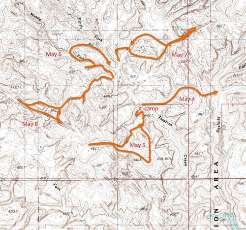
We found an
adventuresome day hike each of our five days in camp.
click map for larger view
back to page 1