Author
and Trip Leader:
Bill Priedhorsky - Bio.
Photo
Galleries: by Momo Vuyisich - click
here, and Tom Claus - click
here
Participants: Momo
Vuyisich, Melanee Shurter Hand, David Hand, Mary Thompson, Tom
Claus, Bill Priedhorsky, Mike Steinzig, Dara McKinney, Karl
Buckendahl, Ginger Buckendahl, Larry Cox, Laura Cox, Paula Barclay,
Brian Lally, Kathleen Gruetzmacher, Ross Lemons, Roy Michelotti, and
Chris Michelotti.
As is our custom, the Los Alamos
Mountaineers spent the President’s Day weekend of February, 2009,
exploring the archeology and slickrock around Bluff, Utah. This trip
has been an annual event since 2003. In past years we have had as
many as 45 participants. This year we went with a comfortable party
of 18, which nicely divided into two for day hikes, and fit nicely
into the Far Out Bunkhouse for potluck dinners. The trip included an
exploratory hike in the Ticaboo area on Friday the 13th, day hikes
around Bluff on the 14th and 15th, and a scramble up a crack to the
mesa top above Bluff on the morning of the 16th. Our hikes were day
hikes, spending the evenings warm and comfortable in town; 12 of us
stayed in the Recapture Lodge, and 6 in the Far Out Bunkhouse.
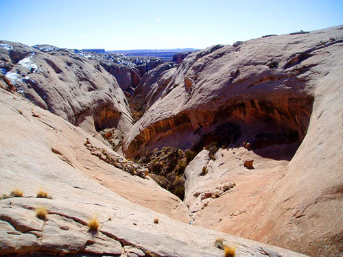
The objective of the Ticaboo
exploratory hike was to find a route between the two peaks of the
Little Rockies (Mount Holmes and Mount Ellsworth), at the southern
end of the Henry Mountains, and make our way into the drainage of
Ticaboo Canyon. Our hope was to find a route by which llamas could
take us to the oasis in upper Ticaboo Canyon, about three miles
upstream from Lake Powell, to make a base camp for our May trip. We
found a cross-country route through the pass, then edged along the
flats below Mt. Ellsworth to a viewpoint and lunch spot just above
the north fork of Ticaboo. The route involved ups and down, some
steep, over the drainages coming down from the peak, but appeared to
be reasonably trafficable for llamas. Momo, Kathleen, and I hiked
about 6 miles each way, reaching a slickrock flat that was about 3
miles upstream from our intended camp. We found no signs of human
passage despite the obvious route through the pass, which formed a
natural funnel for any traffic from the west into the Ticaboo and
Four Mile Creek drainages. The country was wonderfully remote and
empty. We felt that we were the only people for miles.
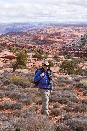
Trip leader Bill
Priedhorsky in the foreground, with the convoluted slickrock
of the upper Ticaboo country behind. Photo courtesy Momo Vuyisich.
On the return, we cut about 1/4 mile
north into Four Mile Creek, and hiked upstream to the pass, past
chockstones that would block llama passage. We found permanent water
in Four Mile Creek about 1 –1 1/2 miles east of the pass, including
a campsite with some signs of past visitation. Despite the
llama-suitable route, schedule complications precluded a llama trip
this spring, so we will backpack into the oasis from Lake Powell, a
3-mile trip. Our return drive from the trailhead to Bluff took just
2 hours and 20 minutes, driving briskly.
The Bluff trip proper began at 8:30 AM
on Saturday the 14th, when the 18 of us converged on the Bunkhouse
to divide into day trips. Momo led a party of 12 up the Butler Wash
road to two archeological features on Comb Ridge, the Processional
Panel and Monarch Cave. These are well-known destinations that are
called out in the guidebooks, but still very worth while, with
stunning ruins and petroglyphs. The trip to Processional Panel took
two tries, because it was easy to misinterpret the description in
the guide, taking the party well out of the way and requiring a
return almost to wash bottom to try again. But every part of Comb
Ridge is an adventure, so the detour was hardly wasted.
A smaller party, including Karl,
Ginger, Paula, and Brian, Kathleen, and myself, explored up a small
canyon system just west of Cottonwood Wash. We started up the sand
dune visible from the highway to take a look at the petroglyph
panel. We found a couple of small panels of interesting petroglyphs,
but found that evening that we had missed the main show. Our
objective was a cowboy trail leading to the mesa top. We explored a
long side canyon to the right, well past the point where it became
clear that cowboys could not go, at least not with their horses. The
canyon narrowed and became extremely brushy, so that we had to crawl
under branches. Only two of us went through a wading pool that left
us with wet boots for the rest of the day. From the point we could
see a ancient Indian (Moki) way out, but a deep pool blocked our
way, and we were not ready to wade up to our waist in mid-February.
We backed out of the canyon, finding an ancient escape route up a
crack and a defensible hiding place near the mouth. From the ledge
at the top of the hiding place, we could see a trail on the west
side of the canyon that seemed to indicate a way out. Once we
started up that trail, we could see the cowboy trail switchbacking
up the opposite (east) side. But we continued on our way, and found
a Moki route with two sets of steps that took us to the mesa top. We
explored a large expanse of slickrock up top, reaching a viewpoint
overlooking the west end of Bluff, and returned to the cars via the
cowboy route.
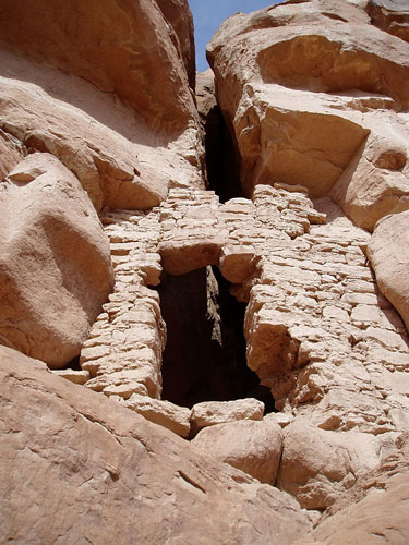
Moki stairs led to
an slickrock expanse. We were impressed that such massive wildness
could be found just three miles from Bluff town, and a mile from the
Federal highway.
On our second hiking day, seven of us
joined a professional tour of petroglyph art at a site below Cedar
Mesa, led by Vaughn Hadenfeldt
of Far Out Expeditions. He was knowledgeable and enthusiastic about
the rock art, and the participants saw much more than we usually
discover on our own. For details and rates for Vaughn’s tours, see
his web site,
www.faroutexpeditions.com.
Elsewhere that same day, two couples
went off on their own, one returned home early, and the remaining
five hikers set up a hike to explore Saturday’s canyon complex and
the lower part of Cottonwood Wash. Kathleen and I hiked one way, and
Momo, Tom, and Mary the other, meeting just above the Moki steps out
of a side canyon to Cottonwood Wash to trade car keys. Our personal
radios were key to making the rendezvous possible. In the Cottonwood
drainage, we found a beautiful two-room ruin and a spectacular
granary cemented into a promontory point, but missed a great deal
also, as Vaughn pointed out later. Once on the top, Kathleen and I
found a rock art panel above the Cottonwood tributary, and descended
the first day’s Moki steps, but not before hiking too far to the
west before the backtracking to the correct drainage. On the way
back to the car, we found the main sand dune petroglyph panels, just
where they were supposed to be.
Granary cemented
into a promontory point in a tributary of Cottonwood Wash.
For our last morning’s adventure, we
followed Vaughn’s hint that an apparently vertical crack in the
cliffs above Bluff gave passage to the mesa top. Eight of us were
left for the last morning, and Tom, Mary, Kathleen, Momo, Dave, and
I went up the crack, while Ross and Melanee satisfied themselves
with a quick exploration, then hiked up Calf Canyon instead. The
route was not trivial, requiring some rope help by the more
experienced climbers to get the rest of us to the top. We chimneyed
up a 15-foot vertical crack, then sidled sideways through a section
narrower than a shoulder width. At the end of the narrow section, we
found a 12-foot pile of chockstones blocking the way. The slot was
too narrow to change our order of ascent, so Kathleen, at the head
of our file, had to lead the move. She led us up the chockrocks with
some help from Momo, who was next in line. Once up, the crack turned
and shallowed for a straightforward path to the top. A traverse at
the edge of the mesa top was a bit exposed, so Tom set up a handline
to protect it. The mesa top was directly above “downtown” Bluff, and
we enjoyed the view before returning the way we came. A late lunch
at the Three Rivers Brew Pub in Farmington was the last official
activity of the trip, and we reached home in Los Alamos
expeditiously, spending a little under six hours on the road.
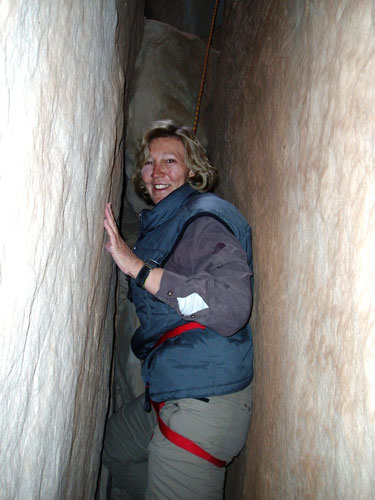
Kathleen in the
skinny part of an apparently vertical crack in the cliffs
above Bluff town, which leads to the mesa top.
