Los Alamos Mountaineers
Outdoor adventure for everyone!
You are here
Sand Canyon, Escalante May 26-June 3
Date:
Sat, 2012-05-26
Leader:
Bill Priedhorsky
Difficulty:
Moderate
Technicality:
Moderate
This was a non-Mountaineers trip involving a lot of Mountaineers members. Details in the trip report that will follow.
- Log in to post comments
Theme by Danetsoft and Danang Probo Sayekti inspired by Maksimer
Comments
Sand Canyon trip report
Sand Canyon, May 26 - June 3, 2012
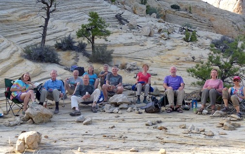

Our spring 2012 trip to Sand Creek was my 97th adventure the canyon country, continuing a series that started in 1979. In the past few years we have forgone backpack trips in favor of packer-assisted outings. It is less work and just as much fun. For this outing, BJ Orozco of Boulder, Utah, who operates as llama2boot, packed the gear that made possible a camp with cooking tables and a two-burner stove, wine cellar, and a social circle of folding chairs. It was not luxurious by some standards, but a big notch up from backpacking. From this base we explored the slickrock wilds of the Grand Staircase/Escalante National Monument, and the Death Hollow Wilderness, in a series of day hikes. Participants included trip leader Bill, and Dave, Marilyn, Patti, Kathleen, Karen, Mary, Jan, Don, Terry, and Dennis. For Don and Patti, this was their first trip to the canyon country. All of us were ready for adventure. As the bumper sticker says, “my favorite vacation is your worst nightmare”.
All of eleven of us at dinner, in our camp chairs taking advantage of the shade of the rock formation above camp. The trip’s success came from the cooperation, hard work, and sense of adventure of the entire party. After dinner each night, Bill the storyteller (purple) entertained the group by reading from Pamela Christie’s mystery “The King’s Lizard”.
We left Los Alamos on Saturday, May 26th and the following day. Most overnighted in Bluff, Utah, about 5 ½ hours along the way. The party that left on Saturday had time enough to stop and hike midway, in Capitol Reef or along the Burr Trail, while the Sunday crowd drove straight through, leaving at about 7:15 AM and arriving at about 5:30 PM. Everyone met by chance in Torrey, Utah, driving together for the last leg through the aspens over Boulder Mountain. This route from Los Alamos, via Hanksville, was 519 miles.
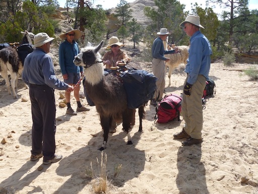
Most of the party overnighted at the Boulder Mountain Guest Ranch, the location of our trailhead. Dinner at their Sweetwater restaurant was fabulous, served family style (homemade pasta, ribeye steak, and pulled pork, as was the breakfast. We met BJ and his wife Abbe (sounds like “Abby”) in front of the lodge at 9 AM to pack, which was one of the smoothest such operations ever. Because of the size of our party (11) compared to the llama string (6), BJ needed to mount two round trips, both of which went out fully loaded. Despite the double load, all of our gear was in camp by about 3:30 PM. The route to camp was 2.88 miles, and took us no more than 1.5 hours. This was the coolest day of the trip, with temperatures in the low 70’s, and frost beneath the sprinklers at the ranch. By the end of the trip, highs reached the less comfortable mid-80’s.
We shared responsibility for the community gear – stove, fuel, water filters, ropes, etc. – details of which can be found on the trip web page. We were surprised how little fuel we used for the stove, only 3.5 1-pound cylinders. The weather was warm, dinners were simple, with one cooked on charcoal, and we were out for only 5 nights, rather than our usual 6. In the future, we’ll plan no more than 8 fuel bottles for a 6-night, 11-person trip, even including contingency. Another key item was the wine cellar. A 3-liter box was all we needed each evening, so we carried out excess wine, also.
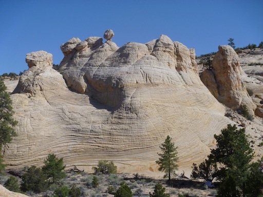
Camp was a flat under an impressive rock formation, with Sand Creek about 100 yards away. A flat rock surface made for nice kitchen and story circle, but only once the sun was down. Our tents were scattered over a couple hundred yards of the canyon, with a pit toilet dug at the far end. Although Sand Creek was close, it was a little tricky to access because of its high banks. We built a rude stairway for hauling water back to the filters at camp.
Rock formation immediately above camp, Bill’s tent at the lower right. The balanced rock stayed put for the duration of our stay! Campers who are worried about getting old are advised to camp under it.
Jan and Mary were not content to stay in camp the first day, but immediately set out on an explore up the slickrock to the left of the balanced rock, overland east of Sand Creek, down the slickrock reaching Sand Creek somewhat upstream of the Sweetwater confluence, then upstream back to camp.
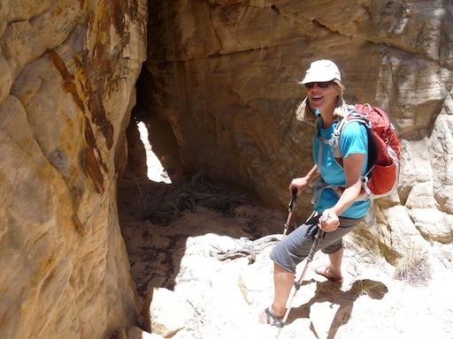
On Tuesday, our first full day, we crossed the creek, rounded the top of the canyon just south of camp, then climbed a low but steep-walled mesa between Sand Creek and Death Hollow. We eventually came to the edge of Death Hollow and worked our way down to the slick rock above it. The party split after lunch into more and less intrepid contingents, with Mary, Jan, Bill and Karen finding a way down through a cliff layer that involved a one-way jump into a sand pit followed by exit through a tunnel at its lower end. We were pretty sure that we could go out the bottom once we jumped in, but confirmation was not possible until we made the jump. The rope was with the other party, so climbing back out would be tricky. We figured that they would probably come rescue us after a day or two, anyway.
Mary about to exit the sand pit, which (fortunately) had a underground exit that took us to the bottom of the cliff band. She may not have been smiling if the pit had been a dead end.
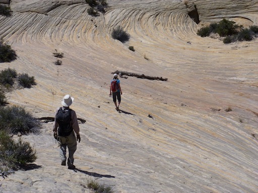
Continuing down the slickrock, we were able to follow a rock fin almost to the river, but the slope was slightly too steep for comfort. There was a piece of rappel hardware that could have supported an easy rope assist, but once again, our rope carrier, Dennis, was not at the pointy edge of the exploration, but rather sitting under a tree with most of the women in the party. We climbed back, ascending the full depth of Death Hollow less 20 feet, then started back cross country, following one drainage then crossing north to another. Most of the party slogged back to camp over the mesa tops, but a party of 5 dropped into the canyon down an improbable slope, reaching a rock formation we called the navel, then down the canyon (logically named Umbilical Canyon) to Sand Creek, following it upstream home. Bill, Marilyn, and Dave stopped to swim. The total mileage for the day was 9 miles for the Umbilical Canyon crowd, a little less for the short cutters.
Mary and Dave approach swirl of rock at the bottom of Umbilical Canyon that is clearly the navel of the Universe.
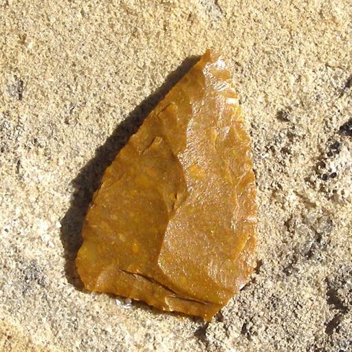
We were struck by the huge number of lithics everywhere in the vicinity. Hiking across the flats we would find them strewn like pebbles, both broken blades and remnants from tool manufacturing. The raw material seemed to be a chert that lie just below the basalt layer.
One of the thousands of prehistoric rock artifacts that we found on our travels. Photo courtesy Dennis Brandt.
On Wednesday, we hiked a total of 8 miles down Sand Creek, up Umbilical Canyon and out the same way we had entered it the day before, then crossed into the next canyon to the south and followed it downstream, through a huge slickrock bowl, to Sand Creek.
Lunch and a foot soak along Sand Creek, at a point farthest downstream of the trip.
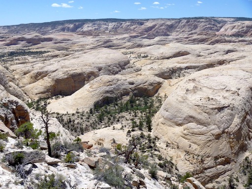
After lunch we recrossed Sand Creek to the west, climbing a ridge that gave huge views to the south, past several campsites of our past expeditions, to the orange rocks of the Egypt cliffs far to the south. What was striking was the transition, in not much more of a mile, from the pinyon/ juniper mesatops to slickrock that continued for miles to the south. We crossed the Boulder Mail trail from south to north on the way back. Bill and Dave split off from the rest of the party, taking the Mail Trail to Sand Creek, then trails along the creek back home, with a swimming break at a spot where a flat sandstone table was cut by the creek. They waded the last stretch to camp, which (1) cooled them down and (2) kept them out of the thickets. The corral fever crowd again slogged back across the dry and dusty mesa top. Back in camp, we relaxed before dinner, all except the two who were on dinner duty that night.
The next day, Thursday, we hiked up Sand Creek to the first drainage north of camp, following it to the divide with Death Hollow, then climbed a 7000-foot mesa that paralleled it. The views into Death Hollow were stunning as we followed the mesa edge to the north. The weather had warmed enough that some of the party were starting to have real difficulties (headaches, annoying disposition) with the sun and heat. About half the party turned back, and the rest went downhill to a plateau above the upper, dry part of Death Hollow, then worked their way back to the north of the mesa, picked up the beginning of a drainage that became the second Sand Creek drainage above camp, following it past a dry fall and through sandstone obstacles near the confluence, reaching Sand Canyon, and another swim, about a mile above camp, for a total of 7.5 miles on the trail.
The lower reaches of the first drainage upstream from camp had their interesting stretches (Dennis above a dry fall).
Views of upper Death Hollow from the mesas above were stunning, with miles of sandstone in every direction.
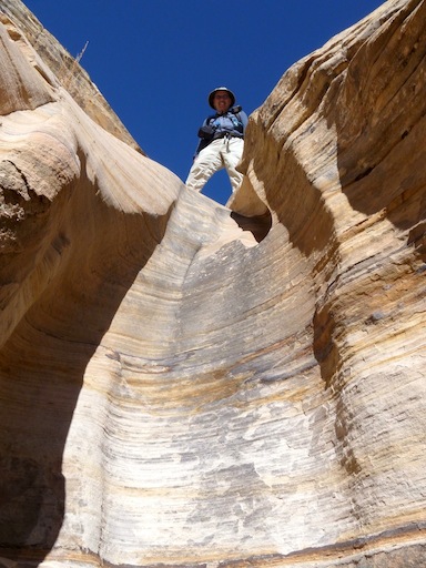
Friday was our last full day, and our hiking plans only formed once we hit the trail. We climbed the rocks above camp to the east, picking up a trail that took us much farther to the north than we anticipated. We reversed course, backtracking to the southeast along the ridge that separates Sweetwater and Sand Creeks, looking at the drainages on the east side of Sweetwater, our new goal, as we went. Thickets and thorns made it hard to move down Sweetwater, but eventually we reached the confluence with Big Hollow, the first of the eastside drainages. The lower section was dry, sandy, and hot, but it quickly closed into a cool yellow narrows. The narrows reached a dead end with a cliff and chockstone, so we climbed out of the narrows and had lunch in the shade just above that chockstone. The party split at the mouth of the next drainage downstream, with a few of us continuing to the canyon rim east of Sweetwater, atop a rock spire, then into a dry drainage (the path of the Boulder Mail Trail) and down to Sand Creek. By the time we followed the creek back to camp, stopping to swim along the way, our GPS showed 7.2 miles for the day.
The narrows of Big Hollow ended in an impassable falls capped by a huge chockstone.
When we set out on a Utah trip with a full week ahead of us, our time to adventure seems unlimited. Our trip had been on our minds for weeks as we planned and prepared. But all too soon our few days were over, and right on time, at 10 AM on Saturday morning, BJ and Abbe came into sight, 6 llamas in tow. We had the good luck of cloud cover for our 1.5 hour hike out. Back in civilization, we cleaned up, shopped, and had dinner at the Burr Trail Grill, resting before the big drive back to Los Alamos. On Sunday we left Boulder a little before 8 AM, comfortably caught the 10 AM ferry (figure a 1h 45 m drive from Boulder), lunched in Farmington at the Three Rivers Brew Pub, and reached Los Alamos around 7 PM, driving about 468 miles, less than the way in thanks the ferry shortcut.
Llama loading was just as smooth on the way out as the way in. Of course, we didn’t have to do a second round trip in the sun, like BJ and Abbe.
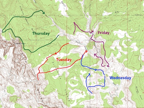
In summary, the lead party took the following paths over our 4 days of adventuring:
Click on this map for a higher resolution version