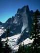
Mount Slesse, NE Buttress
By: Bruce Bindner | Climbers: Larry Sverdrup, Andrea Koenig |Trip Dates: August 20-21, 2005
Photo: George Bell, Jr.
® The author(s) and naclassics.com | ![]() Back to climb page
Back to climb page ![]() NAC Home page
NAC Home page
|
|
Mount Slesse, NE Buttress By: Bruce Bindner | Climbers: Larry Sverdrup, Andrea Koenig |Trip Dates: August 20-21, 2005 |
|
Photo: George Bell, Jr. |
® The author(s) and naclassics.com | |
|
I had once before tried to climb Slesse in July after a winter that had a ton of snow. Driving in on a nearby road, I glimpsed a tall mountain far above plastered with vertical fluted snow chutes. I was aiming to do a rock climb, but realized that the conditions were poor for that, so we bailed to Squamish where there was indeed dry rock. This time I was already in Seattle for the week on business. The rental car guy offered me a free upgrade for a 4WD SUV, probably because the high price of gas was swelling the inventory of such vehicles. Knowing that I would have to drive a rough backcountry road, I gladly accepted. When Andrea flew into Seattle she rented a second car to leave on the far side of the mountain for the return after the descent. We convoyed to the Canadian border, and proceeded to Chilliwack, roughly 2.5 hours from Seattle. Exit 119 off of Trans-Canada Highway 1 takes one to Vedder Road. Heading south on Vedder road we eventually turned left onto Chilliwack Lake road (just before the bridge over the Chilliwack River) and headed east. This road parallels the river all the way to Chilliwack Lake. We drove the approximately 13 miles along the river to reach Slesse Creek Road, where we encountered a bridge over a clearly marked Slesse Creek with an adjacent road. I took that road assuming that it was Slesse Creek Road, but this was an error. The correct road is the next right after the bridge, a fraction of a mile further down the road. Continuing to a fork in the road, we discussed which fork was correct (neither of course). We chose the drivable fork and soon pulled over to bivy for the night. The next morning we wasted time exploring further up the road. We found similar features described in the Nelson guide, but there was nothing to convince us we were in the right place. We left our second car where we spent the night, not realizing that it was nowhere near where it was supposed to be. Driving further down Chilliwack River road to the campground, we found the correct road to the trailhead. We encountered one tricky berm, but any decent 4WD can make it. At the trailhead parking lot (just a turnout a short distance before a gate in the road) there was an obvious trail following an old road, but a posted sign pointed the other way further up the road as the way to Slesse Trail. We quickly packed up, but decided that two sleeping bags and two bivy sacks was just a little too much bulk and weight to be taking on the climb, so instead we took one of each. In an emergency if it rained we could both cram under the bivy sack. If it was warm, one of us would get the bag, and the other the bivy sack. Our hope was to haul our gear whenever possible, and we had brought just a single pack designed for hauling. For the hike in Andrea carried the pack containing 3 gallons of water among other things, while I carried the two ropes and rack. We followed the road past the gate and soon encountered a large cairn on the side of the road marking a fairly decent trail. A few hours of hiking brought us to the memorial to Canadian flight 810 which crashed into the top of the mountain in 1956 killing all on board. No recovery of the plane or the bodies was ever undertaken, and it is now illegal to remove anything pertaining to the crash from the mountainside. The memorial overlooks a huge rock strewn valley, with the northeast buttress of Slesse at the far left end. A guy from Chicago who was, hiking around to scope the approach for a one-day ascent of Mount Slesse ran into us. He told us about the trail up to "Propeller Cairn." We now had a choice: drop down and cross the valley to the base of the climb, or hike to Propeller Cairn and traverse from there over to the so-called bypass route. I had fully intended to do the complete buttress, which is rarely done these days, but Andrea talked me into the much more popular bypass route. There are numerous guidebooks describing this climb. One is "Selected Climbs in the Cascades" by Nelson and Potterfield. We carried a laminated copy of their topo with us on the climb. Another is "Cascade Alpine Guide" by Fred Becky, which although older is packed with information and pictures. It does not, however, describe the current fashion of leaving a second vehicle on the southwest side of the mountain. The Northeast Buttress is flanked on the right by the east glacier (as you look up), and on the left by the so-called pocket glacier. Both are capable of dropping debris, so the approach to the bottom of the buttress entails some danger. A climber was killed in August of 1980 by debris from the pocket glacier. However, in recent years, the pocket glacier has been completely avalanching and melting away by July. The bypass route attempts to avoid the debris hazard by ascending the pocket glacier to the top and then traversing onto the buttress. That is, of course, only safe if the glacier doesn't avalanche when you are walking on it. If it is gone, the slabs underneath make for an easy hike. Supposedly the pitches on the lower buttress avoided by the bypass are of a distinctly different and less pleasant character. The crux is higher up in any event. Fred Becky has given the bypass route his blessing according to the trip report by George Bell. To reach the bypass we continued on the original trail, which at first was heavily overgrown, but soon enough opened back up a bit. I couldn't help but think that the trail had been so well maintained primarily because of the memorial. Once past the memorial, you are on your own. We gained considerable altitude and eventually reached Propeller Cairn, where one of the propellers of the plane is mounted in a huge cairn. There are some nearby bivy sites. There was flowing water nearby, so we wouldn't have needed to pack in all of that water. A large ridge rose in front of us across an expanse of slabs, but this is not the Northeast Buttress, just an intermediate ridge. We hiked across the slabs and climbed over the intermediate ridge at a prominent notch, and worked our way down to the slabs of the pocket glacier, which was gone as advertised. It was now too late to continue, so we set up camp. It appeared that the base of the buttress was very close and could be easily reached from our location. This puzzled me as we had gained considerable altitude. Evidently crossing the valley to reach the buttress would also entail altitude gain. At any rate, there appeared to be low danger of being hit by debris from the East Glacier on the approach to the base of the buttress because most debris would not make it that far down. Andrea took the sleeping bag and I took the bivy sack. It was a little on the cold side that night. However, places where there are glaciers tend to be cold, so I should have anticipated that. The next morning Andrea filled an empty bottle in a stagnant pool of water and added a handful of iodine tablets, to bolster our water supply. A thunderous crash on the East Glacier brought my attention to a rock the size of a car rotating in apparent slow motion in mid air. Still the debris from that event did not threaten the approach to the toe of the buttress as the East Glacier had receded so far back. Two guys came past us on their way to the bypass route. Soon we were following them up the slabs, which were easy hiking in dry conditions. I wondered how slippery they became when wet. Although the glacier had avalanched away, there were still a few huge patches of snow/ice here and there, which if they were to slide would be perilous. I felt compelled to hurry when I was underneath them. The bypass route begins on a wide ramp. Andrea charged off as if she was going to solo up to the crest of the buttress. I convinced her to rope up before things got interesting. We obviously were not going to haul the pack for some time, so Andrea volunteered to become the pack mule, and I led off. The traverse became exposed and footholds were sometimes in damp soil or grass, but the initial pitches were more like class 4. On the buttress we found ourselves working up amongst trees and bushes till finally we hit a steeper rock wall. Andrea led a 5.8 pitch. She put the haul line in a wall hauler but she didn't bring a jug with which to body haul. As I followed I boosted the pack as needed. This would turn out to be the only pitch we hauled on the entire route. The idea of hauling was a boondoggle, and the hauler and jugs were dead weight. Possibly had we done the very bottom of the buttress, we might have hauled a few more pitches. We climbed and sometimes simul-climbed our way up the mountain. Occasionally we found ourselves traversing or climbing on short grassy sections. We took the north side traverse option after pitch 10 (Nelson topo) traversing on 5.7 slabs at one point. The buttress crest is regained below a short clean 5.8 crack pitch. Andrea led the 5.8 layback to reach the bivy sites, and I had the joy of following it with a large pack on my back. At the bivy sites we joined another party ahead of us - two Canadian fellows, one a transplanted Australian name Paul, but he pronounced it "pole". They might have been further ahead, but apparently got off route below and burned a bunch of time. In addition, two guys from Portland Oregon, had caught up to us just below the bivy sites. The motel still had vacancies, but it was starting to fill up. The Portland team had selected the same bivy solution that we had, one bivy sack and one sleeping bag between them. The Canadians each had a sleeping bag. Both of the other groups divided their gear into two packs, and both climbers carried a pack. There was no source of water on the buttress. Earlier in the year, patches of snow might be present, but not now. Everyone carried water for the entire climb in their packs. Neither group had seen our car on the other side, confirming our suspicions that we had left it in the wrong location. For much of the climb we had been on the north side of the buttress. At the bivy sites we could look over the precipitous drop down the East Face, a long ways down. That night it was not as cold as on the glacial slabs below. There were a few shooting stars, but I missed the northern lights I had seen my last few trips to Canada. The next morning everyone got moving relatively early. With such a sizeable caravan, route finding was not going to be an issue; just follow the group ahead unless they get into trouble. However, the route basically follows the crest most of the way and it would be difficult to get lost. The Canadians were off first, followed by the group from Portland and then us. Today I became the pack mule and Andrea led every pitch. The crux pitch was a fun 5.9. It was interesting to carry such a large pack on that grade, but it was totally doable. There were sections that appeared to consist of loose boulders, but apparently they were quite solid despite appearances. At one point some small clouds condensed high above the summit, and being on a ridge, I wondered if we might have to worry about lightning later on. However, one of the Portland guys reminded me that lightning is extremely rare in the Cascades. It will drizzle and rain, but unlike Colorado it doesn't pop very often. High up on the ridge, the view down the East Face to the valley was as stunning as high on a Yosemite wall. The upper portion of the mountain is pretty straightforward. Soon enough we were on the summit eating lunch and exchanging climbing shoes for more comfortable approach shoes. Andrea finished the heavily iodized stagnant pond water, complaining with every gulp about the taste. Mount Baker and Mount Shuksan came into view - they have to be two of the most spectacular mountains in the Cascades. We could hear Errol from Chicago and his partner Robert from Bellingham below us on the route, approaching the summit. We hiked along the crest for a short distance and dropped down a trail of sorts on the backside to reach a rappel station. We tied our two 60 meter ropes together, but it is not clear if this was necessary. After the rap we began a traverse north down the gully above the sharp spire. When the gully began to steepen, a traverse further north took us to a trail on easier ground. The initial portion of this traverse was easy but exposed and Andrea belayed me as I carried the pack. Soon we were at the final rap, either one double-rope rappel or two single-rope rappels. From here a trail leads further north to a serrated ridge that is followed down. The groups ahead of us had said that if we were down by 7pm, they would give us a ride. Andrea took the keys and ran ahead. Soon I heard her voice as she was lost and needed help. The trail seemed to dead end into thick foliage, and a sucker trail dived off of the ridge at that point. As followed it down, it became increasingly steep, loose, and exposed. Worse, there didn't appear to be any chance for redemption lower down. The trail was a butt slide to Hell I reckoned. We climbed back to the crest and discovered that someone had cleverly cut away branches so passage was easy. We popped through the foliage and were back on the trail. The guidebooks do say to stay on the crest. We hit a boulder field and then a grassy hilltop, at which point Robert, a fit climbing guide from Bellingham caught up to us. We were out of water and by now were beginning to get thirsty. Robert bragged about how hydrated he was, and that he had drunk the water below the climb right from the stream. At this point the trail dives down a forested hillside. Unfortunately there is not a drop of water to be found anywhere on it. Worse, the trail is a never-ending twilight zone of a descent. Across the valley are numerous glaciers with streams pouring down from them - all that water nearby and you are hiking down a dusty dry trail. We hiked in with 3 gallons of water, enough for two days. Had we brought a filter and filled up just before starting the climb we would have been fine. Andrea was willing to drink the heavily iodized stagnant pond water, and was better off than I. We were two quarts shy of what was needed for the climb and this 6600-foot descent. Andrea and Robert eventually outpaced me. Robert had left a bike at the bottom of this side with which to retrieve their van parked at the trailhead. Soon I pulled out my headlamp. After an eternity of hiking the trail dumps onto an old road, and there is a memorial to somebody at that location. I followed the road for a distance when I noticed someone else behind me. It was Errol from Chicago. We hiked together and shortly ran into water sprinkling down a cliff in the mountainside, probably from a spring. We had to don a raincoat to fill a bottle, but it was worth it; some of the best water I have ever tasted. We hiked for a considerable distance on the road, wondering when and if we would ever run into the parking area. Errol told me about his trips to exotic places such as Uzbekistan, where he scoped out climbing locations. Meanwhile, the groups ahead of us had already left. Robert had found his bike and was riding back to the starting trailhead. Andrea was getting cold and hungry, because I had the pack with the food, but she ran into a mountain rescue team at the parking lot who offered her a ride. The driver told Andrea that they rescue more people off of the sucker trails on the sides of the serrated ridge than they do off of Slesse itself. Robert's van could not make it all the way to the trailhead, as our four-wheel drive vehicle had done. Therefore, Andrea had to hike in further by herself in the dark without her headlamp. The hike was further than she expected, perhaps 45 minutes, but she finally reached the vehicle while Robert waited for her back at his van. At the parking area on the west side we found a note from Andrea and
waited for her to return. The parking area at the end of the descent is
enormous. You could put tennis courts on it. After Andrea picked us up
and we said our goodbyes to Errol and Robert, we drove back to where our
useless second vehicle was parked and bivied for the night. The next morning
we purchased showers at the Husky rest stop on Vedder road and had a huge
breakfast to celebrate our success. Oh yes, and we drank tons of water. Editor's Note: The author is a Major Contributor to the North American Classics project. |