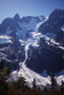
Mt. Shuksan, Price Glacier
By: Larry Sverdrup | Climbers: Larry Sverdrup, Bill Foote |Trip Dates: July 18-21, 2003
Photo: Gary Clark
® The author(s) and naclassics.com | ![]() Back to climb page
Back to climb page ![]() NAC Home page
NAC Home page
|
|
Mt. Shuksan, Price Glacier By: Larry Sverdrup | Climbers: Larry Sverdrup, Bill Foote |Trip Dates: July 18-21, 2003 |
|
Photo: Gary Clark |
® The author(s) and naclassics.com | |
|
This was my third attempt to climb mount Shuksan via the Price Glacier route, one of the "Fifty Classic Climbs of North America" since it is listed in the notorious book with the same name. I have now climbed more than half of the "50-classics" and I have to say that the Price Glacier route is one of the wildest and most beautiful climbs I have done. The journey is long, the scenery is spectacular and unrelenting, and the climbing is a blast. There is, however, a small chance that you could find yourself scrambling to dodge a falling rock or a few massive blocks of ice, assuming of course that visibility was adequate to permit a decision as to which way to run. Luckily most of the exposure is limited to the crossing of two relatively narrow gullies. In the United States outside of Alaska, Mt. Shuksan is the most heavily glaciated mountain that is not a volcano. According to the 50-classic book, it is also the most photographed mountain in the world, and you'll see why if you climb it. Since the upper Price Glacier is continuously changing, there is no fixed route per se, or even a guarantee that a reasonable route exists. But that is part of the adventure. On Thursday July 17th Bill and I flew into Seattle and rented a car. Bill brought a stove but of course no fuel on the airplane, so we made a quick stop to purchase fuel at REI. REI is easily visible from I5 in Seattle, and thankfully they were open past 9pm. The best way to obtain water on the upper mountain is to melt snow. We drove to near the town of Glacier and bivied on a side road. Bill was awakened by an animal licking his face, and momentarily considered whether or not it could be a bear. It turned out to be a dog. We registered at the Ranger station in Glacier, and gathered what limited information was available. The weather was looking good. Since the Nooksack Cirque trailhead is not patrolled, an "adventure" pass was not required for the car. In anticipation of success, Bill purchased a copy of Lee Mann's "Icy Wilderness" poster, featuring the Price Glacier in its full glory. From the town of Glacier we continued on Highway 542, heading up towards the Mount Baker ski lodge. Just before a bridge crossing the Nooksack River we turned left onto a dirt road. A sign now states that this is the way to the Nooksack Cirque trailhead. Shortly the road branches, and we took the second right following the sign to Nooksack Cirque. Last year this last section of road was overgrown, and branches scraped both sides of the car. This year it was pruned well back. The road ends at a washed out bridge. We finished packing and soon we were off. The initial obstacle is a stream crossing at the washed out bridge. Someone has now trimmed the tops of logs crossing both forks of the stream, making this crossing quite simple. Once across, one simply hikes upstream to regain the road. A few years ago, at some point on the trail an old bridge had decayed and one had to climb down the bank into the drainage, and then back up the other side. This bridge has now been replaced with a new one. When the trees suddenly get much larger and a wilderness sign appears, it is time to leave the trail and drop down to the Nooksack River. There is a fallen tree crossing the river slightly upstream from where Price creek merges with it. The tree is the crossing. If you descend right after the wilderness sign on a faint trail, you must eventually work upstream a short ways to reach the log crossing. It is best not to go all of the way down to the stream, but to stay on a bench slightly above it as you work upstream. The crossing is a bit of an eye opener, as the water is fast, cold and deep. The log itself is well over a body length above the rushing water. A fall into the river from that height, especially with a pack on, would be serious. And it's not like your friends could run along the banks to fish you out, the foliage is much too dense to allow that. There are two ways to die on the hike in. This is the first. I think that I made the mistake of looking at the water the first time that I crossed the log. Sometimes called the "waterfall effect," your brain likes to eliminate constant sensory inputs. If you stare at the rushing water, and then look at something that is not moving, it appears to move in the opposite direction. It is easy to get disoriented that way, so my advice is not to stare at the rushing water, just focus on the far end of the log. I used the butt slide method, with my legs around the log. The bark is starting to come off, but the friction is good, even when the log is wet. However, there are some minor gymnastics required to get around a branch about three-quarters of the way across. My partner on my first two trips into Nooksack Cirque, Tom Cowen, walked across the log standing up. In my three trips to do this route, I have met several other parties hiking in to play on Nooksack Tower. In all cases, the unmarried climbing jocks walked across the log standing up, while the married-with-kids people like me did the butt slide. One penalty for retreating from Price Glacier is that you will have to cross the log again. After crossing the River, one heads up and left along Price Creek. The first time I did this we headed straight up left from the stream crossing and found ourselves mired in dense foliage and fallen logs. The right way to go is head straight back to Price Creek (parallel to the log crossing) and only then turn left to head uphill, following at times an often faint but sometimes quite good trail. The trail gets steep occasionally, and especially if wet you will find yourself grabbing roots and branches. I wondered if anyone had ever taken the fast way down in a Cascade drizzle. There are alternate trails, but basically the route parallels Price Creek all of the way up to Price Lake. On my first hike in I looked down at one point and was aghast to find that I was standing a mere foot from the edge of a cliff perhaps 80 feet down to the rushing water of Price Creek. The knee-high foliage camouflaged this. This one short exposed section is avoidable by taking a higher branch of the trail. Slipping on wet terrain and falling off the cliff into Price Creek is the second way to die on the hike in. Eventually the terrain levels off and a moraine is reached which curls around and above the northeast side of Price Lake. Above the moraine, the trail continues around the right hand side of a developing ridge, but soon fades away. The first time in we decided that the traverse around the ridge was getting a bit steep and unpleasant and ended up groping our way to the top of the ridge by grabbing handfuls of grass. The next two times we climbed up the end of the ridge after the moraine ends. This is a bit steep and unpleasant at first, but once on top of the ridge the way is easy. There are puddles of water from melting snow on top of the ridge from which one can pump water. One party told us that they had never taken the top of the ridge, so the right hand side does go. Theoretically one could stay on top of the ridge all of the way. However, just before the ridge bends right a section with a pesky rock move is encountered. At this point we dropped down to the right and onto a snowfield. From here on the way is mostly snow covered. A snow gully is climbed to regain the ridge. After climbing upwards on the snow covered ridge top for some time, the ridge dips down to a saddle featuring some nice rock ledges that make a great bivy spot. There is access to the glacier from this spot. Water is available in puddles formed from melting snow. There is no higher source of liquid water to my knowledge. There is a higher saddle forming a prominent snow notch on the ridge. However, from there one would have to lose altitude descending to the glacier. From the bivy spot one occasionally hears thunderous crashes as ice calves off of the bottom of the glaciers and heads toward Price Lake. You don't have to take an Alaskan cruise to see this happen. The sound adds to the atmosphere of the place, from which one can survey the upper Price Glacier. It was on my second trip here that I first realized that there was a massive hanging glacier to the left of the exit gully on the upper right portion of the glacier. Massive ice blocks from this hanging glacier had at some earlier time fallen down, scouring and raking the glacier below. I was so frightened by the prospect of climbing underneath that monster that on my second trip in I decided to bail and instead climb a safer route to the summit. My plan was to finish climbing the ridge we were on, and drop down onto the glacier behind Nooksack Tower, following it to the summit plateau. We climbed to near the end of the ridge, at one point using some rock pro. From there we could indeed make it down to the glacier behind Nooksack, but we also realized that the glacier at this point was such a maze of crevasses that we would need a ladder to make it through, and we retreated. In my three trips in to climb Price, I had to admit that I had never (with one possible exception) witnessed anything sizable falling from the upper portions of the glacier. The one exception was on the second trip, when just after making such a remark, something massive fell from fairly high up. The thunderous crashes took a considerable time to reach the lake. We couldn't tell if it fell from above the climbing route or not because at the time there was a total whiteout on the glacier. The point is, large things falling from the upper glacier are rare. Furthermore, it becomes apparent that most things that do fall from high up get funneled down one of two gullies, one on the near side of the upper Price, and one on the far side. If these gullies are crossed quickly, exposure to falling debris is limited. My initial thinking was that the second gully could be crossed quite high, avoiding exposure to everything but the hanging glacier. I also thought that exposure to the hanging glacier guarding the exit chute could be avoided by climbing a rock ridge to its left. Also, it appeared from the bivy site that there were at least two continuous bands of snow & ice terrain that crossed the Price Glacier from left to right fairly high up. We dubbed them "superhighways" and our aim was to get on one of them and then head right. All of these ideas later proved to be worthless. We filled our water bottles including extra capacity that we had brought, and hunkered down on our luxurious flat and dry bivy site. Early the next morning we packed up and headed down to the glacier, only 20 yards below. We belayed each other down a snow tongue that reached up to the rock and were soon hiking on the moderate slopes of the glacier below Nooksack Tower. To warm up, we placed snow pickets on the initial steeper portion, but soon the terrain was so mild that we dispensed with the running protection. I was glad to have anti-snow plates on my crampons. In the generally wetter Cascade snow, balling up of the crampons can be a real problem. We passed underneath Nooksack Tower. The snow filled gully leading up to the rock climbing on Nooksack is actually quite steep. The previous year I watched a guy soloing it and he looked pretty spectacular up there placing his two ice tools. We navigated a few crevasses and approached the prominent notch separating the upper Price Glacier from the glacier below Nooksack Tower. Two years ago Tom and I climbed steep snow all of the way to the notch, placing snow pickets for running protection. This year the snow was inadequate for this, and a rock band would have to be climbed. We had an informal agreement that I would lead the rock, and Bill the more difficult ice, subject to renegotiation of course. I scrambled up the rock on my crampons wondering if they would skate or bite the rock, and set up a belay with two pieces of rock pro. We had brought a light rock rack and a selection of pitons for this. I belayed Bill who then made it back onto snow, and soon we were at the notch. Despite the forecast of good weather, there were prominent bands of cirrus clouds at times, suggesting a change in weather. I remember two years ago when I first climbed to the notch. I was thinking that we were doing some stuff on the lower glacier, and then you take a look at the upper Price and your jaw drops. You realize that you haven't done anything yet. The upper Price is the real McCoy, and not for the faint of heart. The terrain is quite steep with jumbled ice blocks and crevasses everywhere. There are cliffs of hanging ice high up above the notch and over by the exit gully on the far side. All of the snow on the upper reaches of the glacier is fluted or vertically streaked from falling debris. There were several cornices around the upper rim. Lots of fallen rock is visible below the exit gully. Occasional rocks fall from near the ice cliffs above the notch as you stand there watching. However, these did not make it to our level, falling instead into a crevasse or moat above us. The notch itself is safe from falling rock and ice, and would make an interesting bivy site. The gully down which most ice and rock would fall if it did make it to our level is quite narrow, and we reckoned that we could cross it very quickly. It is only 50 yards or so from the notch. The last time I was here we retreated in worsening weather and were enveloped in pea soup fog and light rain. To attempt to navigate the upper price in poor visibility would be quite bold. It appeared that we had better weather this time. Earlier this year two crazy skiers climbed an abbreviated version of the route in winter conditions, and skied back down. Their pictures on the Web are quite cool. From the notch they climbed straight up to get above the crevasses and ice cliffs. From there they then traversed right above the carnage, eventually ascending steep terrain to top out far left of the original 50-classic route. Their route does avoid exposure to all of the major hanging glaciers. However, it was not clear to us that their route went in summer conditions, as crevasses that were covered then were gaping voids now. Clearly we would at least have to do a major section of rock climbing of unknown difficulty to piece it together. We continuously considered attempting their route until at the notch where we opted to climb across the glacier instead. This was the decision point. I injected my brain with Novocain and headed out onto the upper Price Glacier. The gully was icy since falling debris had scoured away all of the snow. I paused to place an ice screw to be safe. But we crossed the gully fairly quickly and felt a little safer having done so. We slowly climbed up and right taking the path of least resistance, and going for snow as opposed to ice whenever possible. We carried four snow pickets and eight titanium ice screws for pro. We each climbed with one ice tool and one ice axe, both tethered to our harness. Progress was steady and we gained a significant amount of altitude as we traversed right. Because of the altitude gain on fairly steep slopes, it was clear to me that reversing the route and backing off would be a very slow and arduous task. At some point we didn't like the looks of things and back tracked a short distance. We were obligated to climb a 25-foot, steep ice wall to make it to the ramp above. Bill led it with no problems and I got a neat photograph of him climbing next to the sun with ice dust swirling down past me. It later appeared that the original path we were on may have been easier than this steep ice lead. Nearing the right hand side of the glacier we had to make a decision. We could try to battle straight up the glacier possibly encountering unknown roadblocks, or we could now easily traverse right to the "death" gully on the right hand side of the glacier. The gully at least offered a sure way across, and hopefully we would spend a minimum amount of time in it. We finally elected to take the sure way and we descended slightly as we traversed right toward the gully. Rounding a corner below a bulge of ice the gully became visible and it was clear that we had made a good decision as far as avoiding roadblocks. There were no immediate crevasses or ice walls blocking our path to the upper right hand side of the glacier. Of course, there was nothing to block falling debris, either. We would have to climb the gully a short distance in order to reach easier terrain on which we could exit to the right. Unfortunately, once again the gully was icy, as falling debris had scoured away all of the snow. Reluctantly we placed screws and slowly climbed up the left hand side gully to a point at which we could cross to the right. My calves burned from the front pointing. The muscles in my arm sometimes experienced spasms from over gripping the ice axe and ice tool, rather than hanging from the wrist loop as one is supposed to do. I was elated to finally climb out of that gully, and we took off up easier snow heading for the more moderate terrain above. A short distance later the way was blocked by a crevasse that curled across the entire width of the glacier. Luckily the end of the crevasse was a mere hundred yards to the right as we were near the right margin of the glacier. It appeared that the so-called super-highways we had been looking at were in fact very steep bands of ice, and traversing them would have been very difficult. They were also separated from one another by a series of crevasses that appeared to extend almost the entire width of the glacier. Hence climbing straight up the glacier would be folly. When we looked back at the glacier we had crossed, the chaotic scene made it appear unlikely that anyone could have made it through in a day. We out-flanked the long crevasse and were soon cruising on the upper slopes of the Price Glacier. At this point we below what a climbing party years ago referred to as the "bail chute" since it is an alternate way to reach the summit plateau that avoids the feared bergschrund at the base of the exit gully. Quite frankly it didn't look like a way to bail to me, as it was long, steep and streaked from falling debris. There wasn't actually an easy way to even get on it. That previous party also reported witnessing a massive avalanche of debris coming down this chute. We didn't want to spend a long time below it. It was getting late, and we were clearly not going to be able to tackle the exit gully before darkness. We began to look for a bivy site. I didn't want to be exposed to falling debris from the "bail" chute. There was a large amount of fallen rock below the rock band to the right of the exit gully, so it wouldn't be prudent to camp there. We settled on a spot near the moat below the edge of the bail chute, below a small cliff of ice. Anything falling from above would fly over our heads and miss us. The assumption was that the ice wall itself was stable. We stamped out platforms for our bivy and settled in. Bill fired up the stove to melt water. Due to breezes and occasional clouds, it really hadn't been as hot as I had feared. However, the periodic cirrus clouds had me worried that the weather would change for the worse. It wasn't one of my better nights of sleep. At some point during the night I heard a crash far above. Shortly thereafter I hear a thunk-thunk in the snow somewhere below us. Toward morning the clouds thickened, and a few drops of rain fell on our bivy sacks. Rain might increase the chances of falling debris. Previous parties had found the bergschrund at the base of the exit gully impassable directly, and had climbed the rock to the side. There didn't appear to be any climbable rock to the right hand side. The rock face there was essentially vertical, and the moat on the right hand side was blocked by a serac. The rock on the left hand side was far from vertical, and the assumption was that we would end up climbing that. Bill had brought single boots. I had brought double boots and planned to climb the rock portions with the inner boots. Neither of us had brought climbing shoes. I didn't want to be climbing that rock in the rain, if at all possible. We arose before sunrise after a fitful night, fearing that rain was imminent. We packed up and headed up fairly easy terrain towards the bergschrund. It became evident that even getting to the rock on the left hand side would take minor heroics. We could see the massive hanging ice blocks to the left of the rock band, and were happy to be above them. The weather improved, and it never did rain, but we were periodically in whiteout conditions. It immediately became clear to me that the best way past the schrund was to climb a serac leaning against the right hand side of the schrund. The serac appeared to top off 3 feet below the upper lip of the schrund, and featured numerous small ledges. It was only perhaps 30-feet high. By contrast, the upper side of the bergschrund morphed into a 100-foot vertical ice wall to our left. A blade of ice connected us to a narrow horizontal ramp halfway up that ice wall, which in turn connected to a tongue of snow reaching the rock to the left. I recalled that the rock that people had been climbing was in the moat to the right hand side, which was inaccessible to us. Going for the rock on the left hand side might be a blunder. Bill wasn't so sure about my assessment, as that meant he was probably going to have to lead the serac, and up to that point he was fully expecting me to lead rock. We set up a belay near the base of the serac and dropped our packs. Bill took both ice tools and led off. He placed three screws on lead and was 6 feet from the top of the serac when his tools encountered snow and became worthless. The top 6 feet of the serac was snow, not ice. Never at a loss for ideas, I suggested that Bill aid the top portion on snow pickets. Bill lowered a loop of rope and I gave him the snow pickets and slings. It worked like a charm. Soon Bill was on top hauling up our packs. He lowered the ice tools to me, and I followed. As I removed the screws I noticed that they rattled around a lot. A break in the clouds had evidently allowed the sun to melt them out to the point that they would almost slide straight out. The threads just barely caught the ice. This points out the importance of placing the screws at the proper angle. Soon I joined Bill on top of the serac. I wasn't in love with the stability of the snow on top of the serac, which was considerably overhung on the downhill side, and I soon took off, surmounting a 3-foot lip to get above the bergschrund for good. Unfortunately the terrain just above the bergschrund was ice, and my pace was slow as I placed screws. A few leads later we hit pay dirt, snow that is, and we cruised up with snow pickets. Bill noted that there might be difficulties getting from the top of the rock band to the left of the bergschrund back onto the snow and ice above it. The terrain above the bergschrund is actually quite steep, and it seemed like we were in a twilight zone of never-ending steep snow. I pity the person who has to do this when it is ice all of the way. The slope finally leveled off, and we were at the summit plateau. In foggy conditions I thought perhaps that I saw the summit pyramid, but when the fog cleared it became evident that I was looking at an ice formation 30 yards in front of me. In fact we were confronted with yet another ice wall, which was in fact the upper wall of yet another bergschrund. Far to the left we could see that this ice wall became enormous in height. However, we found an almost trivial way across slightly to the left, and soon we were above this obstacle. There were now no major difficulties between the summit and us. Our exit strategy was to descend Fisher Chimneys, which I had climbed many years ago. We flirted with the idea of descending Hanging Glacier to reach Winnie's Slide, but since we didn't know for sure that this route went, we elected to continue to the easy side of the summit pyramid, from which I presumably knew the way down. This required that we contour around the mountain, traversing terrain that on the map appeared featureless. In reality we had to maneuver around several major crevasses, losing and regaining significant amounts of altitude. Eventually we got there. The Sulfide Glacier on the easy side of the summit pyramid is relatively flat, and travel became easy. I had previously climbed the summit pyramid from this location when I did the Fisher Chimneys route. It is an easy scramble requiring no rope or protection, at least if the rock is dry. In the whiteout conditions we were currently experiencing, the summit view would have been poor. We felt behind schedule and Bill didn't feel the need to go there, so we headed down to find Hell's Highway. We saw another party in the distant fog descending the Sulfide Glacier. In anticipation of possible poor visibility we had brought a GPS with the map coordinates of major features programmed in. This led us close to Hell's Highway, but when the clouds parted for a moment, all we could see was a near vertical drop over some steep ice and we passed it by, thinking we must be mistaken. Eventually we returned, realizing that there was a more moderate snow slope adjacent to the steep drop. The descent down Hell's Highway was steep, but it wasn't suicidal. When I first climbed the Fisher Chimneys route, I had really wanted to do a harder route instead. Thus I remembered the route as an easy consolation route. In fact, the Fisher Chimneys is a wild and exciting route all by itself. Now we were coming down the thing, with dim memories as a guide. We followed a trail in the snow as we crossed Hanging Glacier. Basically one heads toward the rock on the far side of Hanging Glacier, staying high to avoid crevasse fields. Near the rock on the far side, one avoids crevasses and descends till the terrain becomes icy. At that point one bails to the rock, descending a short distance on the rock to a snowy notch above Winnie's Slide. From here one can descend on the rock in what is an upper variation of the Fisher Chimneys, but the way becomes a bit dicey lower down. Instead, a possibly saner approach is to descend from the notch on snow down Winnie's Slide for a ways. However, the beginning of the snow descent looks so improbable from above that we initially avoided it. Eventually we saw the footprints going right over the edge and we gingerly followed them. Although very steep, the snow is soft and deep. We self belayed with our ice axes, but we also threw in a few pickets near the top. It helps to have climbed up this thing earlier in the day, so you know what to expect. If one fell, the run out isn't bad, and one is protected from sliding down the entire mountain by a rock band below. After descending the short steep slope, a few bands of rock are crossed to reach a series of notches in the ridge featuring cairns. The Fisher Chimneys begin at these cairns. The trail is not difficult to follow in daylight, but could not be recommended in the dark. One section is exposed, the footing suspect, and handholds are necessary for security. At some point a trail from the upper Fisher Chimneys joins the lower variation. As darkness fell we reached a snowfield at the end of the difficulties and set up to bivy in the moat. We melted snow for water, but we could have filtered water at several locations on the Fisher Chimneys descent. The moat was rocky and sloped, but it was my best night of sleep on the trip. Climbers coming up the snowfield awakened us early the next morning, and soon we were descending. Mount Baker was glowing in the morning sun above Lake Ann. We cruised down past the lake and not long afterwards found ourselves hiking upwards. The Lake Ann trailhead is near a ski lodge, and one actually has to climb up to it. From the trailhead I thumbed a ride and Bill took it back down to our car at the Nooksack Cirque trailhead while I reclined on the packs. Snow patches decorated the green hillsides all around the trailhead. As we drove out, we paused to take a few photos at a pond with spectacular views of Mount Shuksan. We had literally circumnavigated the mountain in the last four days. Bill has climbed two routes on Denali, and he thought that the Price Glacier was the most difficult and memorable route that he had ever done. One of the cool things about doing such a big route is that you feel so alive afterwards. Very much alive we were. Editor's Note: The author is a Major Contributor to the North American Classics project. |