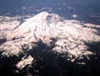
Mt. Rainier, Liberty Ridge
By: Jason Halladay | Climbers: Jason Halladay, Bill Geist |Trip Dates: May 30, 2004
Photo: Gary Clark
® The author(s) and naclassics.com | ![]() Back to climb page
Back to climb page ![]() NAC Home page
NAC Home page
|
|
Mt. Rainier, Liberty Ridge By: Jason Halladay | Climbers: Jason Halladay, Bill Geist |Trip Dates: May 30, 2004 |
|
Photo: Gary Clark |
® The author(s) and naclassics.com | |
|
At 14,410 feet, Mount Rainier looms over the Seattle area. Bill Geist and I had climbed Mount Rainier in 2002 with 3 others via the Emmons glacier. We wanted to return and climb the aesthetic Liberty Ridge route. 50 to 60 degree ice and snow on a very exposed ridge about sums up this route. It would test us probably more than any other route on any other mountain to date and we were looking forward to climbing a challenging and titillating route. We were excited for the opportunity and managed to get a great weather window for 49 hours that allowed us to climb this great ridge route. Sunday, May 30th: We arrived at the White River Ranger Station around 2 p.m. on Sunday under overcast skies. Two climbers we met there had just returned from an attempt on Liberty Ridge, but only got as far as Curtis Ridge when weather forced them back. The ranger was only aware of one other team to summit Liberty Cap via Liberty Ridge this season. He quizzed us about our experience and previous climb on Rainier, took our $30 each for climbing passes and gave us our reservation form for a camp at Glacier Basin Sunday night, Thumb Rock Monday night and Camp Schurman Tuesday night. We packed up our goods in the parking lot of the ranger station and got ready to depart. The weather forecast was for clearing on Monday with a weak system coming through on Tuesday before more clearing on Wednesday. We liked our odds and left the White River campground trailhead (4,400 feet) to Glacier Basin at 4:30pm on Sunday afternoon. After a three-mile, 1.5 hour hike approach to Glacier Basin (6,000 feet), we set up camp for the night. We chatted with a neighboring tent occupant, Chris, about his plans to accompany a guided group up the Emmons in a couple of days time. Monday, May 31st: It snowed a half inch overnight in Glacier Basin. We awoke at 6:30am under a mostly cloudy sky and left for the ascent of St. Elmo's Pass (7,400 feet) at 7:30am. We did a bit of post-holing in old boot tracks filled with new snow up St. Elmo's Pass, reaching the pass around 8:30am. At the top of the pass we had our first view of the lower Winthrop Glacier to the west. We would descend to the Winthrop, traverse across it at about 7,200 feet over to Curtis Ridge before dropping onto the Carbon Glacier. Cruising across the first part of the Winthrop was no problem. We did not find any tracks descending from St. Elmo's Pass so we were on our own breaking trail on the well consolidated snow. We roped up right away as we could see depressions in the glacier signifying underlying crevasses. From St. Elmo's Pass across the Winthrop and over Curtis Ridge we were breaking trail in intermittent whiteout conditions. Clouds would dissipate for a few minutes at a time allowing us to get our bearing towards Curtis Ridge. The traverse from St. Elmos Pass to Curtis Ridge took a bit longer than expected given the poor visibility and trail breaking but we finally arrived at the Curtis Ridge at 7,200 feet at 11:40am. We then descended onto the Carbon Glacier and began ascending the glacier to the base of the Liberty Ridge route. Thankfully we stumbled upon some fresh tracks up the Carbon that seemed to be right on track. This was a godsend as the whiteout conditions on the glacier would have made routefinding very difficult and slow. The ranger we spoke to Sunday had mentioned a guided IMG group of six ahead of us and based on the accuracy of these tracks we were following, we were sure the tracks belonged to the IMG group. At 12:45pm we had closed in on the upper end of the Carbon and the clouds broke allowing us a view of the ridge for the first time. We also noticed the tracks we had been following going up and over the rise in the glacier and then returning. We guessed the group had gone up the "normal" route of the upper Carbon glacier but got stymied by crevasses and had to turn back and try another route. Going on this hunch we just followed the fresher tracks to the right (west side) of the Carbon. A few minutes later we came across the IMG group setting up camp on the Carbon just below Liberty Ridge. They had had enough for the day and the predicted weather system for Tuesday was concerning them. We chatted briefly with the two guides and thanked them for the wonderful boot track up the Carbon. They quizzed us about our preparedness and plans for the ridge. We told them we had fuel and food enough to spend a couple days at Thumb Rock camp on the ridge if necessary. We bid them a good climb and continued on up to the upper reaches of the Carbon Glacier. We found the upper Carbon Glacier to be heavily crevassed and could find only one decent looking snow bridge between a 60-foot-deep crevasse system that led to Liberty Ridge. Taking a deep breath I cautiously worked my way across the bridge as Bill played out rope. One more short snow bridge crossing after that and we were staring up at the east side of Liberty Ridge looking for a way to gain the crest of the ridge. Lacking any other obvious options, we opted for a ugly snow/rock slope to gain the ridge proper. A recent rockfall/wet snow slide had left quite a skid mark down the ridge's east side. This sketchy snow to sketchier rock line got us to the ridge proper. Bill led out and up this section. Around 3:00pm we gained the true ridge and began ascending Liberty Ridge's right (west) side towards Thumb Rock. Thumb Rock is a major landmark on the ridge at about 10,600 feet offering about the only level spot for bivying on the entire ridge. The snow was solid on the west side and afforded us some quick movement upwards. We actually ended up crossing over the ridge to the east side for a couple of short sections but found wind-loaded, knee-deep snow, so it was back to the west side of the ridge including some rock scrambling directly on top of the ridge. On Liberty Ridge's crest above the clouds in perfect weather around 4:15pm, we enjoyed some fun and aesthetic climbing indeed! The ridge's angle never exceeded 35-40 degrees on this lower section below Thumb Rock. Just below Thumb Rock at 5:05pm we opted for the rock/dirt traverse on the west side to gain the campsite just above Thumb Rock. A little digging renovated an old tent platform for us to pitch the tent under clearing skies. We began the snow melting process and filled up my 3-liter hydrosack, my one-liter bottle and Bill's 2 one-liter bottles before making dinner. The day had been a big success for us, ascending 4600 vertical feet from Glacier Basin to Thumb Rock in ten hours. The weather appeared to be clearing and staying stable. We were in good spirits. Our plan was to awake at 3am, take a look at the weather and head for the summit if it was clear. We dined in the tent on freeze-dried spaghetti with melted cheddar cheese. Man that was some delicious spaghetti. Right around 9pm the sun set below the sea of clouds making for a truly awesome sunset. The wind died down a bit and was only intermittent throughout the night. The camp at Thumb Rock is one of the best camps I've ever had. As far as the view is concerned, it ranks right up there with the Lower Saddle camp on the Grand Teton. Tuesday, June 1st: We woke at 3am to a perfectly clear sky with the lights of Seattle and the Puget Sound to the northwest. We packed up camp and set off up the ridge at 4:30am. From Thumb Rock climbers have three options for gaining the ridge above the rock face behind camp. The left face (east side) promised to be more deep snow wallowing so we skipped that idea. The center gully involved a 15-foot ice pitch at about 80 degrees so we skipped that as well. We ended up going right around the rock which turned out to be quite nice; good step kicking in relatively good snow for about an hour up to 11,500 or so. We began to run into some glare ice at this point and each pulled out a second ice tool. Up to this point the single alpine ice axe had been sufficient but as the route steepened and the snow turned to a more icy surface, it was very nice to have the comfort of a second tool. We only ran into a few short sections of true water ice along the route. Just below the Black Pyramid at around 12,000 feet I stopped to belay Bill up to a rock outcropping for a much needed break. After this the angle steepened to about 55 degrees going around the Black Pyramid on the east side of the ridge. We were no longer able to penetrate the snow/ice surface much and began to spend a great deal of time on our front points. While not difficult, it was quite pumpy on the calve muscles to spend ~1300 vertical feet on the front points. Around 13,200 feet we stopped to rest and then Bill lead off for the bergschrund. We headed for the left side of the bergschrund near almost straight up the ridgeline. We could make out away to move left around a vertical ice wall at the schrund and take steeper snow/ice to the slope above. At the bergschrund Bill placed our first piece of protection, an ice screw. We topped out on Liberty Cap around 10:45am. Looking across from Liberty Cap to Columbia Crest, Rainier's true summit, we saw a nice lenticular cloud enclosing the summit. We opted not to go to the true summit. Rather than ascending anymore than we had to before descending the Emmons/Winthrop Glaciers to Camp Schurman, we headed down from the saddle between Liberty Cap and Columbia Cap between the two glaciers. This worked well until we became "crevassed out" and had to improvise a short crevasse crossing to gain the wanded route down the Emmons Glacier. We did a good bit of postholing down to Schurman as it was a warm afternoon. We arrived at a deserted Camp Schurman at 1:45pm. It began snowing lightly and the winds picked up on the summit. Our timing had been just right. With plenty of daylight left in the day, we loaded up and headed out towards the car at the White River CG. Descending the Interglacier at 2:30pm was a bit brutal with some major postholing., but with beer on our minds, we trudged on purposefully and arrived back at the car at 5pm. Pizza and beer were located at a restaurant in nearby Packwood, WA. Postscript: Two days later we heard the news of John Cahill falling and dying on Liberty Ridge. We are quite somber to hear this news and our thoughts go out to his family. |