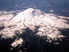
Mt. Rainier, Liberty Ridge
By: Doug Artman | Climbers: Doug Artman, Randy Howell |Trip Dates: May 30-June 2, 2001
Photo: Gary Clark
® The author(s) and naclassics.com | ![]() Back to climb page
Back to climb page ![]() NAC Home page
NAC Home page
|
|
Mt. Rainier, Liberty Ridge By: Doug Artman | Climbers: Doug Artman, Randy Howell |Trip Dates: May 30-June 2, 2001 |
|
Photo: Gary Clark |
® The author(s) and naclassics.com | |
|
May 30: After a long 20 hour non-stop drive from Southern California where my partner Randy lives, we arrive at the White River ranger station in Mt. Rainier National Park around 10 AM to obtain permits for our climb of Liberty Ridge. Liberty Ridge is a grade IV climb on the north side of Mt. Rainier just west of the Willis Wall. I had wanted to do this climb for years but had not been able to find a partner competent enough to attempt it with me. Randy and I have been climbing together for several years now and felt secure in each others' abilities. When we arrived at the ranger station there were news crews all standing around. We didn't know what the fuss was all about but as we registered for our climb the rangers told us that a rescue was in progress on our intended route. Apparently a party had been hit by an avalanche high on the route, had lost all their gear and couldn't move up or down. The rangers scrutinized us and quizzed us trying to determine our preparedness; apparently satisfied, they let us go on our way. We begin the hike up the Glacier Basin trail at about noon. The weather is clearing, but the forecast is for a clear day tomorrow and then more bad weather for the next few days after that. The views along the trail are of Little Tahoma Peak, and then as you pull into Glacier Basin you can look up the Inter Glacier towards Steamboat Prow which will be our exit route in a few days. From Glacier Basin the route ascends up over St. Elmo pass and drops down onto the Winthrop Glacier where we rope up for the glacier crossing. The Winthrop is somewhat broken up but not really too bad. We make it across the glacier then onto lower Curtis Ridge. Continuing a traverse west across the broad and seemingly unending slopes of the ridge, we finally reach camp at the edge of the Carbon Glacier and call it a day. Obtaining water here is somewhat of a problem, with the only source of water a small snow patch several hundred yards from camp. May 31: The Carbon Glacier can sometimes be a major factor in the success or failure of climbing Liberty Ridge. This time it provides a very direct route to the lower west side of the ridge. Gaining the ridge is somewhat like walking down the middle of the lanes in a bowling alley due to rock fall. We climb to the crest of the ridge low, thereby avoiding some of the rock fall further up the route. We had taken off our crampons for the majority of the route but several hundred feet below Thumb Rock, our high camp for the night, we are forced to put them back on to negotiate some steep ice. At the top of the ice, our camp provides incredible views out across the Willis Wall and down across the Carbon glacier. The weather had been perfect this day and we lounged around camp soaking up the sun the rest of the afternoon. In the meantime two brothers arrive at the camp and we chat for a while. They are planning to leave by 2:00 AM, climb the route and descend all the way to the parking lot in one long day tomorrow. June 1: I hear lots of rustling around from the brothers but it is late, 3:45 AM. We are even later and don't get moving until 6:00 AM. It also looks like the weather is beginning to move in on us. We elect not to take the chute out from Thumb Rock, because the snow is pretty much gone. Instead, we head out on the snow slopes to the east and make quick progress on easy firm snow underlain with ice. We continue simul-climbing for a couple thousand feet without putting in any anchors. Finally we begin to encounter steeper alpine ice and start running belays with one piece between us. We leap frog up fairly quickly and pass the two brothers who started a couple hours ahead of us. A couple hundred feet below Liberty Cap the ice gets seriously steep and soon we are directly below the ice cliffs leading to the upper slopes of Liberty Cap. I'm glad it is Randy's turn to lead this section and I pass the gear to him. He starts up the ice but backs down. We futz around seeking an alternative route for a while until I finally take the rack and head back for the cliff. I take a slightly different line and eventually the rope comes tight and Randy starts up after me. We are still simul-climbing using only one piece between us. This ice begins to turn very cruddy and I'm having a difficult time making progress but progress it is. Had the weather been better I would be really enjoying this, but by now it is very windy and snowing. The climbing is stimulating with bad ice and vertical steps between loose snow-filled slots. At this point Randy is below me and I am trying to push through one of these loose snow areas when I start to break through a bridge. I slap a tool into the ice over my head as I inevitably break through and am left hanging by my tool. The snow fills in around my legs so it takes me awhile to get free and regain firm footing. When I can see Randy again I yell down to him "I fell in a hole." His response is, "Oh is that what was taking so long?" He is freezing and wants to get moving. I continue up and finally pull over onto Liberty Cap glacier. The wind is really howling as I set up a belay and bring Randy up. He grabs the gear and we keep moving. The slopes we are climbing now are continually raked by small powder snow slides, so it's not a good place to linger. Finally the slopes are backing off and we are just below the summit of Liberty Cap. It seems somewhat protected from the wind here and we are free of the avalanche hazard. We decide to set up the tent and descend the Emmons route in the morning. No sooner is the tent set up than the wind becomes absolutely ferocious. The tent doesn't last 10 minutes before it shreds in the winds. We spend the rest of that night huddled under the flapping piece of nylon trying to keep from getting frostbite. June 2: The wind is still howling but we are anxious to move out of here, so we load up and are on our way. Randy leads off today and very soon we crest out on Liberty Cap. The whiteout isn't total and we are able to pick out a way down to the Emmons route intermittently between the flurries. I locate the route and lead the way down. Winding around and over the crevasses in near whiteout trying to avoid newly covered slots we soon are on the eastern side of the bulk of the mountain. Almost immediately the wind begins to lessen. We get off route once but not by too far and we backtrack to where we think it must go. We continue descending trying to guess where we are until finally we get a glimpse of Steamboat Prow far below. At about 12,000' we pick up the wanded route and by now there is almost no wind. What a relief! We stumble back down to camp Shurman where the rangers meet us. They were a bit concerned for us and are glad to see us down safely. However we haven't seen the brothers since late yesterday afternoon. The rangers ask about them and we told them they seemed competent and we last saw them at about 13,000'. The rangers top off our water for us and we continue down toward the parking lot arriving that afternoon. Stopping by the White River Ranger station to check out, we ask about the brothers, and learn that someone may have talked to them on the Emmons side of the mountain which is good news. |