|
Waitin' On a Sunny Day
I arrived at the belay in a state of confusion. The clouds were so thick
I could only see clearly 20 to 30 feet in any direction. I could make
out rough shapes as far as 100 feet, but all else was a damp fog. Midway
through the pitch, I was able to make out the blurry silhouette of a steep
ramp extending upwards into the haze, presumably to the summit. But at
the moment all I could see was the distant outline of a massive gendarme,
overhanging steeply to the south, snow-plastered to the north, blocking
all progress.
Or was the gendarme merely a tiny block, only several feet ahead? It was
utterly impossible to determine scale in these conditions. Depth perception
led simply to deception. The swirling mist obscured all detail, and made
the few visible objects unidentifiable.
As I joined my companions, a debate ensued. Was the large gendarme in
front of us the summit, or was it merely the next obstacle in a seemingly
unending roller coaster ride of ups and downs, steep buttresses and knife-edge
ridges, gendarmes and pinnacles, tension traverses and rappels?
My altimeter measured 8,950-just 122 feet shy of the summit-and we had
climbed two long pitches since passing a prominent notch, with numerous
slings, that was surely the "rappel notch." The only evidence
we had to refute the claim that the summit was within reach was a dreamlike
image of a stairway to heaven that we had all seen from lower on the pitch.
From our current vantage point the mirage was completely obscured by the
ambiguous gendarme to the west. As the discussion continued it became
impossible to know for sure if I had seen the murky stairway at all.
Every concrete piece of evidence seemed to indicate that we were just
below the summit, but we were unable to shake the image from our collective
consciousness. Somehow we knew. We all knew; the mountain had trained
us. Every time we thought the way was getting easier, the mountain threw
another obstacle in out path, each more difficult and improbable than
the last. Although we could hardly see the ridge, we knew the remaining
climb, no matter how long or how short, would not be easy, and would undoubtedly
require far more time than we anticipated.
It was 6pm. The weather had been steadily worsening all day, and it
appeared as though the trend would continue. Although we were unable to
agree as to our exact location along the ridge, we came to a consensus
that if we didn't retreat immediately we would be spending the night on
the mountain.
The four of us met in Seattle on the evening of July 16th. After a brief
stroll along the waterfront and a meal of crab legs, oysters, and other
assorted sea creatures, we headed for bed, anxious for the next day's
activities. In the morning we departed for the North. Quick layovers in
Ketchikan and Wrangell brought us to the sleepy fishing community of Petersburg,
Alaska. The TEMSCO Helicopter hanger was only a few hundred feet from
the Alaska Airlines terminal, so we drug our enormous bags over and awaited
the return of our pilot. Wally arrived via helicopter shortly after. He
had been on a contract job for the local Forest Service office, which,
in addition to work for the city, state, various timber operations, ATT,
and the summer cruise line tourists, is how TEMSCO typically pays the
bills. Wally brought out a map and filled us in on a little history. Generally
speaking, it rains all the time in Petersburg and the surrounding mountains.
It's not unusual for climbers to sit in Petersburg for many days, in one
particular case 10 days, waiting for sufficiently good weather for the
20-minute helicopter flight to the Thumb. Likewise, it's not unusual to
wait for days or weeks for a trip back, once the climbing has been finished.
Wally was quite adamant that we have a firm plan for how we would hike
out to the Baird Glacier, should that become necessary.
It was apparent by mid afternoon that we would not be flying in that day.
Wally called around and got us a room at a Bed 'n' Breakfast in town,
and we headed out to take in the sights and do some last minute shopping.
Like most mornings in Petersburg, Thursday dawned damp and dreary. We
packed our things and headed towards the hanger to check in with Wally.
Two guests who shared the BnB drove us to a grocery store near the edge
of town, only a short walk from the airfield. Unfortunately the store
lacked the one item on our list, white gas, so we all walked back into
town. We found the gas at a local variety store on "main" street.
Once we had dropped our supplies at the hanger, we headed back into town
for some lunch.
The Northern Lights bar and grill had caught our attention the previous
day, so we headed there. It is surprisingly difficult to get good seafood
in Petersburg. Apparently everyone is a fisherman, so they don't go out
to restaurants to get seafood. If they want seafood, they get in their
boat and go get some straight from the source. Midway through my pineapple
burger Mike got a call on his cell phone from Linda, the TEMSCO secretary.
In typical style, Mike hung up when the conversation was over and sat
quietly, waiting for the rest of us to burst with anticipation. Amid threats
of bodily harm, Mike finally informed us that the weather was clear up
by the Thumb, and Wally would be available to fly us up in 30 minutes.
Marc and I dropped our burgers in mid bite and burst out of the restaurant,
literally running to the hanger. We were at least a 20-minute walk from
the hanger, and we still had to get dressed. Its bad form to leave your
bush pilot waiting.
I made a slight detour on our way to the hanger to drop several postcards
in the mail. We arrived at the hanger early, and dripping with sweat.
Marc and I stripped to our shorts, hoping to cool off a little before
we dawned our arctic outfits. For some reason, perhaps the constant rain,
mosquitoes and other carnivorous bugs are scarce around town. Marc and
I readied ourselves as much as possible without actually getting dressed,
and waited anxiously for Wally's arrival. Just then Mike and Janelle casually
strolled in, having finished their lunch, paid the bill, and leisurely
walked towards the airfield, even stopping along the way to purchase our
perishable groceries.
Wally arrived and gave us a quick briefing on the aircraft, entry and
exit procedures and safety equipment. The Hughes 500 will comfortably
carry up to 550 lbs of payload, including passengers and equipment, and
still have enough power to land at 6,000 feet. Since there were four of
us, and we had enough equipment to siege El Cap, Denali, or the Grand
Central Couloir, Wally would have to make two trips. Marc and I would
go first, Janelle and Mike second.
The flight to the Thumb was breathtaking, and in some ways, the highlight
of the trip. We certainly saw more scenery during the 20 minutes on the
helicopter than during the entire time spent on the ice cap. Wally flew
us directly towards the Thumb, which was not visible from town. We headed
up the Patterson Glacier and over a high, serrated ridge. Beyond the ridge
the landscape dipped 4000 feet into the notorious Witches Cauldron. Devil's
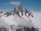
Thumb juts out 7,000 vertical feet from this basin. There are no photos
that illustrate the immensity of the Thumb, and the tremendous vertical
relief is difficult to comprehend. The first 4000 feet from the glacier
consist of very steep granite slabs, followed by a brief interlude of
jumbled ice and snow, before the upper Devil's Thumb massif, with its
sheer south face, flanked by the Fox Head and Cat's Ears spire elegantly
piercing the sky.
Wally's helicopter climbed quickly up the massive 4000-foot icefall that
marks the terminus of the southeast fork of the Witches Cauldron. As we
glided around the SE slopes, the Thumb revealed Mt Burkett and the astonishing
Burkett Needle to the northeast. To the Southeast cloud cover obscured
the highest peak in the Stikine Ice Cap region, 10,000-foot Kate's Needle.
Wally swung his helicopter around, searching for some contrast in the
enormous blanket of snow below. Landing a helicopter on an ice field is
a delicate art. Everything is white, making it extremely difficult to
judge distance, and impossible to determine terrain gradients. Wally located
a small snow hump, whose shadow betrayed its size and shape. He slowly
lowered toward the plateau, eyeing the aircraft's shadow as it became
larger. Wally lightly tapped the surface, then slid slowly across the
hump to make a short track for his return trip. Once he had settled on
a spot, he bounced slightly on the snow, to ensure the mound would not
collapse into a gaping crevasse.
Marc and I jumped out of the helicopter, removed our gear, and ran MASH-style
away from the bird. Once we had reached a safe distance we dropped to
one knee and waved as Wally headed back to civilization for the others.
On the ground the landscape takes on a completely different appearance.
Scale cannot be judged at all from the air. Mountains always seem tiny
and routes appear much easier than expected through the window of an aircraft.
The ice field grew to several times its original size as our minds adjusted
to this new perspective.
Marc and I made a quick survey of the area, hoping to pick out a possible
site for our base camp. The serious task of locating shelter soon took
a backseat to the less serious but more enjoyable task of getting a good
look at the Thumb and our intended route before the clouds moved in. We
roped up quickly and headed west toward a small rock fall protruding south
from the lower slopes of the East Ridge. Two hundred yards of easy walking
brought us to the top of the rock fall, which was also the bottom of a
quarter-mile-long spur ridge branching south from the lower East Ridge.
From this point we were able to see the entire Southeast face of the peak,
and the Direct East Ridge was evident in profile. Having spent many an
expedition day stranded in vast seas of endless snow and ice fields, I
proposed that this spot, nestled against a gently rising granite ridge,
with tiny streams of water trickling off nearby rocks, would make an excellent
base camp.
As the notion was gaining ground, Marc heard the high pitch whine of Wally's
helicopter. Much to our astonishment, Wally had already returned with
Mike and Janelle. Our intention was to be at the landing zone when Wally
returned, so we ran back towards the site, snowshoes flapping wildly,
as they zoomed past. Wally was able to land much quicker this time, using
our equipment and his previous tracks to judge his location. He dropped
Mike and Janelle, stepped out briefly to snap a photo of the Thumb, then
headed back for another job.
I quickly convinced Mike that I had discovered the ideal base camp, and
we began the process of shuttling our excessive bags toward the ridgeline.
After reveling briefly in our unparalleled wisdom we commenced the arduous
process of constructing an expedition style base camp. Previous accounts
of multi-day blizzards and gale force winds inspired the group to build
the walls thick and high. By 7:00pm the camp was complete, and dinner
was on the way.
The most significant difference between flying into Kahiltna Base Camp
in a Cessna then dragging all your gear 15 miles to Genet Basin, versus
taking a helicopter directly to a base camp at the base of the Devil's
Thumb is the quality of the meals. For 20 days on Denali I ate nothing
but reconstituted mush and power bars (also known as un-reconstituted
mush). For the first night on the Thumb, we enjoyed salmon steaks, mashed
potatoes, and pie.
The four of us settled into bed around 10pm, just as the light was beginning
to fade in Southeast Alaska. The plan for the morrow was to rise at 4:00
am, and be on the glacier by 5am. I felt in some way that this was an
awfully late start, but the route didn't look that hard, and we are all
pretty fast climbers.
We didn't actually start until 6:10am. Marc set out in the lead to break
trail as usual. He was our secret weapon in a number of ways. Most expeditions
were monotonous and boring, with much time spent snow slogging, or sitting
in camp, waiting for weather. With Marc along, we could be sure that no
matter how little we climbed, the trip would never be boring. It was impossible
to be in a bad mood when he was around, and the more miserable conditions
got, the more cheerful Marc became. Once the summer solstice passed, Marc
began counting the days toward winter. Whenever Marc donned his ice climbing
regalia a distinct transformation took place. He became superman; he was
unstoppable.
And Marc was an inspired hiker. His steps were twice as long, twice as
fast, and twice as strong as any person I've ever met. Like all great
naturals, Marc never trained per se, but once on the trail, he could not
be deterred. You didn't have to ask Marc to break trail. Regardless of
who set out in front, Marc would end up in the lead sooner or later whether
you wanted him there or not. Having Marc start in the lead merely simplified
logistical matters. I roped up to Marc, just to make sure he never got
too far ahead. Of course, this tactic did not slow Marc down. He just
pulled me up to match his superhuman pace.
Our plan was to climb in two teams, Marc and I in the first team, Mike
and Janelle in the second. Marc would break trail to the base of the Direct
East Ridge, at which point I would take over the lead as he and I simul-climbed
the ridge. The snow on the glacier was very soft, and we had to do quite
a bit of zig-zagging to avoid cracks. The bergschrund was as much as 40
feet across in places, but we were able to find a suitable snow bridge
near the far east edge of the glacier. Some steep snow climbing above
the 'schrund brought us to a fairly flat shoulder at the base of the ridge
at 7:45am.
Fred Beckey and companions first climbed the original East Ridge route
in 1946. The route climbs directly up the west end of the glacier to the
Hog's Back, then traverses diagonally up and right to join the East Ridge
midway toward the summit. This route is dependent on significant steep
snow climbing, and the second ascent part, British Columbia Mountaineering
Clubbers led by Dick Culbert in 1970, felt snow conditions were too dangerous
to follow the same route. In order to avoid the treacherous Hog's Back,
Culbert's party gained the East Ridge at its base, and followed steep
rock along the ridge all the way to the summit over 40 hours (including
bivouac). This "Direct East Ridge" added quite a bit of technical
rock climbing to the original route, which was primarily a snow climb
(though the original route still required 10+ pitches of very difficult
rock, ice, mixed and aid climbing). This direct start, which is in fact
quite a bit less direct than the original, incorporated two massive rock
buttresses. The direct start rejoins the original route after a short
rappel off the summit of the second buttress.
The first and second buttresses are separated at their base by a beautiful
open book crack. The first buttress could be bypassed altogether by walking
50 feet to the left and following the crack for 1-2 pitches to the notch
that separates the two buttresses. Marc was not the sort of person who
got bogged down in ticking routes off a list, and he immediately raised
the obvious question of why anyone in their right mind would climb the
first buttress, when it could so easily be avoided. I had no good answer.
However, I did have an answer. The "Direct" East Ridge was the
route in the book, and therefore the route we had to climb. Such a stark
exhibition of my shallow goals bothered me deeply.
At the base of the First Buttress we stopped to apply sunscreen and change
into our climbing shoes. From the moment we left camp we had been climbing
through light fog. But once we gained the shoulder at the base of the
ridge we popped out above the clouds. We could see the sun, and many of
the higher summits peeked out from the blanket of fog that engulfed the
ice cap. I headed straight up the steep buttress with little guidance
other than to 'stay as close as possible to the ridge crest.' The granite
was excellent, though heavily fractured. Individual blocks were of the
highest quality, but many of these blocks were held in place only by the
grace of God. I warned the others below, and trained myself to test each
hold carefully before weighting it. Gear placements were plentiful, but
the climbing was so easy I felt silly stopping. I made a point to leave
at least two pieces per rope length, and soon the angle eased to as we
neared the apex of the first buttress. A short jaunt across the summit,
followed by a short down climb, brought me to the base of the second buttress.
This obstacle appeared far more menacing than the last. The arête
itself was nearly vertical, and several small roofs could be clearly seen
above. This was surely not 5.8 simul-climbing territory. As I mulled over
a strategy, Mike appeared atop the first buttress. I asked if he could
see a possible bypass around the corner to my left (south). Mike could
see a series of terraced ledges high up to the left, but I would have
to traverse a steep section to reach them. I headed out to the left, unsure
if I was on the right track. Less than 20 feet out from the belay I came
upon an ancient, rusted fixed pin, which was very reassuring. I continued
up and to the left, where I soon reached a large mossy ledge and the end
of the difficult climbing. I stopped to belay Marc, who quickly dispatched
the pitch. From this point I headed more or less straight up in an effort
to regain the ridge. Steep but easy simul-climbing brought us back to
the ridge crest, and we were soon at the summit of the Second Buttress.
The far west end of the summit ridge ended in a vertical drop. I was unable
to locate any rappel anchor, but the terrain looked far too steep to down
climb. Marc and I tied a length of webbing around a firm block and began
rigging the rappel as Mike and Janelle summitted the second buttress.
I rappelled to a small vertical rock band adjacent to the snowfield below
the buttress. A short, stocky, twin-summitted tower blocked the ridge
directly above. Beyond this tower was yet another notch. From my position
I could see that this short tower could be quickly bypassed via snow and
rock on the left. It was also evident that the original route joins the
East Ridge at one of these two notches, though which one I could not be
certain. The others quickly rapped to my belay. We changed back into our
boots and headed out across the steep snowfield, this time with Mike and
Janelle in the lead.
Once around the tower, Mike climbed a long, wide slab that brought as
back atop the ridge. At some point along this ridge Marc and I simul-climbed
past Janelle and then Mike, who were belaying each pitch. After several
hundred feet of interesting rock and snow climbing I came to a short,
steep step in the ridge. This step was actually the upper section of an
enormous pillar that extended down nearly 50 feet to the snow below. This
pillar is the most prominent gendarme along the East Ridge, and can be
seen clearly in many photos.
I gained the base of the step. The step itself was maybe six feet high.
The southeast façade was dead vertical, with a solitary finger
sized crack near its right edge. To the right of the step was a 50-degree,
moss-covered slab that headed toward the north face. The move would be
to mantle onto this slab, then follow it to the top of the pinnacle. I
contemplated the situation for several minutes before Mike arrived. By
this time the clouds had moved back in and it was constantly misting.
Everything was wet, and a small snow patch fed drip water onto the mossy
slab. I offered the lead to Mike and climbed back down to the belay. Mike
gained my highpoint, and pondered the move as well. I was relieved when
Mike stated that there was no way he would attempt the slimy move in his
La Sportiva Makalus.
At this point the first thoughts of retreat entered our minds. The thought
of retreat is like a cancerous seed that, once planted, will grow and
grow until it prevails. The weather had seriously deteriorated, and it
was after 2:00pm. I searched my memory banks to reconcile our current
predicament with Beckey's account of the aid moves required to overcome
the crux gendarme. There was an old rappel sling at the base of the gendarme,
and I was convinced that we were in the same spot. Mike was less sure.
If the rock was dry, and the move was done in climbing shoes, it would
not be very difficult. According to the 1991 American Alpine Journal,
the entire ridge had been climbed free at 5.9, by staying directly on
the crest. Unsure if this was indeed the proper strategy, we backed up
the solitary rappel sling and prepared to rappel around the base of the
gendarme. We agreed that whether we retreated or continued, the next step
was to rappel from our current spot. We would defer a decision until the
rappel had been completed.
Mike rapped first and tried to pendulum over to a large, corniced snow
ledge that sat poised at the base of the pinnacle. Unable to gain the
ledge, Mike climbed back up to the anchor. This time Mike placed several
pieces of gear as he descended, and was able to gain the insecure ledge.
The rest of us rappelled to Mike's precarious stance. The ledge was very
large, but appeared unstable. The snowfield below was at least 70 degrees
in steepness, and the edge of the ledge was a shallow cornice of melting
snow. Mike proceeded to the left and located a potential route back up
to the ridge. The pitch was very steep, and would certainly be the most
difficult of the climb. However, there was an encouraging sling around
a block halfway up the pitch. Several blocks overhung the pitch, and melting
snowfields atop these blocks fed a steady shower of cold water down the
right side.
Mike led first. Though the climbing appeared difficult, he soon disappeared
across the horizon and shouted down that he was off belay. Janelle followed,
and I led up on my rope close on her heels. The climbing most mostly secure,
on positive holds, though very steep. The crux required a rock-over move
on very slopey holds, followed by an awkward mantle, with poor pro (of
course). The top of the pitch entered a wide chimney that offered solid
hand jams and some good stems. The pitch ended back on the ridge, 15 feet
west of the obstinate gendarme. Marc joined my belay quickly, and once
again I set out into the mist. The pitch required easy though insecure
slab climbing over wet, mossy rock. The lead terminated below a short,
steep headwall, adorned by a short length of fixed rope, a #11 hex and
half a snow picket. Mike immediately identified the picket as the missing
half of a picket we found the previous day cached near our camp, along
with a five-gallon tub of miscellaneous equipment.
The headwall sported the typical ice-water cascade that was becoming standard
on the route. Mike surmounted the obstacle by traversing underneath the
overhang to the right (north), turning an exposed corner, then leading
up a shallow ramp to a short step. Above the step, a short snowfield brought
us to a long plateau on the ridge crest. From the plateau, the silhouette
of a large gendarme was visible ahead, but little else. Once we had all
reached the belay we finally agreed to throw in the towel-at least for
today. If we turned back now, we reasoned, we would be able to make it
back to camp without a bivy. We snapped a few photos of our highpoint--just
in case-and rigged the first rappel. Five rappels later we decided to
down climb for a while. The rappels were very slow with four climbers,
and down climbing would allow us to move simultaneously and keep a little
warmer. Our strategy was to link several large, disconnected snowfields
back towards the broad shoulder at the base of the Direct East Ridge.
From this point, we could easily retrace our footsteps back to camp. Our
team persevered as the sunlight faded, placing gear as we climbed to protect
the steep, warm snow. As we descended, visibility worsened. We strained
to identify the few landmarks we could see, hoping to link the route before
the light faded completely. Just before 1:00am Mike led out across a large,
horizontal snow-patch. Fifty feet out from his last piece of gear, he
triggered a small snow slide. Previous experience on Mt Timpanogos reminded
Mike that cataclysmic, alpinist-swallowing avalanches are often preceded
by smaller warning slides. He gingerly retraced his steps back to the
relative safety of a large rock rib. We decided to bivy on the rib for
the night.
I was stunned by the decision. Sure, it seemed like the most pleasant
thing to do at the time, but I had learned over the years that the most
pleasant option is usually the least desirable from a survival standpoint.
We had one VBL sleeping bag liner between the four of us. All of our clothing,
hats, gloves and boots included, were soaked from the wet snow and mist.
I had switched to my dry "backup" pair of gloves several hours
earlier, and they were now soaked as well. My feet were already numb,
even when we were moving. We were still over 8,000 feet, on the side of
a steep, exposed slope, with no bivy gear whatsoever, in an area notorious
for inhospitable weather. Surrendering to exhaustion at this point seemed
like suicide. On the other hand, traversing the snowfield was out of the
question at the moment. The only other option was to rappel into the void,
over the horizon of the steep rock rib on which we conferred. We had no
idea where the rock rib led, or if we would be able to cross the bergschrund
at its base. Despite the uncertainties of the route below, I felt we had
to keep moving. However, my protests fell on deaf ears. As I extolled
the virtues of my plan, Marc, Janelle, and Mike dug out bivy platforms
in the rock. As the others settled in, I acquiesced; crouching down literally
in the spot I was standing. At the very least, I reassured myself, this
would be the very worst bivy of my life.
At some point during the intervening four hours, I managed to secure approximately
seven minutes of sleep. Having by far the most unpleasant stance, I arose
first, making my intention to continue at once clear to the others. My
legs and feet were completely numb from the knees down, but aside from
that, I actually felt quite a bit worse than I had when I bedded down.
Fortunately the snow had consolidated slightly during the night, and as
soon as I turned my gaze to the east I was shocked to discover the snow
shoulder, our objective during the last night's descent, was only a few
hundred yards distant. Marc set out first, and we quickly regained our
approach trail, which we followed all the way to base camp in a little
under two hours. By the time we arrived in camp, circulation had returned,
and spirits soared as we dug into our foodstuffs and dove into sleeping
bags.
The next three days were a blur of sleep, food, and fog. Whenever the
mist stopped we would all flee from the tents for a brief reprieve before
it returned. The time was passed reading novels, cooking elaborate meals,
playing hearts, listening to the transistor radio for weather reports
and philosophizing about our next attempt on the Thumb. Obviously we would
start climbing before 6 am. We would also skirt the lower ridge, retracing
our descent path back to our high point. This would require that we re-climb
the last three pitches, incidentally the three most difficult pitches,
but it would save a great deal of time and give us a better shot at the
summit.
We were very confident, sitting in the tents, that we could summit at
any time. We had learned during the previous attempt that we didn't need
perfect weather to succeed. In fact, we didn't need fair weather. We could
climb, and probably summit, in poor conditions. Thus assured of the summit,
we only had to wait for a nice day as long as our sanity would allow.
Once the moment arrived when we could take no more, we would pack our
bags and set out the very next morning, rain or shine. It turns out our
aptitude for boredom is very low indeed. Monday evening, after only two
full days in camp, we agreed we had had enough. We would climb on Tuesday
regardless of conditions.
We rolled out of our tents shortly after 3am. Marc led us out, this time
with all four of us on the same rope. We followed our descent path from
the previous attempt towards the prominent notch we had rappelled through.
Marc led brilliantly; connecting snow patches and rock bands up the Southeast
Face. At 6am we passed our bivy site, and at 9am we stood one pitch below
the East Ridge. This pitch, Friday's crux lead, was the first of three
pitches we would have to re-climb to gain our high point. Once again Mike
led out first, but this time Janelle trailed the second rope while she
followed Mike's lead. Janelle would belay Marc and me up in order to save
me the trouble of re-leading the dreaded pitch.
It was a relief to avoid the lead, but I noted to the others as I reached
the belay that the pitch wasn't any easier to follow. Now on separate
ropes, the four of us ascended quickly towards our high point in glorious
sunshine. The forecast for the day was for continued dismal weather. But
the higher we climbed, the more it cleared, and by the time we gained
the East Ridge we were aloft on a vast blanket of clouds that hovered
peacefully over the Stikine Ice Cap. As the day progressed, the cloud
bank receded towards the Pacific, offering brilliant views down the North
Face, into the Witches Cauldron, and out to the remote peaks of the Coast
Range.
Just before 11am we gathered once again at our high point. The debate
was finally settled. The haunting apparition that foiled our earlier ascent
stood stark and unveiled to the west. Not the summit, but a massive, menacing
thrust of white granite. Overhanging steeply to the south, it curved up
sharply to the north like a mammoth dorsal fin. Beyond the fin, barely
peeking out on the right side, a long, snow capped ridge rose gradually
in the distance, gently cresting, then descending towards the South Pillar.
This was clearly the summit.
With the end in sight, our spirits soared. Mike led out first, descending
slightly to gain a small notch below the giant gendarme. This was the
rappel notch referred to in various accounts, not the notch we had ascended
on Friday. From the notch the route climbed straight up over a difficult
section of vertical rock that was aided by Beckey's party. The granite
wall is split by a beautiful finger crack, which requires only one strenuous
move before gaining easier holds. After 30 feet of near-vertical climbing,
Mike stepped right onto a steep, mossy slab that flowed steeply down the
North Face.
The route traversed the slab below the gendarme, requiring a good deal
of balance and concentration to avoid slipping down the damp moss. Beyond
the gendarme the climbing eased considerably, and, if not for the 6,000-foot
drop on either side of the ridge, would not have required a rope. Marc
and I hopped, skipped, and jumped our way along the sidewalk in the sky,
eager to catch Mike and Janelle who were climbing coolly ahead. Mike led
one more difficult pitch, an overhanging hand traverse on the south side,
just below the ridge, to avoid questionable snow to the north. When the
rope ran out, he was on the summit. Janelle joined Mike next, and I arrived
soon after. I straddled the steep summit block for a moment before bringing
Marc up. Marc stopped just 15 feet below the summit, and declared that
he was close enough. I would have none of that, and the three of us eventually
coaxed him to climb the last bit to the top.
On the summit we found two registers under a small cairn. The first was
a rusty tin can, which contained Fred Beckey's original note. In addition
to the can was a small cylindrical tube left by the British Columbia Mountaineering
Club. We read through the short list of names, and took several photographs
before heading down. Wally told us to look for something on the Summit
that was left by Dieter Klose on a previous climb. Wally and Dieter would
be able to determine if we had in fact climbed the mountain based on whether
or not we found the secret item. As hard as we looked, we couldn't find
it, though Wally later revealed what the item was. I assured Wally that
the secret prize was no longer on the summit. Wally was disappointed,
but our photos of the summit registers satisfied him that we had made
the summit.
After several minutes spent gazing at our magnificent surroundings, we
began the long trek for home. We down climbed the last three or so pitches
to the prominent rappel notch. Four rappels brought us to the upper east
end of the Hog's Back. The four of us down-climbed the soft snow on a
single rope, sans pro for most of the climb. We worked our way across
the steep snowfield, towards the west. Near the bottom of the Hog's Back
we placed an anchor for one final rappel across the bergschrund. The 'schrund
was roughly 30 feet wide at this point, but the snowfield above was so
steep that the gap could easily be rappelled.
The snow on the glacier below the bergschrund was very soft, so we devised
a method to stay roped up as each of us rappelled onto the glacier. Marc
landed softly on the glacier and pulled the rope as dusk settled over
the basin. We began the short journey back across the glacier to camp,
as a fiery harvest moon rose over Kate's Needle.
Postscript:
On July 26, three days after summiting Devil's Thumb, Marc Charles Springer
was tragically killed in a rockslide on the southeast flank of the Thumb.
Marc was an extraordinary man, and a brilliant climber. His relentless
enthusiasm for life continues to inspire all who knew him.
Editor's Note: The author is a Major
Contributor to the North American Classics project.
|