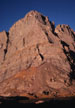
Crestone Needle, Ellingwood Ledges Direct
By: Gary Clark | Climbers: Gary Clark, Mark Schraad |Trip Dates: August 11, 2002
Photo: Gary Clark
® The author(s) and naclassics.com | ![]() Back to climb page
Back to climb page ![]() NAC Home page
NAC Home page
|
|
Crestone Needle, Ellingwood Ledges Direct By: Gary Clark | Climbers: Gary Clark, Mark Schraad |Trip Dates: August 11, 2002 |
|
Photo: Gary Clark |
® The author(s) and naclassics.com | |
|
If you are a regular reader of North American Classics, you might be wondering two things: First, why is this guy climbing this route again, only three weeks after posting a July trip report? And second, why is he writing about it again? Good questions, both. The answer to the first is that Lynn didn't get to come out and play on the July trip, and she gets cranky when I'm having a good time without her. Second, I have a few more things to say about the route. This might be my last report on this route, but probably won't be the last time I climb it. The July trip with Mark Schraad had dual purposes. I wanted to see if we could do the route comfortably without backpacking to a camp, and I wanted to try the direct start. Both of these experiments had been successful. We gave up on driving the entire 4 wheel-drive road, but still managed to make a round trip to the summit and back from a couple miles short of the parking lot, with plenty of time to drive home to New Mexico before dark. On this more recent trip, besides sharing the experience with my wife, I wanted to see if we could improve our tactics and our time on the route. Mark and I had done it in 2:20, but we weren't really trying, and only figured out our time afterwards from recalling glances we had made at our watches. I think I finally have the tactics for this route figured out. First, it just isn't necessary to beat a nice SUV to death on the approach road. In July, we drove 1.5 hours and hiked an hour to get about 6 miles. The top section of the road is the worst, and I figure it would have taken about 45 minutes to drive it had we continued. On this trip, we hiked the entire road from the parking lot out in the valley in 3:15. So, you might gain about an hour by driving. As we hiked the road, we followed a line of oil blobs that likely represented the slow bleeding death of someone's vehicle. We had driven over 5 hours from New Mexico that morning, and still were able to reach a campsite below the South Colony Lakes by early evening. The hike was little more than a good warm-up for the legs. On Sunday morning we woke at 5:00am. We were in no hurry to arrive at the base of the route, but once on the trail our pace quickened as we saw headlamps materializing all over the South Colony Lakes Valley, and amazingly, well up the ledges of the regular route. We were hoping not to have to pass a lot of parties on the route, so we quickened our pace a little, arriving at the base of the route around 6:00a. Again, this was little more than a good warm-up, so it doesn't seem necessary to seek a higher camp than ours below the lowest lake. Lynn had naturally been concerned about climbing the direct start unroped, but once on the rock quickly settled into a steady rhythm, and I could tell that I would not be waiting for her. The memory of the route was still fresh in my mind from 3 weeks ago, so we had no false starts. Things were going well. Now, what to do about the party of three up at the Red Tower? They were simul-climbing, roped together with two full-length ropes. Although that would be much faster than belaying, it couldn't compare with unroped soloing, so as I approached I asked the lowest climber if we could pass. He didn't mind, and soon they were behind us. I thought we were now highest on the route, but to my surprise, a helmet appeared well above. Groan . . . it looked like we would converge at the base of the headwall, which would destroy any hope we had for a fast ascent. However, as I appoached the headwall, I could see that they were in a crack off to the right of the normal line! I could have yelled "Hey, do you know you're off route?" but I've learned not to do that - people often have a good reason for being "off route." Maybe they just wanted to try that crack. In this case, it turned out they were, in fact, off route. We stopped to get the rope out and began simul-climbing the first headwall crack with running protection. As we passed them we heard their leader call down:"This is getting pretty sketchy up here, I'm running out of options!" His partner responded, with a note of disgust: "The party passing us over the left doesn't seem to be having any trouble!" If they had only bought the North American Classics CD, they'd have had the definitive route description! We had an 80ft. x 8mm rope, which we doubled for simulclimbing. Many parties make the mistake of simul-climbing a full rope-length apart. You need to be in close voice communication so that allowances can be made when one climber arrives at a tough spot. Our rack consisted of 3 quick draws, 3 regular length slings, and two small chocks. This was about right, although I'd recommend active cams instead of chocks, being quicker to place and remove and more versatile. At the base of the crux final pitch, I stopped to collect the slings with which I had been clipping the numerous fixed pins. Although the crux crack is about the same as the lower crack for most of its length, there is one move that demands respect. The dihedral turns steep for about 8 feet, while positive face holds largely disappear. The last time I did this I probably got as much friction from my belly as my shoes. I was determined this time to improve on that sad performance. Calling down to Lynn to minimize slack in the rope, I tried stemming widely to the left instead of just dragging my bulk over the bulge on one poor hand jam. The only foothold I could find was so far away that, once committed to a stem from it, I found it quite difficult to move back to the crack. Again I made an awkward move in an exposed position, one I might have called 5.8 had it been combined with a few more like it. Fortunately there was a fixed wire at my waist and a piton about 5 feet lower. Lynn is about 10 inches shorter, so the wide stem was not an option. When she arrived at the crux she called up so I could set protection, then turned her right hip to the wall and moved up on a friction smear on vertical rock. I'll say it again - for 5.7, this is a non-trivial move! Above here the crack goes back to its former moderate nature, and we moved up easily, relieved that the crux was over and the summit only a few hundred feet above. Our watches were in our packs, so neither of us had checked the time yet, but I had a feeling we were doing pretty well. We unroped and began a sprint for the summit up a 3rd-class gully. The 'sprint' lasted about 20ft before I was blowing like a whale and forced to slow down or risk passing out. Now close to 14,000ft, we had to carefully pace our scrambling to avoid going totally anaerobic. We arrived on the summit to a brisk, chilly breeze. I fished in my pack for the stopwatch, but Lynn found hers first. At first we weren't sure we could believe the reading, but I confirmed it on my watch: One hour and 19 minutes from the base! As a rule, I'm not interested in rushing up mountains, other than to ensure safety by not being caught in a thunderstorm or unplanned bivouac. However, I must admit that this experience was quite satisfying. The first time I did this route in Vibram-soled mountain boots over two decades ago, it was a full day's adventure, and we were content just to reach camp at the lake below by dark. Now 5 ascents later, I have the tactics refined to the point that we were able to complete the descent via the regular route back to our tent, hike the road out to the valley, and drive 290 tortuous miles home before dinner. Postscript 1: My intention here is certainly not to impress anyone with our time. First, I am not interested in initiating a contest on this route. Second, any competent fit climber could easily eclipse this time. About to commence my 57th year on the planet, I am at least 10lb overweight, and the pressure of work has kept me from devoting more than token amounts of time to fitness activities this year. In short, I'm a fat, out-of-shape old man. So why am I writing this? Well, first to make the point that I see little reason for literally hundreds of 4WD vehicles continuing to degrade a beautiful wilderness area just to save an hour of time. There is little justification for the continued existence of this road, originally built for access to a mine. At one point while hiking out, we had to literally jump aside as a group of motocross riders raced down the road, spending more time in the air than on the surface. Aren't there more appropriate locales for this type of activity? There were about 30 vehicles in the parking lot and another 60 in the canyon on this particular weekend. The human impact from this many visitors inevitably compromises the wilderness values they are ostensibly seeking; why should it be made any easier? Postscript 2: There is one additional tactic I have not mentioned. Every time I hike into a popular mountain area I see people carrying bone-crushing packs, often simply for an overnight stay at a lake. If you pack 40 to 60 pounds up that road and 20 up the mountain, I seriously doubt you will be able to do the round trip in the times I list here, even if much younger and fitter. Traveling light is key to traveling fast. Our packs were under 20lb for the backpack and under 10lb for the climb, including food, water, and descent shoes. To show that we weren't going light by being irresponsible, I include a complete list below. Gear list for one person. The items with an asterisk (*) were not used on this perfect weather weekend, but I carry them just in case.
|