Mt. Assiniboine, North Ridge
By: Gary Clark | Climbers: Gary & Lynn Clark |Trip Dates: August 2-5, 2001
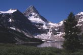
Photo: George Bell, Jr.
® The author(s) and naclassics.com | ![]() Back to climb page
Back to climb page ![]() NAC Home page
NAC Home page
|
|
Mt. Assiniboine, North Ridge By: Gary Clark | Climbers: Gary & Lynn Clark |Trip Dates: August 2-5, 2001 |
|
Photo: George Bell, Jr. |
® The author(s) and naclassics.com | |
|
Late December, 1973: Mick Holt, Dave Neff, and I stand on the summit of Mt. Victoria gazing at the incredible spectacle of the Canadian Rockies in winter. The temperature is somewhere around -32C (-25F), and the day sparkles, with visibility that reaches beyond the horizon. We have just climbed the NE Face, a routine outing during the summer, but a big adventure for three college students on Christmas Break. With typical youthful exuberance, we spend only a few minutes enjoying this success before picking out objectives for the future. Way off to the south is a pointy summit that towers above its neighbors. "That's Assiniboine," Mick offers, and soon we are doing high 5's while chanting "Assiniboooooooine" as a way of sealing our commitment for the future.
The years go by, we all drift off to separate parts of the planet, and our pact is largely forgotten. Until, at least, the early 90s, when my wife Lynn and I began our nearly biannual trips to the Canadian Rockies in quest of the "Fifty Classic Climbs of North America." We soon learned that this is rather elusive prey. Rather than just tick them off almost at will as we had been able to do in the "Lower 48," we learned a variant of the three rules of real estate (location, location, location). In this case, it's condition, condition, condition. We came early. We came late. We flew. We drove. Gradually we began to learn how to deal with the highly variable weather and its effects on the routes we wanted to do. At first, my attention was riveted only on the "Fifty Classic" routes, but this was a mistake - during a given season many of these might be totally out of condition, but there were superb climbs everywhere we should have been attempting. Assiniboine was one of these, but it didn't make it to the top of the priority list until our trip in 2001.
Wednesday 8/01/01: We are in Canmore after the long drive from New Mexico. It's good to be back in real mountains. We gaze at the 360 degree spectacle of limestone peaks forming the walls of the Bow River Valley in awe and appreciation as we do domestic chores and research the conditions for Assiniboine. First a trip to the helicopter service, located a few km east of town. Rather than burn a full day of vacation and energy on what was reputed to be a long but rather unrewarding approach hike, we wanted to explore taking the regularly scheduled helicopter to Lake Magog, situated at the base of Mt. Assiniboine. The view of the lake and the peak is the one usually seen on calendars and postcards; it was such a photo that got me recommitted to the climb. There is a lodge here, a warden station, campgrounds, and some cabins, some of the latter two being available on a first-come-first-served basis. It came as a surprise that we couldn't book a helicopter flight at the heliport. Even though this was the company headquarters, the bookings were done by people at the Lodge at Lake Magog. They were reachable by phone, and after several time-wasting attempts, we learned that we'd either have to waste a couple days of perfect weather, or hike. We decided to hike. We also called Parks BC to inquire about conditions, and a very cheerful and helpful woman offered "Oh, climbing conditions are perfect on Assiniboine - there hasn't been a storm in 10 days, so it's quite dry" I almost couldn't believe my ears, but our "hope-meter" pegged out and we hustled back to our campground to begin packing for the morning. Thursday 8/02/01: Driving south out of Canmore to the Mt. Shark trailhead, we arrive about 8:00am. We were looking at about a 20km hike to the lake, and decided that our unaccustomed feet would only survive this if we took 10min. of every hour as a break to take the boots off, re-hydrate ourselves and have a snack. This turned out to be an excellent strategy. The trail is largely flat for the first 15km, but then it turns south and begins climbing in earnest toward Assiniboine Pass. There were very few people on the early part of trail, but as we approached the pass we ran into several large groups, all of which were just out for day hikes. One returning group said "Don't turn back too soon - it's really worth it to go all the way to the meadows", not realizing that we were here for the "whole enchilada." We travel light, and people sometimes assume from the size of our packs that we are day hiking, when we in fact have a multi-day alpine climb planned. We began to top out at the pass, and for the first time all day, we caught a glimpse of the mountain through the trees. I couldn't believe my eyes. It was totally plastered in snow. The "hope meter" took a nose dive as I realized that the woman at Parks BC, while trying to be helpful, had no clue what the conditions were. (This is, in our experience, unusual - the advice we've gotten from the Park services has usually been spot-on. It is important to talk to a climbing warden, though, rather than a general information desk person). As we approached the lake, we saw a sign for the Warden cabin. Deciding we might get better advice on conditions there, we began a detour that turned out to be several kilometers. However, it was worth it. As we chatted with Allen, the friendly and knowledgeable warden, he not only indicated that, although the mountain looked bad, several parties had been up it in the previous days using crampons. Hope renewed, we went down to the Lodge to register for the RC Hind hut, and headed for the "Gmoser Highway." This is one of two ways to approach the hut, which sits high on a shale layer to the north of the mountain close to the base of the route. It is possible to reserve a spot in the hut by phone, by calling the Assiniboine Lodge. They seem to do all reservations: The Lodge itself, the helicopter, and the hut, although the latter actually belongs to the Alpine Club of Canada. The hut holds 16, but only 8 spots are reservable; the rest are first-come, first-served. The "Gmoser Highway" was discovered by pioneer Canadian Climber Hans Gmoser, with the intent of avoiding the steep couloir that had been used for years to access the peak, but which had been the scene of a lot of accidents. In good years and cold conditions, the couloir might still be preferred. However, almost everyone now uses the Highway, since a decent trail exists for most of it, and the tricky sections are well marked with cairns. We found it non-trivial in places from a route-finding perspective, but after one off-route excursion had me crawling on my belly on a horribly exposed ledge narrower than my body, we committed to not going anywhere without positive sign that we were on route. As a general bit of advice, when in doubt, look up. A cairn might be above your head, and a few easy moves on steep rock will put you back on track. Warden Allen had predicted a three-hour trip to the hut, and that was right on. We arrived expecting to see others, but surprisingly had the entire place to ourselves. However, we were bone tired. The long hike, the detour to the Warden's cabin, then the grueling and relatively difficult "highway" had eaten all the physical reserves we brought to the task. We both wondered as we prepared dinner whether we'd be in the mood to climb in the morning. Friday 8/03/01: We woke to the alarm at 5:00a; not the true "Alpine start" called for by the objective, but as ambitious as I was willing to commit to the night before. I lay in bed a few minutes wishing I didn't have to make this decision. It would have been very easy to go back to sleep, but finally some force got me out of bed to go up and 'take a look.' We left the hut at 6:30, an hour later than originally planned. The first scree slope to gain the crest of the ridge was a bit like going up the down escalator; it is so loose that no real good trail can remain for long. Once on the crest, we could see the weakness in the lowest rock band that, once overcome, would put us really on the route, rather than the approach. We started to notice the plentiful cairns which would help greatly in staying on route. The most helpful thing, though, was the tracks from the party that climbed it a few days before. We had learned at the lodge that this was a guided party, so we assumed (correctly, it turned out) that the leader was familiar with the route. Whenever in doubt, I would just look hard for a boot print in the snow before committing to my own route finding. Above the first band we remained well to the left of the ridge crest where the rock seemed to be monolithic and solid. This resulted in a lot of 4th-class climbing, but generally I prefer making more difficult moves on solid rock than climbing lower grade slopes covered in rubble. The guided group had climbed a long tongue of snow at one point, so we put on our crampons and followed the tracks. It would turn out that we didn't take the crampons off the rest of the day until back to this point. Eventually we drifted over to the ridge crest. The climbing got immediately better. Most notable, though, was the gut-wrenching view onto the East Face, a formidable piece of real estate if I've ever seen one. I was reminded of another ridge far away and long ago. The NW Ridge route on the Eiger in Switzerland often brings you right to the cliff edge of the North Face. The exposure and condition of the face has a visceral effect, and I usually feel better while climbing on such an edge to just try to block it out of my peripheral vision. Anchors began to appear, most of which looked to have been placed for rappelling. By clipping these and placing infrequent protection from my light rack, we moved fairly efficiently along the ridge, simul-climbing on a doubled 60m x 8mm rope. 30m. is a reasonable separation distance, but 60m. all but eliminates communication, so doubling the rope works pretty well for us. The first big obstacle was just above: the Red Band. From below we could easily see the line of weakness, which is the narrowest part of the band, and the ramp that leads up to it from the ridgeline. I reached the band easily, but was a little surprised at the conditions. A thin ribbon of ice in the back of the dihedral seemed to be the best option. I had been expecting moderate rock climbing. There are, perhaps, other options here, but we were clearly right on the line shown in the guidebook. I could see there was to be no protection on this step other than a very poor wire I placed near the bottom. Front pointing up it, I planted a pick over a small bulge in the ice and pulled up to see a huge rappel anchor to the left. This didn't imply I was on-route, of course; it could have been just another place to rappel. Now we had a ramp to the left on snow, which we had been dreading because of the exposure created by the Red Band just below, and the knowledge that it was usually rubble covered and unprotectable. I was relieved to see a solid snow layer, still crisp to the crampon's bite. Reaching the ridge again, we enjoyed some of the best climbing on the route. From the top of the Red Band to the summit is pure quality alpine scrambling, with the occasional challenging bit thrown in to keep it from seeming completely routine. There were anchors everywhere. To someone on the route in perfect, dry conditions in good weather, the number of anchors might seem unjustifiable. Perfect, dry conditions in good weather are rare. On the way back down, we used all these anchors as melting, rotten snow, wet rock, and rubble-covered ledges combined with serious exposure to convince us that a slow, safe descent was preferable to a quick involuntary one. We knew we had arrived at the Grey Band when we bumped up against an alcove under an overhang. There was a substantial fixed anchor there as well. We took off our packs for the first time, had some food and drink, and then I went around the corner to explore. At first, it looked improbable that this band of rock could reveal a moderate passage. I quickly discovered a gully that was hidden from view until you are at its base. Fixed pitons alleviated the need to place my own gear on the steep, well-featured face to the left of the dihedral. The holds were big enough that it didn't even occur to me to remove my crampons. This was unquestionably the best climbing on the route, but sadly it was quite short. I had expected to be on a snow ridge leading directly to the summit above this band, but that is not the case. There were at least two more obstacles in the form of short 5th-class bands to negotiate before the angle began to back off, and then the summit was in view. At least we thought it was the summit. The steep scenic corniced point off to our left turned out to just be a crest on the ridge; the true summit was still several rope lengths to the south. In deference to the cornice, we stayed well back from the edge as we reached the top, looked around, said, "Wow, awesome view," then immediately "Let's get the Hell off this thing." I should spend more time on summits, I guess, but I long ago realized that it's the journey that I'm after, and am always just anxious to get on with it. Still, a stay of 15 seconds on such a significant summit is probably a bit minimalist. It was around noon. This was clearly not going to go down in the annals of the sport as a standards-setting speed ascent. We didn't care. The descent would be even worse in the speed department, a typical scenario for this mountain. What had seemed justifiable for unroped or unanchored scrambling while facing the rock now was not so trivial on the descent. We did a lot of rappels, placed a lot of protection, and generally took our time to ensure we constantly had at least one anchor between us until below the Red Band. The weather was never threatening, so time was not an issue, and we had already planned on spending that night at the hut rather than attempting to hike out. From well above we could see parties setting up tents around the hut. They may have just brought tents in case the hut was full, preferred tenting to the inside of the hut, or didn't want to spend the $15 apiece. At any rate, I thought it was a poor option. We were comfy in the hut that night as it rained and the wind whipped over the exposed plateau on which it sits. I can't imagine anyone outside got much sleep in their flapping tent or bivouac sack. Two Canadians were inside, so we shared climbing stories until they were ready to go to bed in anticipation of an early start the next morning. We were still supercharged from the day, so they probably just wished we'd shut up and go to sleep. Saturday 8/04/01: We slept in late, then made some breakfast. The weather was now quite poor, with constant wind, frequent showers, and a cloud cap extending well down the mountain. We felt sorry for the climbers up there, and very glad I had decided to drag my lazy butt out of bed for a go at it the day before. We were ready to leave when it began raining hard again, so we pulled out a board game called 'Peak Experience', based on climbing K2. I was barely ahead in the game, having just reached camp 2, when Lynn spun the wheel, then took a card which simply said "You are killed." It wasn't specific whether this was due to an avalanche, a fall, or execution by Islamic fundamentalists, but the game was over just the same, and most importantly, I had won. At regular stretches throughout the morning we gazed out the window hoping to catch sight of someone on the route, but the cloud cap never dissipated. Around 1:00p the weather cleared long enough for the rocks to dry, so we started down. A snow slope north of the hut provided a nice long glissade, saving considerable boulder hopping. We made the ranger station in about 3hrs, stopping only to chat about the climb with a group on their way up. We checked out with the ranger, and went to 'overflow camping,' which was wherever we wanted to plunk our tent in a virgin meadow next to the cabins. There were about 15 tents there already because of the huge holiday weekend, and more would arrive before nightfall. It was actually lucky for us that the regular campground was full, because otherwise we'd have had to hike back there, a round trip of about 6 km. It rained frequently throughout the night. Sunday 8/05/01: We were up before any of our neighbors, and left camp within 15 minutes, forgoing breakfast until later. The first goal was Wonder Pass, as recommended by our hut-mates who were hopefully by now safely off the mountain. This hike was ethereal as the sun rose and colored the walls above several small jewel-like tarn lakes. Soon the trail turned to the east and steepened into a series of switchbacks. We crossed the pass, waved goodbye to Assiniboine and the Lake Magog basin, vowing to come back some day. The plan was to have breakfast at the first stream crossing. However, we finally gave up and sat down at a scenic spot on the trail after realizing there would be no running water on this side of the pass. Although there is melting snow, it goes underground in talus fields. Taking our boots off, we spread our breakfast out on a pad and proceeded to enjoy the morning sun. A motion to our right caught my eye, and I was quickly on my feet, as was Lynn. "OK," she said. "We've talked about this situation before, let's just back up slowly and keep talking to it, and don't look threatening." The grizzly had now stepped onto the trail, headed our direction. He was, I determined later, about 6m (20ft) away. I was backing up when I glanced down to see my axe on the back of my pack. There was no question in my mind he would come for our food conveniently spread out like a smorgasbord, but it was what he might do next concerned me. If either of us were going to be attacked, I wanted to go down swinging. As I crouched down to get my axe off the pack, he simply turned and ambled off down the slope. I remembered a little too late to grab my camera to record the moment, and got a few frames with a small brown dot in them. We quickly packed up and headed down the trail, exchanging excited chatter for the next several miles "I can't believe he didn't come for the food!" . . . "Oh, man, that was awesome," etc. We couldn't have guessed that there were more interesting animal encounters in store. The trail down from Wonder Pass is, indeed, a wonder for scenery, but perhaps only to those descending it. It loses about 900m of elevation, and would not have been so delightful had we been carrying heavy packs up it, like several parties we encountered. About 30 minutes after the bear encounter I noticed a Willow Ptarmigan on the trail. I motioned for Lynn to stop, and we stood still while it edged closer. I suggested she imitate its call, which she is good at, and as she repeated it, it came closer. Finally it was right at my feet, and Lynn began taking pictures. I couldn't believe how tame it was, but especially surprised when it starting attacking me! The image of me trying to shake a ptarmigan off my pant leg was truly comical, and we kept laughing after I finally disengaged it and we hustled down the trail with it in full pursuit. This continued for the next quarter mile, with us both cracking up at the ludicrousness of the scene. As we met parties coming up, we warned them first to keep an eye out for the Grizzly, and then for the "Killer Ptarmigan." The rest of the hike was considerably more routine. We arrived back at the Mt. Shark parking lot late in the afternoon, tired and ready for the accoutrements of civilization, but secure in the knowledge that we had just experienced one of the finest mountain trips of our lives. |