Grand Canyon Trek 2009
Huitzil Point Route into Royal Arch Loop
November 7-14, 2009
Author and Trip Leader: Rick Light - Bio.
Participants:
Al Bouchier, Karl Buckendahl, Glenn Burow, Norbert Ensslin, Don
Krier, Rick Light, Roy Michelotti, Tobin Oruch, Greg Scudder.
Full Photo Gallery:
click
here.
Overview:
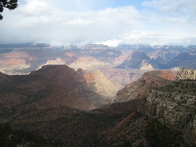
The Royal Arch Loop is a well known route in the western Grand
Canyon that explores the one large natural arch inside the park.
This loop begins at the South Bass Trailhead, heads west to the
Royal Arch Creek drainage, then northeast to the Colorado River at
the beach where the drainage below Toltec Point meets the River,
continues east along the Tonto trail to the South Bass Trail, and
back to where it began. This loop includes some 42 miles of hiking
on back-country trails or negotiating boulders in the Royal Arch
Creek drainage. Our trek was a variation of this loop trip,
following a rarely taken descent route noted by Harvey Butchart that
descends below Huitzil Point. This route of descent was apparently
used extensively by indigenous peoples of the Canyon, as there are
significant signs of their involvement in its establishment and
use. By taking the Huitzil descent route we cut the mileage of the
trip to about 33 and gained a lay-over day.
Overall Trip Plan:
-
Sat Nov 7th:
Drive to Tusayan, overnight in hotel
-
Sun Nov 8th:
Drive to Pasture Wash Ranger Station, descend to arch, camp
there
-
Mon Nov 9th:
Hike via rappel to Toltec beach, camp there
-
Tues Nov
10th: Layover day - explore area, day-hike to Elves
Chasm
-
Wed Nov 11th:
Hike east to dry camp along the Tonto
-
Thurs Nov
12th: Continue hike east to South Bass Rapids, camp
there
-
Fri Nov 13th:
Hike out, drive to Flagstaff, celebratory dinner, overnight in
hotel
-
Sat Nov 14th:
Drive home
What
Actually Happened:
Our
plan was to work only if (1) the weather allowed us to descend dry
rock, and (2) if we could find the drop-off point near Huitzil
Point. The fall-back contingency plan of course was to simply do
the regular Royal Arch Loop with no lay-over day. Luckily the
weather was great, so we left the hotel early to began hiking at
8:30am from Pasture Wash Ranger Station. Finding the descent was
non-trivial, but we were assisted by the fact that Karl had done
this descent some years ago, and by the fact that we had a GPS
coordinate for what we thought should be the appropriate place.
The
Huitzil descent route includes a couple of small cliffs down which
we had to lower packs and then down-climb, a wonderful cave-like
passage that includes an old tree (probably several hundred years
old) that is used as a ladder inside the passage, some steep Moki
steps (worn cup-like footholds in the rock from the repeated use by
Indians), and a steep scree slope. We passed packs through the cave
but worn our packs down the Moki steps to save time. A 90-foot 9mm
rope was used as our belay line descending the steps. As it turned
out, only the first step is really dangerous, the rest are pretty
safe to do, but the exposure and carrying a full pack made it seem
more dangerous than it probably is. We had no falls nor injury
during this descent, arriving at the bottom of the Moki steps around
mid-day with another hour or so to reach the side drainage leading
into Royal Arch Creek.
We
then began the descent of Royal Arch Creek itself, choosing the
entry drainage nearest to where we came out rather than the one
normally taken when hiking from South Bass. This creek bed is
really cool, interesting, and fun to negotiate. It turned out to be
more "interesting" than we anticipated, ending our long first day
from Pasture Wash not at the Arch but a mile or so from it
upstream. We camped about half-a-mile short of the Toltec beach
trail turn-off (and the arch a quarter mile or so below it),
arriving at camp just before sunset. Then our 2nd day of
hiking included working our way down to the turn-off, dropping packs
there, day-hiking to the arch and back, picking up the packs to then
hike the steep trail (including the 20' rappel) down to Toltec
beach. The rappel turned out to be a small cliff, 15-20 feet or so,
that we in fact rappelled rather than down-climbing. With nine
people it took a bit of time to get everyone and their packs down
safely, but it went very smoothly. Once at the River, since we had
successfully completed the Huitzil descent route, we now had 2
nights to camp here with a lay-over day to explore Elves Chasm or
just chill in camp.
Those of us who chose to go to Elves Chasm found the trail rough
going � basically the same as we had been encountering all along so
far � so it took us about 1.5 hours each way to hike the mile and a
half. The Chasm itself is a pretty oasis with gorgeous pools for
swimming � if you have the nerve � it's pretty cold water and a deep
enough canyon that there's not much sun most of the day this time of
year. Fun to explore and relax for a day.
For
the 4th day we faced a choice � to dry camp half way
between Toltec beach and Bass Rapids, or try to go further and have
a short day of hiking after the dry camp. We chose the 2nd
approach, hiking some 10 miles to the head of Copper Canyon for our
dry-camp. Then we had only 4 miles to hike the following day to
reach the South Bass Trail, where we set up camp near where a spring
should be (but we never found), and then day-hiked to the River to
bathe and get water for our dry-camp and for the hike out the last
day. It worked very well.
Our
ascent on the 6th day turned out to be overcast, windy,
occasionally raining or snowing, but mostly just wonderfully cool.
The South Bass Trail is a well used and maintained trail, recently
cleaned-up by the looks of it, a venerable highway compared to what
we encountered earlier in our trip. It is 6 miles and 4000 vertical
feet from our campsite at the spring to the South Bass Trailhead.
Everyone arrived safe and healthy and ready for ice cream, a shower,
and dinner at the Beaver Street Brewery in Flag! Nobody lost,
nobody dead � must be another successful trip!
A
Couple of Notes for Future Reference:
We
took two 90-foot ropes, one 8mm and one 9mm. Probably could have
done with only one long one and one much shorter one. We also took
2 tubular nylon swami-style sling harnesses and one Alpine Bod
harness. Would have been a bit heavier, but much simpler and faster
at the rappel to have had a couple of Alpine Bod harnesses instead
of the sling ones.
Most
of our packs weighed 40-45 pounds as we started off. This included
at least 4 to 6 liters of water for each person in case we had to
dry-camp the first night. This turned out to be well worth doing,
even though it was heavier than we might have liked.
We
used 3 canister stoves for this trip with 9 people. Ended up using
4.5 220g canisters for the 90 person-meals required.
Hiking and Driving Times:
The
first day we left the hotel at 6:30am, drove the hour and 10 minutes
to the ranger station, shuttled cars to leave one at the South Bass
Trailhead, and then began hiking at 8:30am from Pasture Wash Ranger
Station to reach the tip-off around 9:30am. We reached the bottom
of the Moki steps at 12:30pm, and the bottom of the drainage by
1:30pm. Finally reached a place for a dry camp at 5:00pm.
We
started the 2nd day at 8:30am, dropped packs at 9:30am,
were back from the arch by 10:30am, finished the rappel by 2:45pm,
and arrived at the Toltec beach camp by 3:30pm.
The
hike on the Tonto took 6.5 hours to hike between Toltec and Copper
camps, reaching the western end of the Tonto after only an hour
(from Toltec to Garnet Canyon). The next day took only 3.5 hours to
hike to South Bass Trail (where the spring is noted on the map, but
we didn't find), and only 45 minutes each way to the River.
On
the last day, the fastest of our group reached the Rim in 3 hours 45
minutes. Most of us got there in 4 hours and 15 minutes, and a
couple arrived after 5 hours of hiking.
It took 1.5 hours to drive from the South Bass Trailhead back to the
GC Village.
