Author
and Trip Leader:
Bill Priedhorsky - Bio
Participants:
Allyn Pratt, Nellie Schachowskoj, Jan Studebaker, Kathleen
Gruetzmacher, Joy Green, Ray Green, Jackie Little, Peter McLachlan,
Rachel Hixson, Pat McLachlan of Olympia, Washington, Dick Opsahl,
and Bill Priedhorsky
Photo Gallery: by
Jan Studebaker
This is the story of a five-night canyon adventure in
the wild slick rock of lower Sand Creek over the long Columbus Day
weekend of 2009. Because of the 10-hour+ drive, we usually go for a
whole week when we travel to the Escalante country. To save vacation
time, the 2009 trip was designed to fit a long weekend plus two
vacation days. We thus needed a campsite close enough to the
trailhead that we could break camp, hike out, load up, and drive
back to Los Alamos in one day. Our campsite, at the confluence of
Sand Creek and the Escalante, was just 2 1/2 miles from the
trailhead along highway 12.
To our surprise we
found ourselves in the wildest and most rugged slickrock country
that we had seen in the Escalante. We had passed through this
country a few times, for example on the return to civilization of
our Willow Patch trip of fall 2004, but have not spent significant
time there for many years. My son Reid passed through in spring 2005
(read here);
our trip was entirely more pleasant than his passage through record
spring floods.
Being somewhat
lazy when it comes to carrying of heavy loads, our trip was a llama
drop camp: llamas carried our gear into a base camp, and came back
to haul out our gear when we are done. This typically gave us about
70 pounds of cargo per person, making possible the comforts of
chairs, tables, Coleman stoves, and a wine cellar. We engaged the
services of
Red Rock 'n Llamas for the hauling, Because we had only 11
llamas for our party, some of us carried modest loads on our backs,
but nothing like a full backpack.
Most of the
expedition left Los Alamos mid-afternoon on Wednesday, October 7,
and drove the 6 hours to Bluff, Utah to overnight at the
Recapture
Lodge. We arrived early enough to soak and sip wine in the
Lodge’s hot tub, a place with some history for us, where we have
spent many an hour.
We left Bluff at
about 7:15 AM on Thursday and drove overland (the timing was not
right for the ferry) to Boulder, Utah, arriving at the trailhead a
little after noon. Loading llamas took a couple of hours, but with
the short hike, we arrived in camp with plenty of time for drinks
and dinner. Our campsite, near the confluence, had room for all of
our tents and dinner circle. A special treat was a dripping spring
along the cliff wall. With spring water to drink, we never took our
water filters out of their bags. The October sun did not hit camp
until about 9:30 daylight time, so mornings were cool.
On Friday morning,
we were ready for the main event: day hikes and scrambles in the
slickrock expanses, domes, and clefts. We managed to start our hikes
by 9:00 or 9:30 AM each morning, knowing that the days would not be
long. There was usable light until about 7:00 PM, but we wanted to
return to camp in time for drinks, appetizers, and dinner before
dark. For our first outing, we explored the country north of the
Escalante River and west of Sand Creek. After one false start where
an apparent route was blocked by an 8-foot ledge, we returned to the
creek and found some remarkable petroglyphs, including a Kokopelli,
on a varnished rock that had fallen to the canyon bottom. We then
found a scrambly route out of the canyon, and hiked across the
plateau to a slickrock expanse under a line of cliffs and
prominences. We found no way directly to the top, although Kathleen
and others explored several possibilities. Our way westward under
the cliffs was blocked by a narrow chasm over a hundred feet deep.
We dropped down to the southwest and found two routes to the river
bottom, then followed the river back to camp.
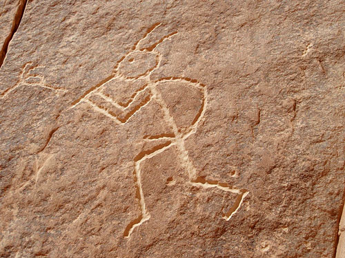
Rock art in lower Sand
Creek.
On the second day we explored the
Bowington Road to the south of the Escalante River. The diagonal
slash of the old cowboy road had been visible from the north side of
the river the day before, and we were able to pick up the road after
some exploring. The converse was not true – we never found the
continuation of the road on the north side of the river. In search
of the road, we started up the first drainage upstream from Sand
Creek on the south side of the Escalante, and had to cross a rib to
the second drainage to find the actual route. Once on track, we were
able to follow the road for about a half mile before it faded into a
huge expanse of slickrock. The party split at this point, with Dick
Opsahl, Jan W., Pat M., and Kathleen following due south upslope,
while the rest of us headed for a sandstone peak to the west. Most
of our travel was on bare rock. As we approached, we saw that the
peak was actually a knob at the end of a peninsula coming out of the
cliff wall. We reached the base of the peninsula via a drainage to
its south, and followed along its top to the end. The summit
required a little rope work. Although it was not a free-standing
peak, there was plenty of exposure and view, with a nearly
vertically drop several hundred feet to the river at our feet. On
the way back, Jan S. and I explored a bowl directly south from the
peak, and found an easy shortcut to the bottom. This route looked
impossibly steep on our hike in, but the angle of slickrock can be
deceptive when seen straight on from a distance.
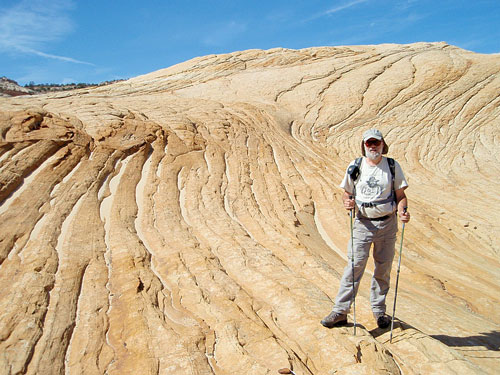
Fearless leader Bill
in his favorite place, the slickrock,
west of the Bowington historical road.
Retracing our
route to the Bowington Road, we stopped at a large pool filling a
declivity in the slickrock. Our party arrived just as Dick and the
ladies were drying off from a swim, and we jumped in ourselves for a
dip and wash. On the way out, Jan S. and I missed the path to the
road and took a big loop around a high point, looking in vain for an
alternate way down. We finally returned, full circle, to the
beginning of our loop and found the road, and then came across
Jackie and Ron making their way down the one alternate slope that we
had missed.
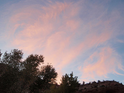
Sunset from our
beautiful camp near the mouth of Sand Creek.
On Sunday, our
third day, I hoped to do a little fishing, so joined the hikers for
an exploration of the country north of the Escalante and east of
Sand Creek. We found an easy route up from Sand Creek bottom on the
east slope near camp. My plan was to stay with the hikers for a
while, then find a way down into Sand Creek to check out the trout.
Although I sped ahead of the main party and spent two or three hours
looking for a way down, I found no descent possibilities downstream
of Sand Hollow. Although there were possible ways to drop into Sand
Hollow, I remembered, from a previous trip, that there was no way
down from Sand Hollow into Sand Creek due to a drop-off near their
confluence. I gave up and started back, and soon ran into the main
party. We hiked back together, arriving at camp about 3 PM. I took a
short excursion upstream with rod in hand – although I was
disappointed to find that my reel had broken. Duct tape reconnected
it to the rod, but this was hardly a high-performance angling
system. I caught and released about three 10-inchers, and chased off
a few dozen more when I took a dip in the stream just a hundred
yards from camp.
An advantage and
disadvantage of our location was the temptation of a quick jaunt
back to civilization. Also on Sunday Al and Nellie, and separately
Peter and Rachel, hiked out and drove back to town. While Allyn’s
gift – a couple six-packs – was eagerly received, it worrisome to
wait after dark for one of the returning parties. We were in the
wilderness, not civilization, and were tied to each other with bonds
of responsibility different from when we make our independent ways
through the civilized world.
Monday proved how
steeply the slickrock lies in this corner of the Escalante.
Kathleen, Jackie, Ron, Jan S., Jan W., and myself set out again into
the northwest quadrant, west of Sand Creek and north of the
Escalante. We found a more directly route across the beaver dam,
around a corner, and up out of the canyon, then set a goal –a
sculptured plateau at the top of the cliff line. For the usual
slickrock summit, with a little will, there will be a way, though
with a challenge or two en route. This peak was different. We worked
our way across the grain and rounded the east corner of the
slickrock mass, figuring that we could find a friction route up the
skyline. Exploration showed that we were about twenty feet short,
blocked by a sandstone slope that was just beyond our capability.
Continuing along the east slope, we found a gully with some promise.
We explored multiple options, and eventually reached a plateau just
below the summit. Our way up involved a hairy bit of rope work.
Setting up for the next climber, the rope lassoed a hundred pound
rock uphill from Jan S. Pulling on the rope would have brought the
rock down onto Jan, and the only way out was Jan’s climb up a
friable slope to free the rope by hand. Bill found a chimney that
led to a staircase along the rock face, with only modest trashing
through the bushes that blocked the gully. Although we did not reach
our original goal, we enjoyed huge views up to Boulder Mountain,
then found a straightforward descent a little north of the gully
route.
When we begin a
multi-day trip, it always seems like we have all the time in the
world. But quickly enough, the last day is open us, then the last
evening in camp. About dinnertime packers Locke Wade and Brian Dick
hiked in with the llamas to make possible an early start on
the morning of Tuesday, October 13. We woke in the dark about 6 AM,
packed quickly, and were on the trail by about 8:30 AM. The hike out
went quickly, reaching the cars about 10:30 AM. With loading the
cars and a lunch stop, we arrived back in Los Alamos at about 10 PM,
tired from the long drive but already scheming a plan for our next
canyon adventure.
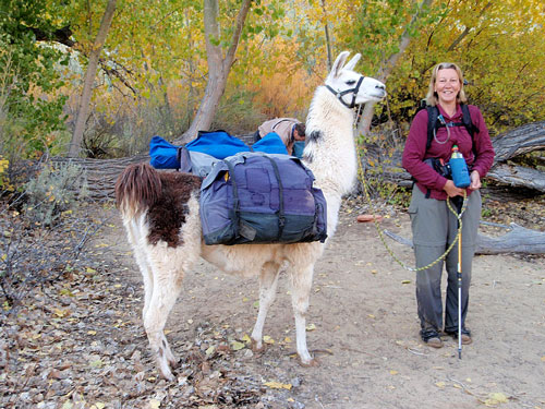
Kathleen with one of the self-propelled
cargo hauling devices.
