Trip Leader & Author: Dennis Brandt
Participants: Bill Priedhorsky,
Karen Grace, Terry Morgan, Jackie Little, Ron Morgan, Kathleen
Gruitzmacher, Tracy McFarland, Shelly Cross, Troy Matevia, Dave
Chamberlan, Jeri Sullivan, and Dennis Brandt
Original LAM Announcement: click
here
Participants
started at various times on Friday afternoon, according to different
work schedules and car pool arrangements. Cerro Pedernal is
approached via Forest Road 100, south from Youngsville. The final
stretch of road up Temoline Canyon is fairly rough and steep.
However, with careful driving no particular difficulties were
encountered by the heavily loaded vehicles, which included 4WD and
AWD SUVs and a 2WD pickup truck. Camp was set on a forested bench at
8940 ft. elevation, ˝ mi. SSW of Cerro Pedernal. This rarely-used
camp is suitable for several tents and affords a fine view of the
mountain.
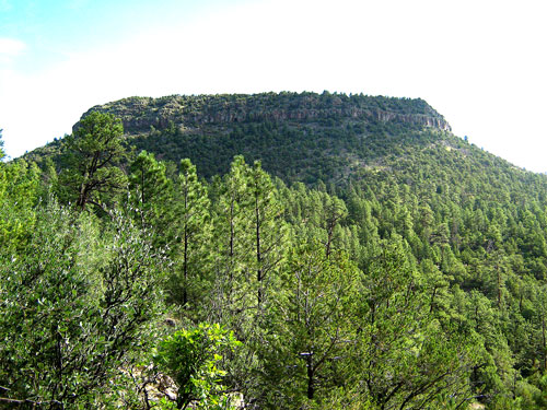
View of Cerro Pedernal from camp.
On Saturday our
party of twelve started out a little after 9:00. We traveled
cross-country in hot and sweaty conditions through a dense mixture
of scrub oak, juniper and pine on increasingly steep and loose
terrain. The final approach to the summit block is on a well-defined
but steep and direct trail. The key to the climb is locating the
12ft high, 3rd class break at the base of the basalt summit block.
This appears to be the only break in a monolithic vertical cliff
band that extends all around the Southwest facing side of the
mountain. The break in the cliff is easily found because it is about
100 ft NW of an easily visible square-shaped cave. All climbers made
it up the 3rd class section without the use of a rope, though some
were pretty nervous.
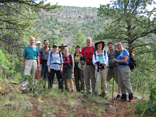
The climbers.
After the 3rd class
section, the route to the top is fairly obvious, and a little
circuitous. Care was taken to avoid knocking rocks on people below.
We arrived on top (elevation 9862 ft.) at about 11:00. Many were
surprised to find that Cerro Pedernal is not a flat-topped mesa, as
it appears from the more common viewpoints but is in fact a
remarkably narrow ridge that runs NW to SE. Once assembled, we
proceeded directly to the NW point to take in the views and have
lunch. Everyone was impressed by the views, which included the Ghost
Ranch basin, colorful sandstone cliffs to the northwest, and distant
mountain vistas to the southeast. We were also impressed by an
intense thunderstorm about five miles to the northwest. Fortunately
it was tracking to the northeast, but there was another storm
forming to the southwest that looked like it was aiming for us. So
we had a hasty lunch, walked quickly to the SE point and then back
to the descent trail. Cerro Pedernal is no place to be during a
lightning storm.
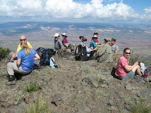
Climbers on top.
Once below the
cliff band, the descent was slow-paced due to the steepness and
looseness of the trail. It looked like we would be caught in a
rainstorm, but it held off. We returned to camp via a jeep road that
we intercepted below the northwest point of the peak. The road is
longer but easier to navigate than the morning approach route.
Six people broke
camp early Saturday afternoon and drove home. The remaining six;
Bill, Jackie, Karen, Dave, Jeri, and Dennis did some mountain bike
riding in the afternoon near camp, explored the agate outcrop that
Cerro Pedernal is named for, and had a comfortable evening dining
and sitting around the camp fire. Bill read a novel aloud for our
entertainment. There was rain during the night.
Sunday morning we
broke camp around 9:15 and drove south on Forest Road 100 to the
edge of Valle de la Grulla at 9700 ft. From there we rode mountain
bikes on a scenic 14 mile trip of intermediate difficulty that
included the circumnavigation of Cerro Pavo at 10,000 ft. Valle de
la Grulla is a beautiful alpine meadow in the Santa Fe National
Forest that is used for cattle grazing. Cerro Pavo is a thickly
forested mountain with occasional nice views of valleys and canyons
as well as a good view of Chicoma mountain. The route included an
all weather road, and rough dual track jeep road. Everyone enjoyed
the ride.
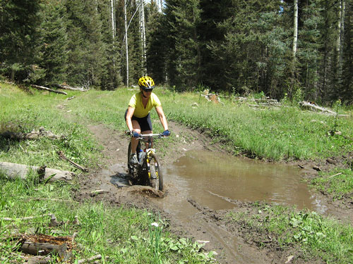
Cerro Pavo Jeep Road.
While driving home,
we passed beneath Cerro Pedernal just as it was hit by an intense
thunderstorm. It nearly disappeared from view under the downpour. We
were certainly grateful that we weren’t on the peak then.
