|
Llama Drop Camp, First and Main Canyon Complex
Grand Staircase-Escalante National Monument
October 6-15, 2006
Leader and Author: Bill
Priedhorsky,
bill@priedhorsky.net
Photo Gallery: Jan
Studebaker, Click
here
to view.
Map: Click
here to view
our hiking routes map (1.95 MB).
Trip Participants: Bill
Priedhorsky, Ginger Buckendahl, Karl Buckendahl, Dave Chamberlin, Karen
Grace, Kathleen Gruetzmacher, Elizabeth Kelly, Jackie Little, Allyn
Pratt, Dave Scudder, Jan Studebaker, Jeri Sullivan, Marilyn Yeamans
The Escalante country has
been a perennial destination for the Mountaineers. Why? The answer lies
in the square miles of slick rock, the perennial streams, and the llama
or horse packers that make for a luxurious trip, which have brought us
back spring and fall for several years running.
Our fall 2006 trip was a
challenge. We drove into a natural disaster in the Boulder area. The
local canyons flooded at the hundred-year level Thursday and Friday
before we arrived, as the town received about 3.8 inches of rain in 3
days, nearly half their regular annual precipitation. Deer Creek ran at
3,000 cfs, when its normal level is about 5. The downstream gauge on
Boulder Creek rose to 1,800 cfs and failed. Every dirt road in the
vicinity was washed out.
We left Los Alamos on the
evening of Friday Oct. 6, heading to Farmington for a head start on the
10 1/2 hour drive, making possible a day hike en route the next day.
When we called the packer Brian from Farmington on Friday evening, we
learned that the recent bad weather was not just a little rain, but
serious flooding. BJ, his clients, and their llamas were still missing
in Grand Gulch. When we checked again on Saturday morning, BJ's clients
had been brought out by the BLM rangers, but BJ, guide Tanya, and the
llamas were still in the canyon. Our car - Jan, Jackie, Kathleen, and I
- drove ahead to Bluff for breakfast, where the phones and credit card
machines were out, then waited for Jeri, Dave C., and Marilyn to catch
up. We hiked for an hour and a half in the slickrock west of Hite. In
Hanksville, we learned that the road to Torrey through Capitol Reef had
washed out, requiring a 100-mile detour to the interstate. The virtue of
the detour was our first ever view of the San Rafael Reef from the road
north to the interstate, and views of the heart of the swell as we
crossed on the interstate. Should this be a destination for next spring?
Our 5:30 PM rendevous with the Boulder packers was certainly out the
window, but Red Rock & Llamas guide BJ was later than we were. We met BJ
for a quick greeting on the highway west of Hite, waving him down when
we recognized the Red Rock trailer. Later, he was pulled over on the
interstate with a boiled over radiator after the long climb up the
Swell. Our last car met him a little farther down the interstate,
completely broken down, and picked up Tanya to drive her to Boulder.
With canyons flooded, more
weather predicted, and BJ still out, we made a Saturday evening decision
to postpone our departure by 24 hours. Brian and I racked our brains for
an alternative trip, since our Horse Canyon destination was likely
flooded and too far to reach, with the Sheffield Road out. Brian raised
the idea of Anton Ridge, but came up with a better idea at breakfast
Sunday - the high benches west of the Escalante, a couple miles short of
our original destination. While Brian and the packers recuperated on
Sunday, we had a lovely day hike in the Deer Creek country, and chanced
across Grant, who runs Escalante Canyon Outfitters, at the trailhead. We
found and swam in deep turquoise pools near the ridge top between The
Gulch and Deer Creek. Six of us drove to dinner at the Café Diablo in
Torrey, 35 miles away, for a fabulous dinner.
Our llama trip finally began
at the Red Rock & Llamas barn at 8 AM Monday. We were recruited to round
up our 14 llamas. Karl, who grew up on a New Zealand sheep station, had
llama wrestling down pat. Brian was now proposing plan D or E, camping
above the First and Main canyon complex rather than nearer the river,
because we could drive only 1.3 miles down the Sheffield road. We set
out hiking at 10:30 AM in intermittent rain. We bypassed their first
proposed campsite, an alcove in the pyramid west of Red Breaks, and
arrived at the Hot Dog tanks above First and Main at 2:00 PM. The
campsite was just 1 mile from the end of the road, but about 8 miles
from our starting point. Most of the hike progressed quickly, at about 3
miles an hour, down the damaged road. Although I wanted to push closer
to the river, Breck convinced me of the advantages of our campsite, with
hiking access to the spring to the east, First and Main, and the Red
Breaks.
We set up a sun shelter to
cover the cook tables, which proved handy as Jackie and Karen cooked a
Middle Eastern dinner in the rain. Carolyn, Allyn's sweetie, sent the
chocolate chip cookies. Twice the nearby wash ran, advancing slowly from
pool to pool, and finally over the drop to the canyon below. This
unfortunately muddied our water source.
We crawled out of our tents
at about 8 AM on Tuesday into mostly cloudy weather, and planned a hike
to the east. It had rained during the night. The day remained partly
cloudy, with dense clouds on the horizon. We left camp at 10 AM with a
view towards climbing the 5800+ peak northeast of camp, which appeared
highest on the skyline. We started up the slickrock ramp on the horizon,
with an unnecessary but interesting side trip along a sidewalk on its
north. Most of us then descended a big gully, then worked our way up two
plateaus and reached the summit for lunch. Hiking the slickrock after
heavy rain, we were at a heightened state of awareness. Not only was the
rock slippery, it was crumbly - water had saturated it throughout, and
it could break. Fresh rockfall was evident along our drive to Boulder,
and in the canyons of the Escalante.
After a false start down an
eastward ramp, which terminated in a cliff, we backtracked down the way
we came up, and found the pool/spring (strikingly cold) for a remarkably
short dip. Every time we turned a corner, new slickrock wonders - domes,
walls, and acres and acres of bare rock - opened for us. We split our
group after the swim, Kathleen and Allyn heeding the thunder and
beelining for camp, while the rest traversed a deep gash in the ridge to
the south, and cruised along the valley slope through a brief storm,
which ended with a double rainbow and glowing wet rock. Post-stew, we
sat around the campfire (we had a campfire every night), wrote a
personal ad for Dave Scudder, which he was highly unlikely to use, and
sang our way through our customized songbook. Karen and I choreographed
"YMCA".
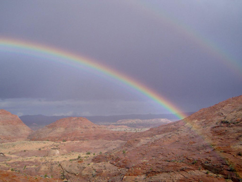
After a brief rain, a
double rainbow appeared to the east, in the direction of the Escalante.
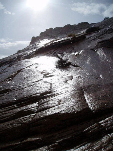
The slickrock glowed in
the sunlight after the rain.
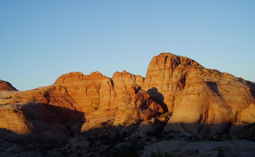
Wednesday dawned perfectly
clear. At this time of year, sunlight hits the tents just about 8 AM. I
don't remember another campsite nearly as scenic. The buttresses
northeast of camp look frighteningly rugged, but by the time the trip
was over, we had climbed nearly all their summits. Our Wednesday goal
was the canyon system known locally as First and Main, just over the
cliff north of camp. Access into the canyons was not obvious. Our first
try, down a short steep canyon recommended by Breck, looked too hard to
Karl and Jan. We backtracked to a more major side canyon and entered at
its head. I expected a long thrash through thick bushes. Instead, the
canyon drove into the earth as soon as we passed a large chockstone, and
we descended to a world of pools and mossy rock, smelling like a root
cellar. Most of the pools could be sidestepped or wedged past, but the
final pool required a knee-deep wade and emergence from a tight crack.
After at least an hour and a half in the underground, we emerged into
the brightness of the sandy (quicksandy) bottom, and had lunch at the
corner of First and Main.
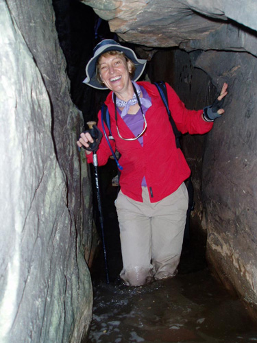
Karen emerging from
slot canyon squeeze, like Aphrodite from the waves.
Over the course of the
week, we reached every summit on the rugged ridge northeast of camp.
We hiked downstream, bathed,
then worked our way back upcanyon along a rising ramp, with the
intention of cutting back to First and Main. A little rope work and
hand-holding took us to the top of the ramp. Dead-ended from further
progress south, we frictioned up to the saddle (dotted with shallow
turquoise pools), then up a chocolate stairway to the highest peak along
the ridge, marked 5844' on the quad but named Little Big Peak by us to
honor Jackie's intrepidity. Five of us reached the peak; Kathleen rested
her knee in camp, and the rest turned back earlier. It took two hours
from the summit back to camp, exiting a ramp that was much faster than
our slot entrance. Dinner was Dave and Elizabeth's fresh salmon, rice,
and ice cream. With the Moon several days past full, we held an
astronomy lecture on the sand. The gegenschein was barely visible -
perhaps.
Thursday, October 12 was
Elizabeth's birthday. We left camp again at 10 AM, exploring the Red
Breaks country between camp and Harris Wash. The Breaks are broken slick
rock country, incised by canyons draining south to the wash. The canyons
get very deep, with some slots midway, opening again at the south end.
We started the hike by climbing the highest peak in the vicinity, a knob
of 6015', with surpassing views in every direction. Towards the
Escalante we saw a small temporary lake - an odd sight in the canyon
country. We proceeded south along the drainage west of 6015, following
it to lunch at a junction with a deep slot canyon to its west, then
another mile down the canyon with flat narrow sandy bottom and slanting
sandstone walls.
We crossed over the mesa to
the drainage to the east, descending past hoodoos, then washed in a
sun-warmed shallow pool. On the way up, we meet two guys and a dog from
Albuquerque, the only other humans that we saw on our trip. We reached
the divide via a round-bottomed sandstone section like the chute for the
giant ball in "Raiders of the Lost Ark". Back in camp the ladies cleaned
up with their sun-warmed sun showers, we ate pasta carbonera and bean
soup thanks to Ginger, and read a chapter from Edward Abbey's classic,
"The Brave Cowboy", around the campfire.
On our last full day of
hiking, Friday the 13th, we descended to First and Main with the
intention of hiking west along the bottom of Main - the major E-W canyon
- and finding our way out its top. We descended to the canyon via our
exit ramp from Wednesday, and the eleven of us (Dave and Jeri remained
at camp) hiked about 1/4 mile up West Main. We were stopped by a run of
slot canyon about 4 feet wide that was up to waist deep with no end in
sight. This was rather too cold for an October trip. We then split into
two groups, with Karen, Jan, Elizabeth, Marilyn, Dave, and I returning
to Little Big Peak (peak 5844), and the rest hiking down canyon to seek
a way around the massif northeast of camp. Jan and I shortcut the long
ramp to the saddle by free-climbing an exposed 4th class face. This got
the adrenaline going, and took about five tries to get started, but once
on the way up we found a fissure whenever we needed one. Jan and I
bathed in a pool atop the saddle, then we all hiked to the flat top of
Little Big Peak for lunch. Karl's sunglasses were where he left them, in
a bush on the summit plateau. We could see the rest of the party near
the river below. They were blocked from the Escalante by an immense
drop, tried to circle the massif, then turned back and returned the same
way they came in.
Our own party worked south
along the ridge and climbed each of the four peaks along the skyline.
Jan and Elizabeth climbed a block with about 500 feet of exposure in the
direction of camp; I started up, but turned back when the rock crumbled
under me. We called their high point "Ex-lover's leap", and the little
route up "Bill's Boo-boo".
We returned to camp by 5:30,
looking forward to Kathleen's chili dinner. A little after 6:00 PM, we
were surprised to see our packers, Brian, BJ, and Breck, arrive in camp.
It turned out that the Sheffield Road was still closed, leaving us with
an 8-mile outbound hike, rather than the 1-hour trip to the end of the
road. The chili stretched for all 16 of us. We held a song and dance
party around the campfire, energized by Elizabeth and Karen's movement
and Kathleen and Dave S.'s voices. Brian and Breck snuck off the bed,
and BJ claimed that he was too young to know the words of any of our
songs. There were patches of cloud across the sky as we turned in.
That night, the eve of our
departure, it rained hard and kept raining all the next day. It most
stopped for two hours at 8 AM, letting us eat breakfast and start
packing more or less in comfort, but it was raining hard before the
packing finished. The wash next to camp was roaring, but Dave S. leaped
across it to rescue the sun showers stranded on the far side. The slog
out was long and wet and cold - about 47°, and the road the road so
muddy it was hard to walk it. The hike took about 3 hours, arriving at
the trucks a little after 2 PM. On the way out along the Sheffield road
- just a 1.3 mile drive to blacktop - the big llama trailer was stuck
twice, requiring us to unload the llamas, jack it up, and put stones and
dirt under the trailer tires. We arrived at the motel at 5 PM, having
unloaded at the llama barn, much appreciating the warmth of the shower
and our rooms, while a 45° rain continued outside. As always the Boulder
Mountain Lodge hot tub eased our sore joints and muscles.
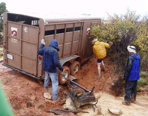
It took us almost two
hours to drive 1.3 miles out to the highway, thanks to adventures like
this.
This was a very physical
trip, with hard hiking every day. We averaged 7 hours per day on the
trail, although our greatest range from camp was barely more than 3
miles. The cool weather of autumn made this possible, with even the
clear days in the 60's. We could not possibly have covered that kind of
ground in the hot weather of a May trip. Despite the weather hardship,
it was a rare treat to see every pool filled and every wash running. We
agreed that we would not choose such raw weather, but it was an
experience not to be missed.
The llama services - picking
up and dropping off 14 llamas worth of gear, each carrying a net payload
of 73 pounds - cost us $260 per person, including a tip of 20%. Red Rock
and Llamas can be reached by contacting Bevin McCabe at (877) 955-2627
or rllama@color-country.net;
the local lead in Boulder is Brian Dick at (435) 335 7421. Most of us
stayed at Pole's Place in Boulder for the two nights before the trip and
the night after. Rooms were in the $70 range with tax, and can be
arranged by calling the proprietor, Camille, at (800) 730-7422. A few of
us stayed at the more luxurious but more expensive Boulder Mountain
Lodge, (800 556-3446).
Photo Gallery: Jan
Studebaker, Click
here
to view.
Map: Click
here to view
our hiking routes map (1.95 MB).
|
