|
Dark Canyon Backpack, Utah
September 13- 17, 2006
Leader: Bill
Priedhorsky
Author: Jan
Studebaker
Photo Gallery: Jan
Studebaker, Click
here
to view.
Maps: Click
here to view
the approach map (1.7 MB). Click
here to view
the area map (1.3 MB).
Trip Participants: Bill
Priedhorsky, Karl Buckendahl, Jackie Little, Karen Grace, Martin Staley,
Dave and Greg Scudder, Greg’s friend Kelsey, Dave Chamberlin, and Jan
Studebaker
Bill Priedhorsky organized this short but
wonderful trip to Utah Canyon Country. Bill was apparently trying to save
his vacation for one of his other many adventures, and saw that it would be
possible for him and several friends to use just one day of vacation and get to
spend three overnights in Dark Canyon. Considering that driving time took
us a good part of two days, this was definitely a good plan for us all.
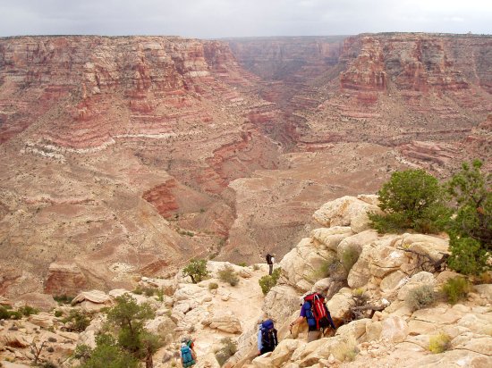
Beginning the 1300' descent into Utah's Dark Canyon
Getting there: Dark
Canyon is surely one of the deepest canyons in Utah, and it is certainly
no small challenge to get into. We took the Sundance Trail to gain
access to this incredible area. The hardest part of this otherwise
difficult four mile hike was finding the trailhead; we used a
combination of information resources to do so. I found a trail
description in Ron Adkison's "Hiking Grand
Staircase-Escalante & the Glen Canyon Region" guide book that included
step by step instructions for finding the trailhead. We probably
followed Adkison's description, but the
roads were many, so we may have used a bit of luck as well. We
were fairly sure that we had arrived at the trailhead when we passed a
"stock" pond just before the end of our road spur.
Adkison had made a point of mentioning this
landmark; however, it would have been much less visible had it not been
full of water. We walked in a circle around the parking area and
found no trailhead marker of any kind; no sign, no trail register, and
no cairn, so we took a bearing on the route and started walking in that
direction (~north by north east). Shortly we found two separate
trails with cairns running in the correct direction and parallel to one
another. These both led to a slickrock plateau from which we could
see the road that Adkison had referenced.
We down climbed a bit of clean rock to get to the valley floor and
headed to the road. We followed this road west for a short
distance and found a trail, with accompanying trail marker, that
continued in the correct direction; this took us to the rim of
Dark Canyon and our extremely steep 1300 vertical foot descent through a rubble strewn
and loose landscape. Bill also used a newly revised USGS topo that
showed the Sundance trail, but the older topos that I found showed no
trails leading to our descent. I believe we would have been
equally well served had we picked up the Trails Illustrated map called
"Dark Canyon and Natural Bridges National Monument".
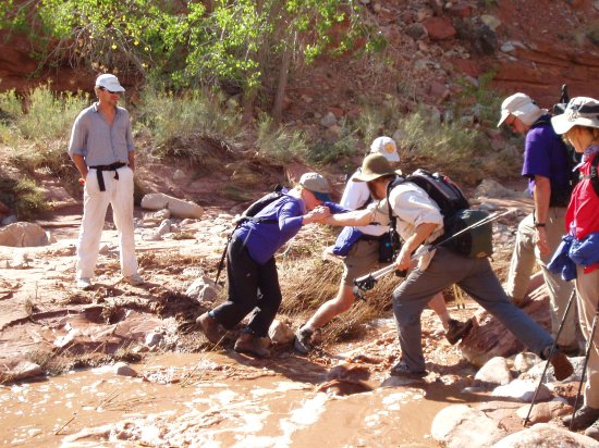
One
of many muddy stream crossings
The adventure: the
1300' descent into Dark Canyon (from the rim) was difficult with packs,
but it was over in less than two hours. The view into the canyon
was awe inspiring when we dared look up from our feet. After we
reached the bottom we began a short search for a good base camp.
After a series of swollen stream crossings, and hiking about 0.6 miles
up canyon, we found a suitable bench that offered adequate vertical
protection from possible flash floods, and room for our many tents.
One of the lower benches was ruled out due to obvious recent flooding.
The perennial stream in Dark Canyon ran with uncharacteristically muddy
waters for all 4 days of our stay. On two previous trips to this
area the clear water was truly a joy to wade through, but this time we
tried valiantly to avoid walking in the reddish-brown syrup because we
were unable to see the bottom.
During our stay we hiked
as a group along parts of Dark Canyon, Lean-To Canyon, and Lost Canyon.
We never got very far due to a rather lazy and laid-back group attitude,
but this made for a relaxing trip and a change of pace for all of us.
We stopped frequently on our excursions, had numerous snack breaks, dips
in pools, and water pumping sessions. Stream crossings were common
and slowed us down, as did numerous short and often exciting climbs to
stay out of the water.
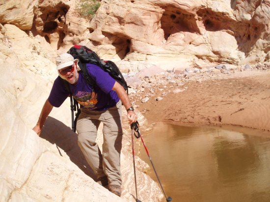
Bill
wondering how he got into this predicament
The water was so dirty
that it completely clogged Dave Chamberlin's First Need filter in a
single day of pumping. Our gravity filter did better but required
some cleaning. We found that pot holes of trapped water were far
less murky so we used them often, sometimes carrying heavy backpacks of
water filled bladders back to camp.....thank you Bill and Karl!
One evening was a bit
rainy at dinner time, and one night was best described as a dust storm.
The dust was most unpleasant, filling our eyes and our tents with grit.
Bill felt that sleeping under the stars, rather than in a tent, was less
annoying in the tent flapping and sand driven wind. Other than
that, the
weather was perfect! This trip will be fondly remembered by all,
and revisited frequently in our memories! I am certain that some
of us will return, more than once, to Dark Canyon.
-
Click
here
to view our "Dark Canyon" gallery
-
Click
here to
view a map showing the Sundance Trail access (1.7 MB)
-
Click
here to
view a map showing the entire area of our Dark Canyon adventure (1.3 MB)
|
