Leader:
Dave Yeamans
Trip Participants:
Los Alamos Mountaineers
Author:
Jan Studebaker
Photo Gallery: Jan Studebaker, click
HERE to view our
"Cabezon Volcanic Plug" gallery
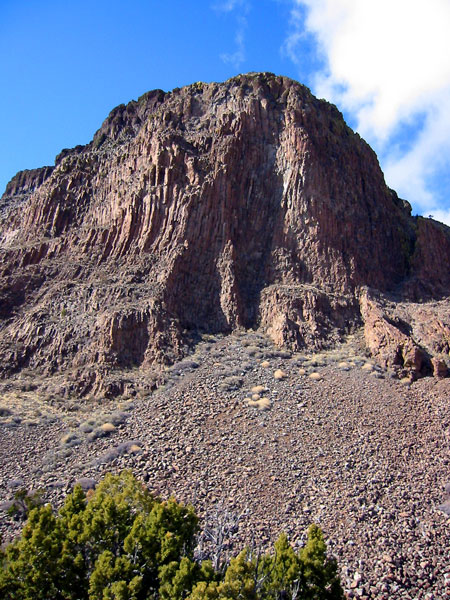
A small group of intrepid climbers happily joined Dave
Yeamans for a beautiful and exciting climb of Cabezon Peak near Cuba, New
Mexico. The name "Cabezon" is derived from the Spanish noun "cabeza," meaning
"head," and "Cabezon" translates as "big head." The peak is believed to have
religious significance for the Pueblo and Navajo Indians, and remnants of their
visits still exist. The Navajos have various myths associated with Cabezon, one
of which explains that the peak and local lava flows came from a giant who was
slain upon Mount Taylor. The giant's head became Cabezon Peak and his blood
congealed to form the Malpais, or the "bad land" volcanic flow to the south.
Jan's photo
of Cabezon Peak was published
in the January 2006 issue of "Nature Materials"
The photo gallery
below illustrates our March 5, 2005 climb. We were joined by several
paragliders, which we watched as we climbed. Cabezon Peak's dramatic
volcanic formation is one of the most well known landmarks in northwest
New Mexico. With an elevation of 7,785 feet, the Peak is part of the
Mount Taylor volcanic field and is the largest of 50 volcanic necks rising
from the Rio Puerco Valley. Dramatic basaltic cliffs on Cabezon provide a
close view of an ancient volcano. Several of my photos were purchased for
promotional use by the paraglide company that was flying during our climb.
The
Climb:
Cabezon, rising nearly 2,000 feet above the valley
floor, is a popular area for rock climbing and scrambling. The ascent of
the 4th class chimney near the southeast portion is marked by cairns. A
70 foot 9mm rope is useful for hip belaying inexperienced climbers. A
successful climb to the summit will reward you with an expansive view of
the Rio Puerco Valley. Helmets and sturdy boots are recommended
when climbing the peak due to loose rocks.
Getting There:
Entry into
the area is best gained by turning westward from US 550 onto CR 279
approximately 20 miles northwest of San Ysidro. A green
highway sign (labeled "San Luis - Cabezon - Torreon") marks the turnoff. Continue 12
miles (southwest past the village of San Luis) to the Cabezon turn-off,
onto BLM Road 1114. At the intersection of CR 279 and BLM 1114 you will
pass by the privately-owned "ghost town" of Cabezon. Follow BLM 1114
south for 2.9 miles to the dirt route that leads east to the trailhead.
Four well
drive vehicles are
recommended on the unmaintainted dirt road. Also, CR 279 and BLM 1114 are
passable during dry conditions, but they can become slippery and rutted
during wet seasons.