Author: Bill Priedhorsky
The Los Alamos Mountaineers have adventured many times in the
canyon country of southeastern Utah and northern Arizona. I myself have shared
in a great many of these adventures. This is the story of my 65th trip, almost
25 years to the day after introduction to the canyons in the fall of 1979.
Twelve of us explored the canyons and slickrock country of the Grand
Staircase-Escalante National Monument, spending 6 nights at a campsite above the
junction of Willow Patch and Sand Creeks. These are a few notes about our
adventure.
As was usual for the trips that we used to call
"Canyon
Country for Broken-Down Baby Boomers" (until the joke started to sound a little
too close to home), our trip was based on a horse drop camp. We hired Bob and
Sioux Cochrane of Boulder Mountain Ranch (435-335-7487) to haul our gear from
the trailhead to our base camp. From the base camp, we explored out on day hikes
into the rough and magnificent slick rock and canyons.
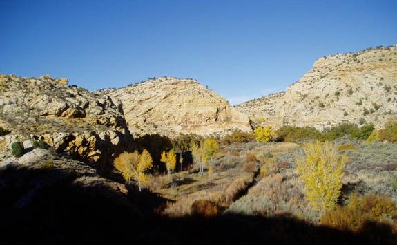
Our base camp was atop the middle point in this
picture. The flat at the junction of
Willow Patch and Sand Creeks, with their fall-colored cottonwoods, is in the
foreground.
In an attempt to get more of a good thing, we stretched this
fall's trip to a full week, spanning the Columbus Day holiday. The members of
our expedition converged on Boulder, Utah from all directions. Bill Houghton
(former president of the Colorado Mountain Club) and Mary Smith came from
Colorado Springs; John Meier and Kirsten Larsen from Park City, Utah; my high
school friend Rosemary Irvin from Seattle; Ginger Buckendahl from Flagstaff,
Arizona; and Karen Grace, Kathleen Gruetzmacher, Marilyn and Dave Yeamans, Dave
Scudder, and myself from Los Alamos. The Los Alamos gang hit the road at 6 AM on
Saturday October 9, spent about 1 1/2 hours hiking in the vicinity of Lake
Powell, and arrived in Boulder about 5:30 PM, for a total drive time, via
Hanksville, of a little less than 10 hours. We had a wonderful dinner at the
Hell's Background Grill at the Boulder Mountain Lodge, then a leisurely morning
with an 8 AM breakfast. This was a good thing, as we had averaged two to five
hours sleep on Friday night, what with packing and the early start (3:30 AM
airport shuttle for Rosemary).
Bob and Sioux Cochrane had picked up our gear at the lodge at
7 PM the night before, which gave them the night to pack for their horses. Our
load was not insubstantial - we filled up 7 pack horses, which are good for up
to 150 pounds apiece. The cost for the Boulder Mountain Ranch packers, including
a dinner that they brought for us our last night in the canyons, was $205 per
person including tip - still a bargain.
We reached the Boulder Mail Trail trailhead by about 10:30
AM, and were loading our day gear as the packer rode past. We followed the same
route as the packers to camp - down the Mail Trail nearly to Sand Creek, then
traversing south along the benches to the triangular piece of land between and
above Willow Patch and Sand Creeks. We stopped for lunch, and made a side
excursion to the natural arch along Sand Creek about a mile above the Willow
Patch confluence. When we reached camp at about 3:15 PM, we found our gear
neatly arranged below a tree, on a dry bench with no obvious route to water. We
of little faith doubted Bob Cochrane's judgment as to the campsite. But, after a
couple hours of exploration, we found that (1) the campsite was indeed well
chosen, at the last flat spot before the drop to the creek, and (2) there was a
reasonable route to water in Willow Patch, necessitating a round trip hike of
about 20 minutes. We would have been better prepared if we had more ways to
backpack water, rather than carry it by hand in open buckets, but never ran
short. The horses would have been unable to make the final rough descent to Sand
Creek, and a camp along the creek would have been cold at night, as we found in
a backpack to the confluence in October 1999. As it was, the weather was often
cloudy and cool, and one night spattered a few drops of rain. We did not have
the warm weather that was the rule for other October trips, which were slightly
earlier in the month.
From the bench top camp, we had a clear horizon, and enjoyed
the starry moonless sky. I carried in a 4 1/2" Astroscan telescope, which we
used to see the Andromeda galaxy, the Orion nebula, the Pleiades, etc. We were
all happy with a relaxing adventure - typically, our hikers left camp at 10:00
AM each morning, although on our first outing, exhausted from work and the
effort of getting underway, we struggled to get going before noon. The terrain
was extremely rugged, so, even if our goal was just a mile from camp, we had
plenty of new vistas and challenge.
On the morning of our first full day, Monday the 11th, we
took a short hike down from our promontory to Sand Creek, and up onto the rib on
the far side. This involved scrambling up some steep loose rocks. Dave Scudder
bravely led the route, then threw down a safety rope for the rest of us.
Rosemary quickly learned that the word "hike", in the Utah context, mean
something different than a stroll through the Northwest woods. We followed the
spine of the ride to the top of a dome, with a friction climb up a steep
sandstone slope, and gained our first big views of the Escalante country. On the
way down, we tried to avoid climbing the spine by following the drainage on its
west side. However, we found the willows that filled this drainage from wall to
wall to be impenetrable. Fortunately, there was a simpler way down the spine to
Sand Creek, which required a belay for only a single move down a corner.
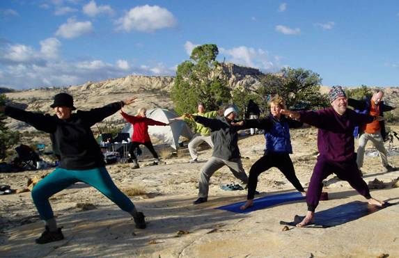
Base camp life had a certain degree of comfort,
with stoves and chairs (background), and an informal morning yoga class
led by Karen (blue jacket). The author is in purple on the right. Some of our
day hiking destinations can be seen on the far skyline.
We split the party for subsequent days. Typically, a few
folks would spend the day around camp, perhaps taking photos and visiting the
clear stream and cattail swamps along Willow Patch. A smaller group would day
hike along the cottonwoods and crystal water of Sand Creek, sometimes looping
far above the stream, across the slickrock and high country, in order to move up
or down stream. The largest group, ropes in their packs, would head out for a
hiking/scrambling adventure. On Tuesday, they headed to the top of a small rocky
mesa atop a sweep of slick rock across Sand Creek, downstream of camp.
Wednesday's expedition was more rugged, climbing a rocky dome to the southeast
of our camp. Lunch was on top of the dome, amid iron-red boulders that looked
like foundry scrap. The first attempt to climb down was abortive, ending at the
top of a sheer drop. Another route off the dome was successful, although Dave S.
of course found the hardest way down, chimneying a steep slot. The group then
hiked up the upper drainage of Sand Hollow, which parallels Willow Patch to the
south. At the top, they crossed into Willow Patch, but found the vegetation too
thick to make progress downstream. This required another chimney climb out of
the drainage, and a return along the bench top to camp. Our Thursday hikers
chose distance rather than steepness, and hiked across the bench west of Sand
Creek to a point where they could look down into Death Hollow - a destination
for trips in previous years.
Most of us hiked out together for our last full day in the
canyons. Our goal did not seem too formidable - we just wanted to reach the top
of the two "tetons" that we could see from camp, south and west across Sand
Creek. Our hike took us up a slickrock drainage, and across the bench to a rib
that looked gentle enough for an easy ascent. Not surprisingly, the rope soon
came out to belay folks up the jam cracks, through the upsloping friction face,
and across a traverse when the route shifted from one side to the other. We
succeeded to the top, first to a huge slickrock plain, many acres across, then
to the tetons themselves.
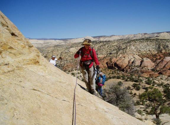
Marilyn uses a hand line for a traverse as we
climb up a rib on the way to "les deux tetons".
McGath Point, where the Boulder Mail Trail begins, is the slickrock expanse in
the background.
From the twin tetons, we hiked across and up the slickrock to
Tuesday's mesa, then to the top of another, solitary teton, which we named for
the raven which we chased from its summit. The route down and south from raven
teton looked impossible, but each downward level opened to another, until we
were able to rope a last short drop and cross to the plain to the south. Dave
and Bill, well-trained from a summer mountain run, used their excess energy to
race across the hollow to the next saddle, then hiked more sensibly across Sand
Creek, to the base of the climb back to camp. Fortunately for those downwind,
they used the sun showers that we had set up at the base of our climb to camp,
where the hikers washed up each evening.
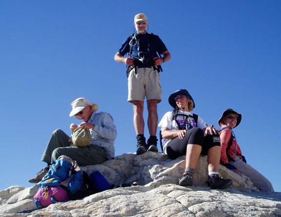
Dave Yeamans, Dave Scudder (standing), Kathleen,
and Karen atop the "Raven Teton". Brave Ginger, just out of the picture, also
made the top.
Trip by trip, our canyon novices have become familiar with the challenge and joy
of navigating the slickrock terrain.
By the time we returned to camp, for our bittersweet last
evening in the wilderness, Bob and Sioux Cochrane had arrived with some of their
horses. They prepared us a steak dinner, complete with a birthday cake for Bill.
This was a first of celebrations for Bill, followed by the candles and singing
the next night at Boulder Mountain Lodge.
The outward hike on Saturday took a little over 4 hours. It
involved a hike along the bench north of Willow Patch to the base of McGath
Point, then a friction climb up the slickrock, passing below two outcroppings
that deserved the name of "Shortp*ck*r Rocks". As we ate our lunch atop a big
slickrock expanse, the weather seem to close in, getting much colder and darker.
When we finally reached the top level of the mesa, Dave and Bill handed over
their packs and ran for the cars, which they reached in about 45 minutes. By
driving the cars back, they saved the rest of the party the last flat 1 - 1 1/2
miles of the hike. We checked in to the Lodge, cleaned up, bought beer, and
spent a good part of the afternoon in the hot tub before a wonderful dinner,
again at Hell's Backbone Grill.
The 6 folks returning to Los Alamos left at 7:30 AM, and
stopped for a 1-hour hike up Surprise Canyon in Capitol Reef National Park. This
is a canyon carved into Capitol Reef, reached from a trailhead on the Burr
Trail, just beyond the switchbacks that descend the reef. We caught the 11:00
ferry at Bullfrog with a few minutes to spare. Stopping for lunch at the Twin
Rocks Cafe in Bluff, and dinner at the Abiquiu Inn, we reached Los Alamos a
little after 9:00 PM. Plans for the spring 2005 adventure are already underway,
and there will be other occasions to visit the canyons between now and then,
like our February 2005 visit to Bluff and surrounding country. But for now, we
all face the challenge of re-entry into "normal" life - but we knew that what we
left behind in the Utah canyons was the real world.
