|
Exploring the Country of the
Ancient Ones
February, 2004
Author:
Bill Priedhorsky
The canyon country of
southeastern Utah has about the most spectacular scenery to be had in this
country, or on this planet. It is also chock full of ruins from the 12th
and 13th century Anasazi people. A comfortable base for exploring the
wild country is Bluff (settled 1880), Utah, an agricultural village on the San
Juan River. Bluff is less than 6 hours from Los Alamos, making it a good
destination for a long weekend's outing. The Los Alamos Mountaineers recently
took advantage of this proximity. Forty-two club members spent the President's
Day weekend in Bluff, hiking to their hearts' content in the surrounding canyons
and mesas. This is the story of their adventures.
As one travels through
Utah from the Four Corners to the canyon country around Lake Powell, Bluff is
one of the last outposts of civilization. As one approaches from the east, along
the San Juan River, the last farm plots end at Bluff, and the country opens into
wild canyons and mesas. We knew we had arrived in Bluff when we saw the 300-foot
sandstone bluffs that tower to the north of town. The bluffs, of course, give
town its name.
Bluff's 300 people live
on the north bank of the San Juan River. Everything on the south bank is part of
the Navajo reservation, whose 25,000 square miles reach from Bluff nearly to the
Grand Canyon.
Primitive camping is
possible almost anywhere on the Bureau of Land Management territory north and
west of Bluff. But for a winter trip, when nights near freezing even if the days
are often in the 50's, civilized evenings and nights are tempting. For our Feburary trip, we stayed in the Recapture Lodge and the guest house rented by
Far Out Expeditions, and headed into the wilderness for day hikes. This gave us
the best of both worlds.
Although the Los Alamos
Mountaineers have been active since 1952, a 42-person trip was the largest that
any of us could remember. Organizing a trip of this size was a challenge,
because the interests and capabilities of the participants varied widely. Ages
ranged from 3 years to sixty-something, and technical skills ranged from rock
climbers to casual hikers. The solution lay in delegation. A hike of 42 persons
is impossible to run safely, and hardly a wilderness experience. But by
splitting the party four ways, with an experienced leader on each team, we
accommodated everyone. At 9 o'clock each morning, the hiking leaders took their
place in the parking lot of the Recapture Lodge, with a sign on their car
announcing their hike for the day. Participants signed up for the day, and the
hikes rolled out in their various directions in squads of 2-3 cars.
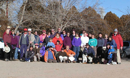
The
Los Alamos Mountaineers, at the Recapture Lodge in Bluff, Utah, about to
set out on a day's hiking through the nearby canyons and mesas. Most of
the participants are shown here; they made for the largest trip ever
organized by the Mountaineers. Photo courtesy David Scudder.
Although Bluff is just
213 miles in a straight line from Los Alamos, no road takes you directly there.
This is part of the wonderful remoteness of the Utah canyon country. The way to
Bluff wraps around the north side of the Jemez mountains, past the red rock
bluffs of Abiquiu and Coyote, beelines to Farmington on US 550, then jigs and
jogs past Shiprock and Four Corners to the San Juan valley and Bluff. A nice
meal stop on the way is the Three Rivers Eatery and Brewhouse in Farmington,
with several site-brewed microbrews (take a growler jug with you!) and
diner-type meals. The restaurant on the corner is more family-friendly than the
bar in mid-block.
The most exciting hiking
destination in the vicinity of Bluff is Comb Ridge, a monocline 700-800 feet
high which runs north-south for over 30 miles. US highway 163 crosses the ridge
just 6 miles west of Bluff. Butler Wash parallels Comb Ridge on its east side,
and an all-weather dirt road follows the wash from highway 163 north to highway
95. The Butler Wash road gives access to ruin-riddled side canyons that incise
the east side of the ridge. Comb Ridge is a classical monocline, rising gently
on its east side, through inclines and domes of sandstone, then dropping
suddenly in an unbroken line of cliffs on its west.
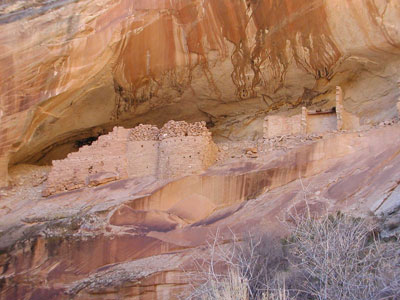
Our day hikes visited
several of the side canyons and their ruins, including the Processional
Petroglyph panel, on which more than 170 small figures are lined up as if on
parade. A particular highlight was the ruin in Monument Cave, shown in the
photograph. Most of the ruins on Comb Ridge date from the 3rd phase
of the Anasazi, also known as the Ancestral Pueblos, whose descendents still
live in the Rio Grande pueblos. The heydays of the Anasazi were the 12th
and 13th centuries. Sometime after 1300 A.D, the Cedar Mesa/Comb
Ridge area was abandoned, leaving the ruins that we see today.
Monarch Cave ruin, tucked into a side
canyon on the east side of Comb Ridge,
is a beautiful example of
late Anasazi architecture.
Like most hikes to the
Comb Ridge canyons, we reached our trailhead by driving a few miles up Butler
Wash Road, then crossing the brushy, overgrazed and over-cowpooped, muddy wash.
Beyond the wash, Comb Ridge rose in a gentle ramp, dissected by small canyons
like the one that hides Monument Cave. Our trip came just after a snowstorm, and
it was obvious by the lay of the snow why the Anasazi picked their sites. The
north-facing slopes were covered with snow, and the little stream at the bottom
was a series of frozen ponds. But Monument Cave, facing to the south, was warm
in the sunlight. The rockwork of the walls was as intricate as the better-known
ruins in Chaco Canyon. The mud mortar between the major stone courses was
chinked with smaller stones, and the windows and doors were still supported by
log lintels. Small artifacts were scattered around the site - bits of pottery,
stone blades, corncobs, and even a small knot tied in yucca fiber. The
surrounding walls were decorated with painted handprints. The handprints that I
have seen elsewhere in the canyons, and elsewhere along Comb Ridge, are usually
reddish in color. But these were an intense emerald green.
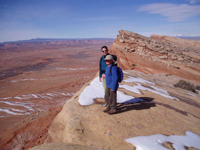
Micheline Devaurs and Petey Priedhorsky
look over the edge of Comb Ridge. The hike up Comb Ridge from the east is
a steady climb up gently-tilted sandstone, but from the top, the ridge
falls away in hundreds of feet of sheer cliff. A large piece of southeast
Utah is visible from the ridge top, including the Bear's Ears (left) and
the Abajo Mountains (right) on the far skyline. The vegetation marks the
course of Comb Wash, with Cedar Mesa beyond it to the west.
Leaving the ruin behind, we
continued up the gentle slope to the Navajo Sandstone cap of Comb Ridge. We
slogged up the long slope - a comfortable angle to hike, even for the greenest
hikers - and suddenly the ridge gave way before us. Several hundred feet below
lay the next drainage to the west, Comb
Wash. About half the drop to the bottom was a sheer cliff, underlain by steep
talus slopes covered by boulders, some as big as a house, that had fallen from
the ridge. Beyond the wash was a broken rise to the flat high country of Cedar
Mesa, dissected on our east side by numerous canyons, with names like Lime,
Road, Fish, and Owl. Several of these are worth multi-day trips, but that is
another story,
While two or three hiking
groups were exploring Comb Ridge, another party visited Citadel Ruin on Cedar
Mesa. In contrast to the bare desert below, Comb Ridge is covered by a pinon/juniper
forest (still fairly healthy, in contrast with our local forests). Cedar Mesa is reached from the south by a blacktop
highway from Mexican Hat. Most of the highway is a high-speed road, but it is
interrupted by 3 miles of winding gravel switchbacks that climb 1000 feet in a
section called the Moki (old) Dugway. From the highway beyond the Dugway, a dirt
road wends through the pinon/juniper to a gentle drainage, where the hike to the
Citadel begins. After a couple of miles along the gently falling dry streambed,
the ground dropped away. We were at the edge of the main canyon, and could see a
narrow stone causeway crossing the void to a promontory. The route to the
Citadel ran along this causeway, which was perhaps 20 feet wide, and blocked in
two places by the remains of rock walls. These defenses hinted that the Citadel
was not built in peaceful times. The Citadel itself is a south-facing,
multi-roomed structure, completely intact in all its rockwork. The walls are
complete from the bedrock floor below to a rock ceiling above. Around the corner
is a small dam that once held a reservoir, perhaps to hold water in times of
siege. Atop the rock cap of the promontory was a small wall. Behind that wall, a
lookout could watch the causeway without being seen in turn.
Our hikes to Comb Ridge and
Cedar Mesa occupied us for two days. In the evenings, we crowded into the
commercial-scale kitchen at the Far Out Expeditions guesthouse, and shared a
potluck dinner to celebrate our day. There is one restaurant in Bluff offering
good food, the Twin Rocks Cafe, but we thought a big get-together would be more
fun - - and it was!
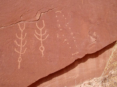
Corn petroglyphs in lower Butler Wash.
If you go: The
Recapture Lodge is the traditional meeting point for adventurers in Bluff. New
Mexico author Tony Hillerman mentions it in A Thief of Time, one of his
Navajo country mysteries: "The Recapture Lodge had been Bluff's center of
hospitality for as long as [Joe] Leaphorn could remember". The Lodge is rustic
but homey, and offers free interpretive slide shows and an outdoor pool during
the season, a hot tub all year, several kitchen units, 100 acres of riparian
open space bordering the river, and area information and maps in a tranquil
atmosphere. Rooms are inexpensive (in the $40 range) and pets are welcome. The
Recapture can be reached at (435) 672-2281 or found online at
http://www.bluffutah.org/recapturelodge. More elegant lodging in Bluff can
be found at the Calf Canyon B&B, in a historic building in downtown Bluff, at
(888) 922-2470 or
http://www.calfcanyon.com/. Far Out Expeditions rents a guest house for $150
per night (435 672-2294 or
http://www.faroutexpeditions.com/). The guest house sleeps twelve in two
bedrooms filled with bunkbeds. The kitchen is large and well-equipped, easily
supporting dinner for 30+. The Recapture Lodge, Far Out Expeditions, and other
organizations offer guided tours in the canyon country around Bluff.
On the heels of some
closings, the only year-round restaurant in Bluff is the Twin Rocks Cafe (435
672-2294,
www.twinrocks.com, open until 8 PM). Our party found the Twin Rocks'
offerings to be excellent. Two hours short of Bluff in Farmington, the Three
Rivers Eatery and Brewhouse (505 324-2187,
http://www.threeriversbrewery.com/) has offered good food and a range of
microbrews since 1997 at 101 East Main Street.
The Los Alamos
Mountaineers have been active since 1952 as an all-purpose outdoor organization,
with activities that range from technical climbing to casual hiking. We offer
an active, year-round schedule, and welcome new members. Membership information
and trip offerings can be found at
http://www.losalamos.org/climb/zLAMC.html. The Mountaineers are committed to
safe outdoor practices.
Copyright Bill Priedhorsky 2004
|
