Author:
William Priedhorsky, with input from KG and SC
Trip Participants:
Karen Grace, Shelly Cross,
Dennis Brandt, Elizabeth Kelly, Jan Studebaker, Cosima Leedom, Noor Khalsa, and
Han Htoon.
Photo Gallery: Jan Studebaker,
click here.
This is the story of four fabulous nights backpacking in
the Grand Canyon, led by Karl Buckendahl, with local organizing by Bill
Priedhorsky.
My biggest concern with November outings is the short
days. In the Grand Canyon on November 7, sunrise was at 6:57 AM and sunset at
5:27 PM. However, the 8th was the night of the full moon (and a lunar eclipse),
so the nights were hardly dark. In fact, on our one clear night, I noticed
colors in the night more strongly than ever I had before. So we had fun in the
evenings, cooking, talking, and playing games, and those who wanted could find
things to do until a respectable bedtime of 9 PM or so. The weather was somewhat
cloudy for the whole trip, with rain on our third night out.
The out-of-towners converged on Flagstaff on the evening
of the 6th. Several folks slept on the Buckendahl's floors; the rest at the
nearby Hampton Inn. The most creative mode of travel was taken by Bill, Karen,
and Shelly, who rode Amtrak from Lamy to Flagstaff and back. This was a relaxing
way to go; five shopping bags of snacks from Whole Foods, and a couple bottles
of wine, helped. We got into the canyon frame of mind by viewing slide shows
from past trips, including the recent October outing to Sand Canyon. I was so
nostalgic that I nearly cried. Amtrak was an hour late, which is not atypical;
we arrived about 11 PM. Lesson for next trip - take a taxi to Karl's house or
the hotel. Our return taxi cost only $5!
Karl had intended a fast start, by requiring everyone to
report for breakfast at Brandy's in Flagstaff, near his house, at 6:30 AM. With
breakfast and the drive, it was still about 9:45 when we started down the Tanner
trail, and 10 AM when Karl and Dennis, who set up the car shuttle, followed.
Tanner trail was somewhere between 7.5 and 9 miles long,
depending on which map or guide one believed. The initial descent from the rim
was a steep, treacherous, and bouldery mile or so, followed by a long level path
past Escalante and Cardenas Buttes. Quote from Karen reading the guide for this
piece of trail: "I don't think I can do this!". But the guide was overstated,
and she did just fine. Moral: hiking poles help. To quote "Animal Farm": "Two
legs bad, four legs good". Tanner features a particularly easy descent through
the Redwall. By the time we reached camp at the river, we were all tired and
footsore from the extended downhill. To ease his sore feet, Han finished the
hike by walking backwards. We arrived at camp between 4:30 and 5:30 PM, with
just enough light remaining to set up camp.
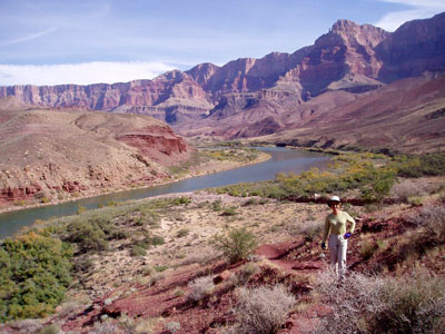
Bill dancing along the cliff
edge, at a viewpoint atop the Redwall,
with a view in the background to Tanner Rapids and our first night's camp.
This trip featured a lot of time of trail, with time to
discuss the meaning of life, relationships, etc. Elizabeth and I decided that a
key question was "in which ways are you growing?" We posed the question to Karen
the next morning; she said to ask her after coffee.
The route between Tanner Rapid and the foot of Red Canyon
was 11.2 miles, with sections of double black diamond difficulty. More on that
later. With packing and eating, our 7 AM wakeup translated into a 9:00-9:15
departure. The route went along the river flats, then climbed to an elevation
more than 1000 feet above the river. Fabulous views of the river and canyon were
everywhere, as shown in the picture below. A high point was the view of Unkar
rapids from a cliff directly above. The trail wound in and out of side canyons
as it stayed nearly on a contour, finally crossing Escalante Creek at an
altitude more than a thousand feet above our next camp. Our weary, sore, but
cheerful band straggled into camp between 4 and 5 PM. Bill threw down his pack
and jumped into the icy Colorado - it was tingly but very refreshing.
It had taken us all day to cover 8 1/2 miles. Karl kindly
went back at one point to take a pack; Karen took him up on his offer, for a
half mile of relief. We camped on a beach next to a huge eddy pool, below the
rapid that is just above Nevill's rapid. Han had now hiked two days with new
boots and cotton socks, and his feet were in rough shape. Dennis repaired with
athletic tape; our vision was of Han snoozing in his tent, with only his taped
feet sticking out the doorway.
Sweep of the river looking
upstream, back towards
Tanner rapids, as we climbed uphill on the second day.
Although Karl would have us move camp again, mutiny
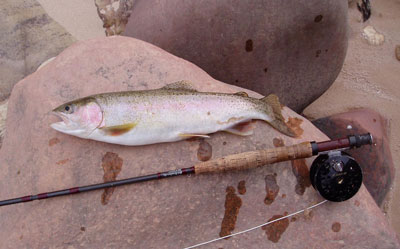
prevailed. We decided that a rest day was deserved. Bill set up his fishing rod
and, on the 3rd day of the trip, finally got into some serious fishing. Shelly
said that she would like a fish for breakfast, if that were possible; Bill
obliged, delivering a 12+" rainbow ten minutes later. The best luck fishing
seemed to be a streamer pulled through the still water at the edge of, or just
below, a rapid.
While Bill fished, several folks organized a yoga session
on the beach, led by Elizabeth, one that lasted two hours broken by water
breaks, etc. The result was rejuvenation of body and soul. Even Bill was
tempted, but the fish were more tempting. In the afternoon, several folks hiked
downstream, along our next day's route, to the foot of Seventy-Five Mile Creek.
The hike took 45 minutes without packs (70 minutes with packs the next day),
going up a ramp, along the scary edge of the slot canyon, then down a butt slide
into the canyon and then to the river. At the end of 45 minutes, we were within
200 yards of our starting point at camp, and could see what the folks back home
were doing on the beach. Bill fished the edge of Nevill's rapid, landing with
two big fish, the largest 15 inches, which he fried up for dinner that night.
After dinner, the women praised Bill for his extensive skills in dishwashing,
acquired over decades of practice.
A big Colorado river
rainbow.
The relaxed day blended into a relaxed evening. We
finished off the vodka and played charades by headlamp. There were some
brilliant guesses, but on the other hand, Karen declined to even try to act out
"In-A-Gadda-Da-Vida" (by Iron Butterfly, if the reader is not a Baby Boomer).
The sky had been cloudy, or at least streaky, throughout
the trip. The lunar eclipse on Saturday evening was only partially visible. The
moon was below a bluff while it was totally eclipsed, although we could see how
dark it was on a full moon evening. As it rose, we saw the partially eclipsed
moon only through broken clouds.
At 3 AM on our third night, the weather finally decided
what to do. A light drizzle started and continued through the morning. Everyone
except Bill and Karl were comfortably in tents. Those two crawled into their
bivvy sacks, and made it through the night cocooned and dry. Asked if he was OK,
Bill made no reply, so he must have been sleeping well. But a lot of wet gear
went into peoples' packs the next morning. We broke camp quickly in the rain,
and were able to start hiking, in rain gear, not long after 8.
The day's hike took us to the foot of Red Canyon. This
part of the route was marked with a double black diamond, for good reason. After
scrambling up and down rocks along the stream, we encountered about 20 feet of
black cliff. The climb up was easier than it looked, fortunately. We passed
packs to the top, and had a break/lunch looking down on the rapid at the foot of
Pagago Canyon. At that point, we thought that the double diamond was behind us.
Then Dennis' voice came over the radio: "I have only one thing to say: 'oh
shit'". Those of us in the back looked with trepidation, wondering what terrible
thing was next, until we came to the top and saw ruggedly steep talus slope that
dropped about 300 feet. We descended in bunches to minimize the danger of
rockfall, Once at the bottom, we hiked through the tamarisks for about 1/3 mile
to a camp under a tree at the foot of Red Canyon, at the top of Hance Rapid.
Although Karl was interested in moving the camp about an hour up Red Canyon to
some potholes and a small spring, he faced another mutiny, and we settled our
camp under a tree. Bill fished all afternoon, coming up with six rainbows that
were shared around the party. The two biggest were only slightly smaller than
the previous day's.
We awoke at 5:30 AM for the final day, and made breakfast
under our headlamps, setting out in waves up Red Canyon and the New Hance trail.
The climb from river to rim was almost unremittingly strenuous, but for a
traverse and a 200-foot downhill at the top of the Redwall. This rugged, winding
downhill was not our favorite; even Dennis, fearless leader at that point, lost
the trail. We decided that we were on the Carlsbad (Karl's bad) trail. But the
views were fabulous, and the weather cool and forgiving. This was a good time to
have an altimeter, to give encouragement to our upward progress. The top of the
Redwall was about the halfway point, at 5000 feet. The next section went up the
continuation of Red Canyon, to the notch and up the slope at its side. Elizabeth
proposed a lunch stop at noon, and did not want to hear any altitude news, good
or bad, before that. Our goal was 6000 feet by noon, and we hollered with joy
when the altimeter read 6168- about 1200 feet in the last hour! After lunch, it
was less than an hour through the Kaibab formation to the rim.
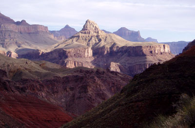
Vishnu Temple in the morning
light, seen on our hike out of the Canyon.
Everyone performed magnificently on the way out. By the
standard mountaineering rule of thumb (an hour for every two miles, plus an hour
for every 1000 feet climbed), the 8.5-mile trip, which climbs from 2600 to 7000
feet and does at least 300 feet of that twice, should take 9 hours. The three
fastest members of our party did it in 6 hours, with two following within 30
minutes, and everyone made it in less than 8 1/2 hours. Dennis led the way, but
then hiked down the road the wrong way with the wrong car key to get Elizabeth's
car. After his return, Elizabeth tried hitchhiking the right way. No luck
getting a ride, but she brought us the car.
We shuffled the cars around (there is no parking at the
New Hance trailhead, so a 0.7-mile hike was required to pick up the first car),
and arrived at Flagstaff in waves between 4 and 6 PM. The party dispersed as the
evening went on, but four of us, plus Karl's stepson Luke, finished the trip at
the Beaver Street Brewery, where we greeted the survivors of Rick Light's
Havasupai adventure who were celebrating at the next table.
We are writing this on the train ride from Flagstaff to
Lamy, planning out our next adventures as we look back fondly on this last one.
Keep your eyes on the Mountaineers trip schedule!