On a pack
trip, don't count on precise timing - moving a string of horses in and out of
the canyon is a complex business, and not something that can be scheduled to
the minute. Life is easiest if connections are not precisely timed; in
fact, our preference is to spend the nights before and after the trip in the
same town as the packer, so he can pick up and drop off our gear at our
lodging, eliminating the need for a trailhead rendezvous.
The
highlight of our first night's meal was ice cream, packed with dry ice and
insulated in a makeshift cooler of closed-cell foam, still hard 48 hours after
leaving home. Though four pints seemed a lot for our party of eleven, not much
was wasted on the hungry Mountaineers.
Special
foods that that the backpacker will never see, but the horses make possible,
included Marilyn's chocolate chip cookies and Pam's fudge bars, ice cream,
camembert and brie cheeses for appetizer, apples, yogurt, and canned
baked beans for lunch, and Shiraz, Merlot, and Chardonnay wines. A few pounds
make a big difference in comfort around camp, giving us folding chairs, pack
tables, a rain shelter, and two-burner camp stoves.
How
should you pack? Medium-size bags, like small duffles or rafter's wet sacks,
conform nicely to a pannier. Large duffles fit between the panniers for a top
load. Not advised are objects with sharp corners, like external frame packs
and cardboard boxes, that might poke the horses.
We set
out on a hike each day, looking for adventure and new routes through the
canyons. Not every route is possible, even ones that look easy on a 7 1/2
minute quad map. Technology helped our route finding. We shared 3 family
radios between our most energetic hikers, and kept in contact as they
reconnoitered the nooks and crannies that made up our path. The terrain was so
complex that we often could not see a path until we were on it.
Harris
Wash, just across the Escalante River from Silver Falls Creek,
was our first day's destination. Unlike Silver Falls, which disappeared
underground more often than it trickled across the gravel, Harris had a steady
if modest flow. This was not a hike for dry feet. Huge red walls alternated
with deep alcoves, where dwarf gardens hung to the wall, nourished by almost
invisible seeps. The footing along the creek shifted from hard gravel, to
solid sand, to quicksand into which we could settle hip-deep. But it was all
in fun - a helping hand was always there to pull you out, and the mucky
quicksand rinsed right away.
Rather
than return down the wash, we wanted to make our hike a loop. A ramp up the
canyon wall, incised with steps, gave us an easy path to the domes and
slickrock of the bench country beyond. In the little hollows of the benches we
found mosaic floors of polished stone, almost polished in their look, formed
by years of blowing sand. The trick was not in getting up to the bench, but
finding a way back down that would complete our loop. The topographic map
showed some interesting possibilities, but the surprises that hide between
forty-foot contours can certainly stop you.
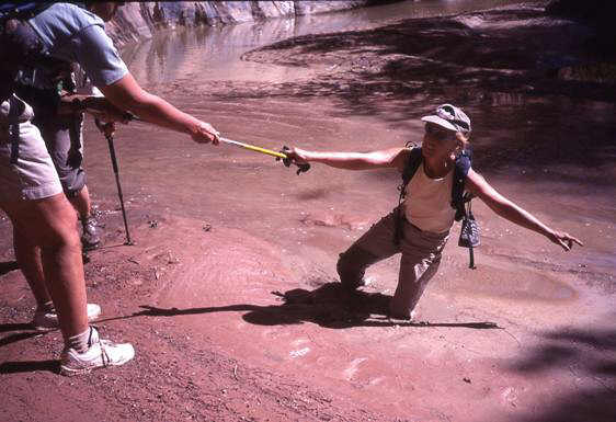
Lost in the quicksand? Not with a helping hand.
The
Escalante River ran about 500 feet below the benches. At many points,
most of the 500 feet was a sheer sandstone wall. No way down there.
Fortunately for us, the promising contours did not deceive us. An enormous
sand pile reached from the canyon floor, just high enough to touch the rim.
The descent was a series of leaps that took us to canyon bottom in about two
minutes. About an hour's hiking down the river brought us back to camp and
dinner. Our red chili was not assembled from dry ingredients, but carried
fresh from home and kept cool in the stream.
October
is, in my book, the finest time to tour the canyons. The days are no longer
hot, but comfortably in the 80 region. Nights are cool but not cold. It is
the last time of year when the days are really long enough to be out.
With Utah at the western edge of its
time zone, sunrise comes late in the last weeks of daylight time. The Milky
Way and starry sky had not faded at 6:15 AM, and there was just enough light
to move around easily at 7:00. But daylight time still gave us the
evenings - a 6 PM return to camp was safely before dark.
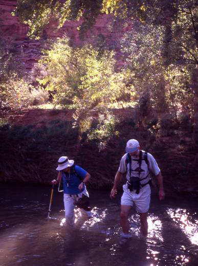
Crossing the Escalante.
Our
second day's outing was planned to go up and out via a long finger that
descended from the upper bench to an inside bend of the river. But once the
finger came into view, peeking through the cottonwoods as we hiked downriver,
our plans needed changing. Two steps, each 20-30 feet high, blocked the route
up the finger. However, our plan B worked fine - the next alcove upriver held
a sandbank reaching just to the top of the cliffs. This path was obvious from
a distance and, on closer inspection, was one of the horse paths from the
canyon to the western benches.
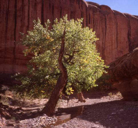
A Silver Falls cottonwood
against the red rock cliff.
From the
western bench we could see it all - the Straight Cliffs that define the
western boundary of the Escalante country, the rise to the Waterpocket Fold
that defines the eastern boundary, the distant granitic mounds of the Henry
Mountains and Navajo Mountain. And everywhere closer was slickrock - the bare
cliffs, domes, and flats that make the Escalante country.
