Crestone Needle, Ellingwood Ledges Direct
By: Gary Clark | Climbers: Gary Clark, Mark Schraad |Trip Dates: August 11, 2002
Photo: Gary Clark
® The author(s) and naclassics.com | ![]() Back to climb page
Back to climb page ![]() NAC Home page
NAC Home page
|
|
Crestone Needle, Ellingwood Ledges Direct By: Gary Clark | Climbers: Gary Clark, Mark Schraad |Trip Dates: August 11, 2002 |
|
Photo: Gary Clark |
® The author(s) and naclassics.com | |
|
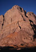
Up Ellingwood's Nose in a Day Regarding the title, so many people call this route by the incorrect name "Ellingwood Arête," that I feel somewhat justified in coining my own name. I've always wanted to be able to say I've done the Nose in a day. Mark had not yet done this mountain by any route, and we had a bit of a tradition going of partnering with him on the great classics. Since I had last done this route in a little over 3 hours and the approach is only a few miles, I convinced him that we could do a round trip from the car comfortably in a day. We drove the way-too-familiar long road on a Thursday evening, hoping to find the route uncrowded on Friday. This is an understandably popular route, and I was growing tired of sharing routes after a miserable experience on Hallett Peak a month earlier. I should have reread my trip report from 1998 before planning on driving the 4 x 4 section again. After bending an axle and destroying a tire on that trip, I remarked "I'll never drive this again in anything short of a Humvee!" This time I had a long-wheel-base full sized Chevy pickup with low-range 4WD, a marked improvement over the AWD van I mutilated in 1999, but two things conspired to prevent our arrival at the end of the road. First, it was night. Driving technical roads is bad enough in the daylight, but when the shadows from the headlights make each depression look like a bottomless yawning pit, it is downright terrifying. Second, the road seemed much worse than I've ever seen it. Erosion has turned previously reasonable sections into hideous fields of tilted bedrock, pits, and boulders. We brutalized my pickup for an hour and a half before I said "I just can't do this anymore." We had covered less than 5 miles. I got the pickup turned around and off to the side, but the latter was unnecessary - it was by now 11:00pm, and nobody else was stupid enough to attempt it that late. Mark checked his altimeter against the map, and indicated we were still a couple miles short of the parking lot. We decided to get up at 4:00am to make up for the extra hike we'd have in the morning. That night I got very little sleep. Mark had thrown a bag out in the woods, but I elected to stay in the back of the truck, which was tilted just enough to make it difficult to stay on my pad. In addition, a critter kept chewing on something under the truck. I'd crawl out, shine a light under, and it would stop. Just as I would be going back to sleep, it would start again. Just what I needed after a hard day at work and 6.5 hours of driving. 4:00am: We are up and quickly away without breakfast. I can never eat at that time of morning, so I planned on having a sumptuous breakfast of a Cliff Bar whenever and wherever I finally could chew it without gagging. As we hiked up the road, it was obvious that my decision to give up on driving was the right one - it just got worse. Let me record here, in case I remember to read this trip report before the next time, that I'll never drive this road again in anything short of a military tank. We arrived at the end of the road to find a few groggy people moving around with headlamps. There were about 5 vehicles there, so not everyone agreed with my assessment that the road was essentially impassable, or they don't care as much about their vehicles. We shuffled past them muttering greetings while I noted that there weren't any headlamps on the trail extending well above. There was at least a chance we'd have the route to ourselves, although there would doubtless be many more camped at the South Colony Lakes. There are two ways to approach the lakes - a steep direct trail on the north side of the valley, or a traversing one on the south. I've done both, and definitely prefer the south option. The trail is wide and well maintained, so it makes for pleasant hiking as it traverses a long sidehill at just the right angle to arrive at the outlet of the lower lake. From here, we crossed the creek to the north, and continued up a good trail to the upper lake. The sun was just arriving on the summit of Crestone Needle, and we enjoyed watching the peak gradually become ablaze with red alpenglow. Besides climbing the peak without a camp, I had another goal this year, which was to do the direct start. This begins at the top of the talus slope at the base of the ridge, and forms a much more elegant and interesting line than the long traverse from the left that I'd done before. There were three reasonable-looking cracks near the top of the talus, but Mark remembered that Roache's guide indicated that the highest and largest dihedral was the correct one. This was no more than 30 feet left of the absolute top of the talus cone. We agreed it wasn't going to warrant a rope, so I headed quickly up a rather blank section of face to arrive at the major dihedral. This lowest 30 feet was the crux of the lower face, at about 5.4. A rope would have done the leader no good at first, as there were no cracks until the dihedral. The dihedral itself was straightforward with a good crack and holds everywhere. I had a pair of rock shoes in my pack, but for now my approach shoes seemed quite adequate. A small roof appeared which I bypassed to the right, then back left on a small ramp to the dihedral. A few tens of meters later, the corner turned steep. I went up to find one move I wasn't willing to solo. Backing down, I opted for a short chimney on the left, which led out of the dihedral and onto some grassy ledges; the kind that give the route its name. However, we weren't quite finished with the lower difficulties yet - a steep wall loomed above, which I avoided by heading up a good crack, then around a corner to the right. There was fixed pin at the corner. This section offered about 80ft of good 5.4 climbing. Above this, we joined the major ledges of the regular route. One could climb the ledge section 50 times without going exactly the same way twice. The climbing consists of linking the ledges via short "path of least resistance" passages. The goal always was to head toward the Red Tower, an obvious feature about halfway up the true ridgeline. Just before arriving at the tower, there is a section of unavoidable 5th-class terrain as the rock steepens. The gathering exposure demanded attention. Above the Red Tower is one of the best sections of the route. Many people rope up here, but the angle is quite low, and there are only a few exposed moves as you stay very close to the actual crest. This section passes quickly in continuous vertical motion, limited only by the need to suck oxygen as one passes through 13,500ft. An occasional move of 5th class kept my attention, and a short crack of 5.4 up high looked like it might want a rope, but with the familiarity of past experience, I just kept going. We were both really enjoying this. The regular route can be thought of as having three major sections: First, wandering widely on ledges to the Red Tower. Secondly, more monolithic rock right on the crest, and finally, the headwall, a dramatically steeper section of quite monolithic rock. Many of the misadventures recorded on this climb are due to the fact that the hardest climbing is at the top. A slow party can easily get caught in afternoon storms, which can be full of snow, sleet, and lightning at these elevations, and have serious trouble with the top pitches. We arrived at the base of the headwall section around 8:00am, after having departed the talus cone around 6:50. I knew our progress would slow dramatically if we belayed the next 3 pitches, but I wanted Mark to lead since he hadn't done the route before, so we set an anchor. I told him that, if he felt comfortable, to just keep on climbing to the base of the final, crux crack. When he arrived at the bolt at 40m., I clipped into a bight, coiled the rest of the rope over a shoulder, and started up behind him for a short stint of simul-climbing. Now there was only the final crack, which I was pretty sure warranted a fixed belay. I anchored and Mark dispatched it quickly. When I arrived at the crux, I noted that there was only one move for which I was grateful to have the rope. We had carried 15 pounds of rope and hardware for just this move. We arrived on the summit at 9:10am, 2hr and 20min after leaving the talus slope at the bottom of the ridge. We had not been in any particular hurry, but there is always satisfaction in doing a route in decent time and style. I was still in my approach shoes, but certainly would have taken the time to change to rock shoes had I led the final pitch. The descent is getting easier to follow with each passing year as thousands of boots make their marks. Inevitably we kicked a few loose rocks on down, and were glad that so far we had not seen another person on the mountain. The descent is via the regular ascent route, and falling rock could be extremely dangerous for a party on their way up. We only started to run into hikers on the normal route as we approached Lower South Colony Lake around 11:00am. Why anyone would start a peak this size in midmorning is beyond me. I doubt some of them made it before the thunderstorms began. Back at the pickup, the dreaded descent of the road waited. Going down is unquestionably easier than climbing a road like this, since gravity is helping, but it is still excruciatingly slow. Several times we passed hikers, and were hard put to stay much ahead of them. I was thinking I needed a bumper sticker that reads "I'd rather be walking." Finally we reached the luxury of pavement. Seven hours later we were home. Postscript: The next time I climb this route, I will drive only to the parking lot at the beginning of the 4WD road. It is about a three-hour hike to the end of the road, where there is plenty of camping. With a reasonably early start the next morning, one can be back to the car that evening. Human impact is so serious at the few camping spots at the lakes that it does not seem justified to put a camp anywhere in the upper basin. The road should be closed and the entire area declared wilderness. Suggested rack: There are quite a few fixed pins on the route, so your gear can be minimal, even if belaying all the 5th class pitches. We placed only a few medium pieces -mostly cams from about ½" to 1", and a few medium wires. This late on this especially dry year there was no snow to be found anywhere, but an axe and crampons might well be needed in spring or early summer - make a judgment based on general snow cover remaining. |